

AZFP6-ice Deployed Near Nain, Labrador to Examine Ice Characteristics and Biological Activity in a Dynamic Environment
A prototype of the AZFP6-ice was deployed in the coastal waters approximately 40 km east of the town of Nain, Labrador, an area used for Indigenous traditional hunting and fishing. This deployment was carried out by ASL in collaboration with the Inuit Nunatsiavut Government in October 2021 and will be recovered in the fall of 2022. The AZFP6-ice combines the technology of the Ice Profiling Sonar (IPS) with its ability to detect ice draft along with the calibrated Acoustic Zooplankton Fish Profiler (AZFP) echosounder to examine zooplankton, fish, bubbles and suspended sediments within the water column. The upgraded IPS component used in this unit includes a logarithmic detector to prevent signal saturation of strong targets while at the same time still providing information on weak targets. This revised version of the IPS is referred to as the Log IPS. The AZFP6-ice at this site will be used to better understand the impact of climate change on the ice and biology of the region. A notable ocean-ice feature in this region are year-round ice-free areas, locally referred to as rattles or polynya. These year-round ice-free areas are considered biologically rich. Placement of the mooring this year was “downstream” from a known rattle location in order to provide insights into the biological activity and ice dynamics associated with this ice-free feature. The results from a Log IPS deployed approximately 500 m away, as well as two previous years of IPS data collected in this location, will provide a useful comparison with the new AZFP6-ice data along with the now added benefits of the bioacoustics echosounders.
Log IPS data from a previous deployment from 2020/2021 revealed a dynamic environment with some days exhibiting a full range of open water, waves, flat level ice and moderately sized keels measuring up to 13 m drafts. This instrument had a sampling rate of 2 Hz and was deployed through the ice at a depth of about 100 m on February 15, 2020 and recovered 263 days later on October 27, 2020. With the improved capabilities of the logarithmic detector, the instrument detected enhanced backscatter at the air–water interface suggesting the potential of the instrument to resolve the presence of frazil ice and differentiate between consolidated and unconsolidated ice.
With this year’s deployment of the AZFP6-ice, further insight will shed light on this dynamic region and provide useful information to help manage the risks associated for those that traverse this area.
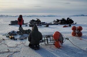
Through-the-ice deployment of the Log IPS on February 15, 2020. The Log IPS mooring cage is shown on the right along with an ADCP cage in the foreground to measure currents.
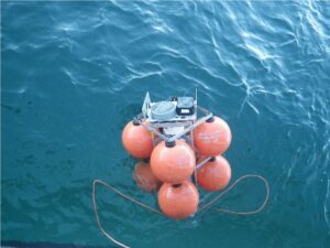
An AZFP6-ice being deployed near Nain, Labrador in October 2021. Both the AZFP and the Log IPS transducers are visible at the top of this mooring.
For additional information, please visit www.aslenv.com
or contact Jan Buermans [email protected]

NIWA-Nippon Foundation Tonga Eruption Seabed Mapping Project a "rare opportunity" to study effects of Tonga eruption
NIWA and The Nippon Foundation are undertaking a mission to discover the undersea impacts of the recent Tongan volcanic eruption.
In a rare opportunity to improve understanding of the nature and impact of a major volcanic eruption, NIWA scientists are sailing to Tonga to survey the ocean around the Hunga-Tonga Hunga-Ha'apai (HT–HH) volcano and surrounding regions. They will be surveying thousands of square kilometres of the seafloor and collecting video images of the eruption’s impact from NIWA’s research vessel, RV Tangaroa, and using SEA-KIT International’s Uncrewed Surface Vessel (USV) Maxlimer to conduct further mapping.
The NIWA-Nippon Foundation Tonga Eruption Seabed Mapping Project (TESMaP) is being funded by The Nippon Foundation – the largest non-profit organisation based in Japan which, amongst other philanthropic activities, has been facilitating projects in the ocean field since 1962. The research is also supported by The Nippon Foundation-GEBCO Seabed 2030 Project which aims to map the world’s ocean floor by 2030.
Project leader and NIWA Chief Scientist Oceans Mike Williams predicts that there will be extensive changes to the underwater landscape around Tonga.
“Before the eruption, much of the volcano was above water but now none of it is and the neighbouring islands of Hunga Tonga and Hunga Ha'apai were reduced in size. We expect similarly dramatic changes to have occurred in the underwater topography.
“Submarine cable breakages show impacts up to 50 kilometres from the volcano caldera, implying changes to the seabed over an area of at least 8,000 square kilometres. This survey will investigate the impacts of the eruption in the water column and on the seabed around HT–HH.”
The eruption was unprecedented and unexpected; volcanos of this type were not previously anticipated to erupt so violently or trigger such large explosions.
Dr Williams says that with similar volcanos around the globe, particularly along the Pacific Ring of Fire, the eruption of HT–HH highlights a risk to society from our lack of knowledge about them.
The Nippon Foundation Chairman Dr Yohei Sasakawa says that this research is vital to help protect people from similar natural disasters in the future.
“By working together, we have the power to help solve some of the biggest problems facing society, including the fall-out from natural disasters.
“We hope that this work will help researchers and governments understand and mitigate the risk of future eruptions, which will be of particular benefit to countries that lie within proximity of these threatening natural wonders, like Japan and New Zealand.”
Tonga’s Deputy Secretary for Lands and Natural Resources Taaniela Kula says that the eruption of the HT–HH volcano on January 15, 2022, had catastrophic consequences.
“It covered our main island of Tongatapu in carpets of toxic ash, generated a sonic boom that travelled around the globe and caused a tsunami that resulted in deaths and damage as far away as South America.
“It also severed both submarine fibre optic cables connecting Tonga with the world, leaving our country in a prolonged “blackout”. The direct economic impact of the eruption is estimated by the World Bank to be over $US90m. As a country we’re building back slowly. We hope this research will help in the efforts to protect our nation and others like us in the future.”
The TESMaP project will take place in two parts – NIWA’s research vessel Tangaroa, will set sail next week [9 April] to do the first part of the surveying. Following that, SEA-KIT International’s 12-metre-long USV Maxlimer, in coordination with Seabed 2030, will remain at sea for an additional month of mapping and environmental data collection.
Scientists will gather acoustic data using echosounders to determine the shape and structure of the underwater landscape, including the thickness of ash deposits and the formation of any new bedforms. This data will then be compared with previous maps to identify areas for sampling, so that further changes to the area, such as impacts to marine life and the seafloor’s chemical composition, can be assessed.
Kevin Mackay is head of the South and West Pacific Regional Center of Seabed 2030 and the voyage leader. He says that the collective knowledge, experience and resources of the organisations involved will help build a detailed and invaluable picture of the eruption’s aftermath.
“By working alongside and pooling resources with such a multinational team, we’ll be able to gather an incredible amount of information of what happens during eruptions like these, what the impacts are, and how we can be better prepared next time a similar event occurs.
“There is much we still don’t know about the natural world, especially what occurs under our oceans, so we’re delighted to take this opportunity to build our knowledge and help Tonga’s people and environment.”
Ben Simpson, CEO, SEA-KIT International, says it is an exciting opportunity to demonstrate data collection using less than 2% of the fuel of a typical survey vessel.
“USV Maxlimer will be controlled from the other side of the world, at our base in the UK, as she safely gathers a range of data types from inside the caldera for a full month to develop and support understanding of the eruption’s undersea impact.”

Business Development & Marketing - Ocean Science Consulting Limited (OSC)
Position: Business Development & Marketing
Employment: Full-time/permanent
Salary: Competitive, depending on qualifications and experience
Location: Dunbar, East Lothian, UK
Deadline: Rolling - open until filled
Ocean Science Consulting Limited (OSC) is a technology-focused marine science company involved principally in providing marine mammal and underwater-sound monitoring, acoustical and statistical modelling, ROV surveys, and image-data analyses, and is currently expanding its services portfolio.
OSC is seeking a highly motivated professional, with strong commercial awareness and previous experience of offshore industries (e.g. windfarms, tidal energy, oil & gas, decommissioning, etc.) to join its growing team. The successful candidate will identify and generate business opportunities in new sectors and/or markets, build and maintain profitable partnerships with stakeholders, develop and execute business strategies, and work in collaboration with technical and scientific staff to contribute to preparation and submission of business proposals and tenders.
Additional details: https://www.osc.co.uk/careers/
Responsibilities:
- Maintain and expand client base to develop strong professional relationships;
- Identify opportunities and engage via email, telephone, and in-person;
- Liaise with Directors & senior managers to plan and execute new business strategies;
- Follow up with clients to ensure opportunities progress and clients are satisfied;
- Manage marketing tasks to effectively and efficiently respond to opportunities; and,
- Coordinate with other staff to prepare proposals, marketing and presentation materials.
The successful candidate will have the following:
Required:
- A degree (minimum 2:1) in a relevant business, economics or environmental discipline;
- Minimum of three years relevant commercial experience;
- Strong business acumen, client-oriented, and focused on results;
- Excellent written and verbal communication skills in English;
- Ability to develop strong relationships, and work effectively across teams; and,
- Demonstrated sales drive, determination, and dedication.
Please send your CV and cover letter to [email protected]. Please also supply contact details for three clients who we can contact for references. Applications will be reviewed on a rolling basis.

Hydromea launches a new underwater wireless optical modem LUMA X-UV
Hydromea is launching its new patent-pending subsea wireless communication modem LUMA X-UV. The LUMA X-UV can beam data at up to 10 Mbit/s in the presence of other light sources in the environment, enabling real-time streaming of HD-quality video and 4K images wirelessly through water. It will be a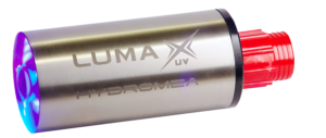 critical tool for wireless control of underwater vehicles that have their lights on during missions or for deployments in shallow waters.
Felix Schill, co-founder and CTO of Hydromea, says:
“LUMA X-UV is another big step forward in providing unlimited access to subsea data. It is a tool with a lot of versatility built in. It can be used as a modem and as an access point in subsea infrastructure. Moving the data stream into the UV wavelength with LUMA X-UV, this modem will work in the presence of other light sources, such as ROV lights. It will also be the best communication tool in shallow waters where there is still a significant amount of ambient light.”
Igor Martin, co-founder and CEO of Hydromea, adds:
“Our LUMA modems are getting increasingly used across various setups and environments underwater. LUMA uses light to exchange data wirelessly, which means other light sources can create interference and reduce the effectiveness of such communication. Our new LUMA X-UV provides our customers with a perfect solution to this problem.”
Hydromea focuses its development on affordable, autonomous and miniaturized devices that can be used at any ocean depth for unprecedented data access. LUMA X-UV comes in a titanium housing with a serial and ethernet connection and will be pressure-rated to 6’000 meters depth.
Founded in 2014, Hydromea is a Swiss-based underwater robotics company helping its customers to have unparalleled underwater data connectivity and efficient remote inspection access to submerged assets.
OFG, in partnership with PGS, acquires NCS, the owner and operator of P-Cable ultra-high resolution seismic acquisition technology
Ocean Floor Geophysics, Inc (OFG), in partnership with PGS, is pleased to announce that it has signed an agreement to acquire NCS SubSea, which provides ultra-high-resolution 3D seismic data to the oil & gas and new energy markets via their market-leading P-Cable system.
With the addition of P-Cable technology, OFG now provides the broadest range of marine geophysical data technology and services available in the offshore market today, offering the widest range of sensor solutions from surface, AUV and ROV platforms, combined with unique multiphysics processing, integration and interpretation know-how.
OFG was assisted in this transaction by PGS, OFG’s largest shareholder and strengthens the strategic alignment collaboration between OFG and PGS. The PGS New Energy group, which services markets including carbon capture and storage (CCS), renewables (wind farms) and seabed minerals, works closely with OFG as a preferred supplier of ultra-high-resolution seismic, CSEM, magnetic and acoustic surveying products and services.
“OFG is delighted to add P-Cable to our already extensive range of geophysical products and services. Interest in ultra-high-density 3D seismic is growing apace, driven by rapid growth in the market for offshore wind. We look forward to bringing OFG’s considerable expertise in operation and engineering to the P-Cable system, to further improve robustness and reliability, and extend the operating envelope,” says Matthew Kowalczyk, CEO of OFG.
“PGS remains a dedicated and reliable pioneer serving the energy industry with our integrated geophysical data acquisition and processing capabilities. Our strategic collaboration with OFG and their acquisition of NCS SubSea further expands our offering within the New Energy markets. By bringing the ultra-high-resolution P-Cable 3D seismic technology into OFG, we can apply PGS’ inhouse data processing capabilities, expanding our offering for site characterization and shallow geohazard applications,”
says Berit Osnes, EVP New Energy of PGS.
New four-strong Seaglider fleet ready for action
Cyprus Subsea Consulting Services Limited delivers significant ocean monitoring capabilities with new glider rental and services portfolio
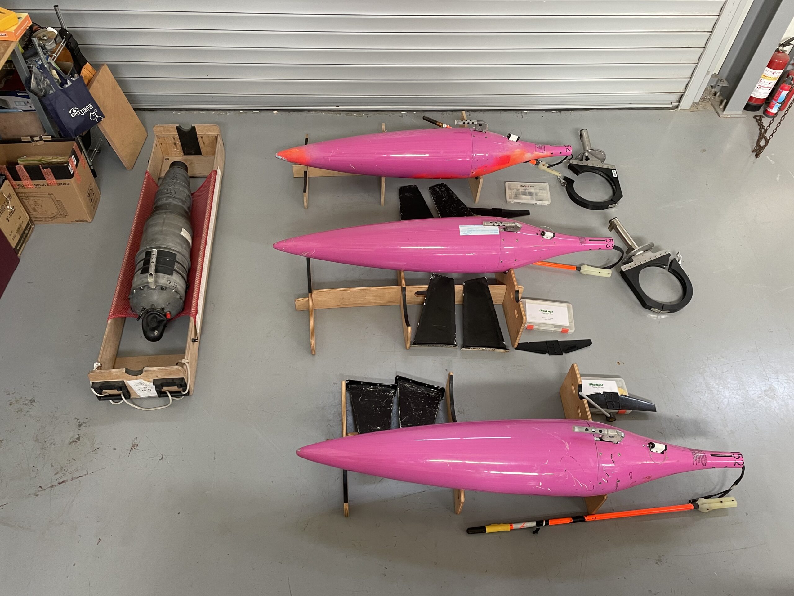
Cyprus Subsea Consulting Services Limited has established a fleet of four Seaglider AUVs to unlock new long-duration subsea survey and monitoring capabilities for research and commercial organisations. Featuring four M1 Seagliders acquired in February 2022, the new privately-owned fleet is one of the largest of its kind in Europe and is ready for operation now.
With more than a decade of supporting clients on scientific, regulatory, and commercial Seaglider projects globally, Cyprus Subsea’s 1000-meter rated M1 Seagliders are a major boost in its capacity to provide real-time environmental monitoring services in the open seas for diverse applications.
The fleet enables customers to leverage glider capabilities for one-off or short-term projects without the need for investing in glider infrastructure or specialized staff. Larger organisations may also benefit from leveraging the new fleet as a lower cost alternative to maintaining internal glider capabilities all year round.
“For gliders to fulfil their full potential as a cost-effective, low carbon marine monitoring and research tool, the barriers to their usage must be reduced or removed. The learning curve and initial investment are too high for most, and we believe we can help by providing our expertise and assets as a turnkey solution anywhere in the world,”
said Daniel Hayes, Managing Director, CSCS Ltd.
Equipped with a variety of sensors, Cyprus Subsea’s state-of-the-art gliders acquire ocean profile data such as temperature, salinity, and dissolved oxygen, as well as biogeochemical, biological, and acoustic data. Pilots on shore manage the on-board autopilot system and sensor payload configuration via satellite.
An underwater glider is a highly efficient autonomous underwater vehicle (AUV) which utilizes slight changes in buoyancy, pitch and roll to achieve forward, profiling, motion over long distances. They are a reusable, cost-effective method for collecting repeat subsurface ocean observations. Mission endurance is measured in months, with the gliders surfacing to transmit data to shore.
Cyprus Subsea is taking a flexible approach to provision of its new Seagliders, with related services including mission planning, launch/recovery, piloting, maintenance, training, in addition to data management, analysis and reporting all available according to project requirements.
The company’s DeepEcho Module for identifying and quantifying components of the marine ecosystem on a range of scales, the gListen Board and the UVP6-LP Underwater Vision Profiler will also be available as part of Seaglider rental packages.
3D at Depth Continues Expansion of Marine Robotics Solutions
Subsea LiDAR laser technology leader 3D at Depth announces the newly engineered Cuvier DEEP
3D at Depth, the global leader in commercial subsea LiDAR laser technology, continues expansion with a marine robotics solution. It is proud to announce the launch of the newly engineered and renamed Cuvier DEEP. This automated underwater solution combines class-leading sensors and high-end system performance with operational efficiency and unparalleled data quality in one solution — leveraging 3D at Depth's new SL4 technology released in late 2021.
Neil Manning, Chief Operating Officer, stated, "Our fully integrated marine robotics solution allows us to not only expand our service offering but also continue to offer high data quality from the SL4 Subsea LiDAR and other geophysical, electromagnetic measurement and inspection sensors used across the marine energy and inland energy generation facilities. We have developed the new service delivery and application by evolving the trusted and highly stable hovering unmanned 3,000m deep-water dual-hull SAAB Sabertooth Underwater System. The system design has then been modified to enable greater endurance and more diverse sensor payload integration, meaning both greater in water operational time and higher data capture accuracy for our clients. Our innovation has been heavily influenced from years of marine design and operational experience to unlock an operationally unique platform with incredible agility. The result is a highly adaptive work platform that greatly reduces the on-deck turnaround time due to a modular power solution. The increased endurance of up to 30 hours (depending on the mission requirements) exceeds all market comparable solutions currently operating in the marine AUV/UUV market. Cuvier DEEP is supported by impressive communication options including fully untethered supervised autonomy. Small fiber optic or powered cabled solutions means the system is configurable to meet all asset integrity work scopes covering deepwater offshore energy.
"The name Cuvier DEEP is inspired jointly by George Cuvier (1769-1832) and the Cuvier beaked whale. French-born academic Cuvier had many attributes and studies during his career, with one particular focus on him establishing proof that many species like dinosaurs had become extinct in ages past. Cuvier, therefore, proposed that, after each series of major ecological events, new species had been created.
"For the blue economy, global climate change and energy transition can be related as a major ecological event. Cuvier's work on extinctions was incorporated into Charles Darwin's theory of natural selection and survival of the fittest. Cuvier also expressed multiple evolutionary changes would happen at the same time following a catastrophic event, stimulating forced evolution in species. This is in keeping with the multiple modifications that we're applying both to the SAAB Sabertooth hybrid AUV/ROV and to our service applications."
Manning also stated, "If that wasn't enough, the Curvier beaked whale's performance in many aspects is similar to the specification that we've engineered for the Cuvier DEEP. With a similar length and a diving depth of around 2,992m, the Beaked Whale holds the record for the longest and deepest diving mammal. With this impressive backdrop, the Cuvier DEEP name seems a perfect fit."
Over the following months, more technical information will follow that is focused on the System launch and recovery solution, a subsea habitat, and widespread sensor wing innovations and manipulation. All of these solutions are set to shake up the blue economy "norm." Cuvier DEEP will deliver a new level of efficiency alongside the data quality standards expected by the clients of 3D at Depth. 3D at Depth continues business growth through innovation and a focus on lowering carbon and vessel time savings, from crewed and un-crewed surface vessels.
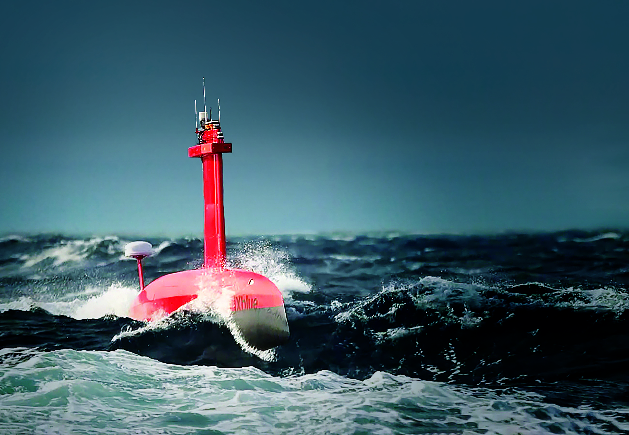
iXblue ramps up DriX USV production following strong commercial successes
As the maritime industry makes its transition towards more efficient and environmental-friendly autonomous operations, iXblue, a key player in maritime autonomy, has been ramping up its production of DriX Uncrewed Surface Vehicles (USV) to meet the industry growing need for efficient and sea-proven autonomous platforms.
With over 20 DriX in operation worldwide, iXblue USV, that was launched back in 2017, has been met with strong interest from the industry and is benefiting from a steadily growing commercial success. The USV has already been acquired, deployed or trialed by several industrial companies and scientific institutes for seabed mapping missions and other subsea positioning operations. Those includes governmental institutions such as the US National Oceanic and Atmospheric Administration (NOAA), the British Antarctic Survey (BAS), the Polish Navy, the French Hydrographic Institute (SHOM), or the French Research Institute for Ocean Science (Ifremer), as well as survey contractors and operators in the energy market such as TotalEnergies, Ocean Infinity, Sulmara and other rental companies such as Unique, or WAMS.
“We would like to thank all our customers for choosing our DriX USV as they transition towards autonomous operations.” states Olivier Cervantes, VP Maritime & Autonomy at iXblue. “DriX versatility, both in terms of mission types, and working environments, as well as its reliability and overall performance, has indeed translated into fast commercial success, This strong increase in order intake has led us to review our whole industrialization process for series production with the aim of strongly reducing our lead time, resulting in quicker deliveries and availability of our DriX USV for our customers.”
Designed to support hydrographic and geophysical surveys, water column analysis and subsea positioning operations from shallow to medium water depths, iXblue DriX USV can conduct both remote-controlled and supervised autonomous operations (within visual range or from Onshore Remote Control Centers). DriX, that comes with an efficient and certified Launch and Recovery System, offers outstanding seakeeping and speed capabilities, drastically reducing costs and increasing operational efficiency. Able to host a wide range of payloads for multi-capabilities missions, DriX is a versatile autonomous platform able to operate in both shallow and deep waters (from 2m to 2500m). Certified by leading class society (BV, Lloyd’s), the USV is equipped with advanced perception means, including a radar, a lidar and cameras, as well as artificial intelligence, which enable it to adapt to its environment, avoid obstacles and carry out missions autonomously.
As a leading developer of industry-changing autonomous and uncrewed technologies, iXblue further offers a complete ecosystem around the concept of maritime autonomy. Enabling efficient deployments and successful missions, iXblue solutions ensure the smooth transition of the industry towards remotely supervised maritime operations.
Ashtead Technology signs rental agreement with OceanTools
International subsea rental equipment and solutions specialist Ashtead Technology has signed an exclusive rental agreement with Aberdeen based OceanTools, a subsea engineering company specialising in the design and manufacture of underwater technologies. Under the terms of the agreement, Ashtead Technology will be the exclusive rental partner for OceanTools’ DyeTectors™ systems, including the latest D10 DyeTector ®, an advanced subsea leak, dye and cement detector developed with three sets of optical components to detect the three primary dyes used for underwater detection - rhodamine, ultraviolet and fluorescein – using a single compact device.
Brian Hector, OceanTools, Technical Sales Manager, said:
“We are delighted that Ashtead Technology will be promoting our range of OceanTools DyeTector™ systems including the new D10 DyeTector ®. We look forward to working together to supply our innovative products to their extensive global network and dedicated customer base. The new rental agreement is an important strategic opportunity for OceanTools and will significantly support the steep growth of
our business”.
Brett Lestrange, Ashtead Technology’s Regional Director for Europe, added:
“The exclusive agreement with OceanTools further enhances our existing inventory of leak detection equipment for underwater survey and inspection operations. It also demonstrates our ongoing
commitment to the global offshore energy market by offering the latest and most technologically advanced technologies to support our customers’ projects worldwide. We look forward to seeing these systems performing in the field and delivering excellent results for our customers.”
OceanTools’ DyeTector™ systems are used to detect leaks from underwater infrastructure suchas manifolds, wellheads or pipelines if a suitable dye has been added to the infrastructure
fluids. They can also be used during casing cementing operations to detect cement returns if a tracer dye is added to either the seawater spacer or to the cement itself. The powerful ROV mounted D10 DyeTector ® uses the same technology capable of detecting single photons of light as the single channel D7 DyeTector ®, which enables it to detect down to single digit parts per billion of dye dissolved in water. This makes it ideal for detecting the very smallest of leaks or dye dosed cement.
The Nippon Foundation-GEBCO Seabed 2030 Project signs collaboration agreement with the UK Hydrographic Office

Peter Sparkes, Chief Executive at UKHO (left) and Jamie McMichael-Phillips, Seabed 2030 Project Director
The Nippon Foundation-GEBCO Seabed 2030 Project has today signed a memorandum of understanding (MOU) with the UK Hydrographic Office (UKHO), which will see the parties work together to advance the industry’s understanding of ocean bathymetry, and in support of the Decade of Ocean Science for Sustainable Development.
Seabed 2030 – a flagship programme of the Ocean Decade – is a collaborative project between The Nippon Foundation and the General Bathymetric Chart of the Oceans (GEBCO) with the goal of the complete mapping of the world's oceans by 2030, as well as compiling all bathymetric data into the freely available GEBCO Ocean Map. GEBCO is a joint programme of the International Hydrographic Organization (IHO) and the Intergovernmental Oceanographic Commission (IOC), and is the only organisation with a mandate to map the entire ocean floor.
As part of its official partnership with Seabed 2030, the UKHO will provide bathymetric gridded map products to be used by the project within the GEBCO gridded bathymetric data set. UKHO will also share and promote methods and best practices in technological innovation, infrastructure, and solutions for ocean mapping and bathymetric data management.
The MOU signed today follows the technical cooperation agreement that the UKHO, Seabed 2030 and Teledyne CARIS entered into in June 2021 to advance efforts in producing the definitive map of the seafloor by the year 2030.
Commenting on the announcement, Peter Sparkes, Chief Executive at the UK Hydrographic Office, said: “Today marks an important date in our partnership with Seabed 2030 as we initiate the release of identified data contributions to the project. As a world-leading centre for hydrography, we share the Seabed 2030 vision and believe that the full mapping of the world’s oceans is a key milestone in supporting safe, secure and thriving oceans.
“Knowing the depth of the seabed is of vital importance for navigation and coastal management. It is a fundamental parameter for understanding ocean circulation, tides, wave action, sediment transport, environmental change, underwater geo-hazards, cable and pipeline routing, and much more. High quality marine geospatial data will play an instrumental role in Seabed 2030, and we are delighted to actively support and contribute to the project’s mission.
“By working alongside international governments. commercial partners, institutions and initiatives such as Seabed 2030, we will continue to engage with the wider geospatial and technology community to meet the changing needs of all those who depend on the marine environment and ensure the best use of our oceans in safer, more secure and more sustainable ways.”
Seabed 2030 Project Director Jamie McMichael-Phillips added:
“We are delighted to further develop our partnership with the UKHO in support of producing the complete map of the ocean floor.
“With eight years left until the end of the decade and 80 per cent of the sea floor still to be mapped, UKHO’s data contribution and expertise on ocean mapping solutions will no doubt play a significant role in supporting Seabed 2030 realise its essential goal, for the benefit of humanity.”