

Hexagon | VERIPOS expands SPAN GNSS+INS portfolio for dynamic positioning
Ensure safe operations through reliable, robust and continuous positioning with GNSS+INS integration
Hexagon | VERIPOS is proud to expand its proven inertial solution SPAN GNSS+INS technology from NovAtel, also part of Hexagon, to dynamic positioning (DP) applications and vessels. SPAN technology delivers a deeply coupled GNSS and inertial navigation system (INS) that provides robust, reliable and continuous centimetre-level positioning for operators to maintain safety and maximise uptime. With a GNSS+INS solution, DP vessels can bridge outages in GNSS tracking and through short periods of radio frequency interference, jamming or spoofing.
VERIPOS is a leader in offshore high precision positioning, delivering reliable and trustworthy GNSS solutions like the LD900 receiver, PPP correction services and positioning visualisation software. They demonstrate this expertise through SPAN technology’s deep coupling of GNSS and inertial measurements. Deep coupling describes how inertial measurements enhance the signal tracking for GNSS solutions, leading to improved resiliency against GNSS outages and enabling rapid reacquisition in case of interruptions. SPAN technology builds system robustness against potential signal outages, interference or disruptions while optimising operational efficiency.
“The robust positioning, heading, velocity and attitude measurements generated from a deeply coupled GNSS and inertial solution like SPAN technology is a game-changer to dynamic positioning operations,” said Dr. David Russell, marine segment portfolio manager at Hexagon’s Autonomy & Positioning division. “SPAN technology has a proven track record of bridging outages, enabling rapid reacquisition of signals and building a reliable and robust positioning system. It’s the best option for vessels to ensure an added layer of resiliency and achieve continuous centimetre-level accuracy across all conditions.”
SPAN GNSS+INS technology is compatible with commercial inertial measurement units (IMUs) and scalable with your LD900 GNSS receiver, Quantum visualisation software and APEX correction services.
Visit veripos.com/SPAN to explore how SPAN GNSS+INS technology provides robust and reliable positioning for safe, continuous and efficient operations.
Learn more about inertial sensors and the benefits of a deeply coupled system in chapter five of Introduction to GNSS and Beyond.
For further information, please contact:
Product Inquiries: Media Inquiries:
Dr. David Russell Jessica Fielding
Marine segment portfolio manager Senior manager, global marketing
Hexagon’s Autonomy & Positioning division Hexagon's Autonomy & Positioning division
T: +44 1224 965874 T: +1 403 919 3388
Click here to Email Click here to Email


Fugro USV Project Team wins Energy Industry Game Changer Award
Fugro’s Blue Essence uncrewed surface vessel (USV) has been awarded the Energy Industry Game Changer Award at the 2021 Energy Club WA Award, an initiative of the Australian Institute of Energy (AIE). The award is presented to an individual or team who have made an outstanding contribution to the energy industry resulting in significant advancement of the industry’s knowledge and capability.
The Fugro and Woodside teams were presented with the award following the successful completion of the first entirely remote inspection project on 125 km of Woodside's gas trunklines, utilising the new Blue Essence 12 m USV, Fugro Maali in 2021.
Fugro’s USV offers a unique solution for subsea inspection that requires no offshore crew and demonstrates the many benefits of remote operations such as a reduction in CO2 emissions by up to 97% when compared to a traditional vessel solution, and the ability to remove personnel from high-risk environments. The USV and e-ROV conducted successful over-the-horizon operations during the project, further demonstrating the capabilities of this technology.
Paul Mullins, Director of Remote Operations for APAC said: “Fugro’s USVs and remote operations are changing the way the industry carries out subsea inspection operations and over the coming year the team will be pushing the boundaries on additional USV capabilities.”

Intelligent cougar for Japan's offshore renewables
Japan’s growing offshore wind industry is gaining a Saab Seaeye Cougar XTi underwater robotic vehicle for cable burial inspection and other roles.
Kaiyo Engineering has acquired the 2000m rated Cougar, incorporating intelligent control architecture, for deployment from a 250ton mother ship, the Kaiyo Maru.
The ship is one of a fleet of vessels belonging to Kaiyo Engineering, the only privately owned research and observation company in Japan.
The Cougar XTi adds to Kaiyo’s portfolio of Saab Seaeye robots that include a Leopard and a Falcon.
In addition to its cable inspection role, the Cougar will also be used by Kaiyo Engineering to cover additional Leopard work.
Worldwide, Saab Seaeye robots play a dominant role in offshore renewables, as they are technologically suited for the challenges involved in building and maintaining structures and interconnections.
The Cougar XTi is a particular favourite. With its six powerful thrusters it can hold steady in cross currents and operate with precise manoeuvrability whilst fitted with a wide array of equipment.
Kaiyo’s Cougar comes with four Imenco cameras, a Tritech SeaKing sonar, Nortek DVL and station-keeping software, and a five-function heavy duty manipulator with camera.
Its intelligent iCON™ behaviour-based ecosystem endows each device with its own microprocessor for individual control and real-time feedback, in a modular future-flexible system that allows for further development and innovation.
The entire Kaiyo Cougar XTi operational configuration includes a launch and recovery system (LARS), tether management system (TMS) and 20ft control cabin and workshop.
Supporting the successful acquisition of the Cougar and other robotic systems is Saab Seaeye’s distributor in Japan, Marimex Japan K.K.
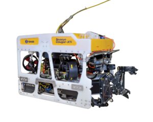
The Saab Seaeye Cougar XTi for Kayo Engineering can operate precisely in strong currents whilst fitted with cameras, sonars and tools.

Investment Opportunity in Resen Waves
Resen Waves has reached an important milestone in its efforts to develop a commercial platform to grow internationally. The focus is on small-scale commercial 300W to 3kW Smart Power Buoys which provide autonomous power in the sea and instant data communication with instruments or AUV docking stations on the seabed, no matter where they are in the oceans.
The solutions can replace traditional ship operation for survey work in the offshore industry as well as in the fast-growing offshore wind industry. It is CO2 neutral; reduces operational survey cost by up to 90% and improves human safety in the sea. Every ship taken out of operation saves 10.000 tons of CO2 per year.
We are proud to announce our technology will be used for monitoring the first large-scale CCS “Project Greensand” in the Danish sector of the North Sea which begins this year (2022).
For 2022 and 2023 we will be a profitable business - probably the first dedicated wave energy company in the world to achieve this.
Per Resen Steenstrup, Founder and CEO stated: “We would like to meet with like-minded investors to support our growth and agree how to take Resen Waves to the next level, he continued “this could be via a change in ownership or shared investment in the region of 3- 4M€ - I look forward to sharing further information on our plans and finances.”
Innovations that power your operations headline Sonardyne’s theme for Oi2022
Marine technology company Sonardyne will use next week’s Oceanology International exhibition and conference in London to present the first of its new products and services for 2022 targeted at answering operational challenges across energy, defence and science.
On Sonardyne’s stand, F300, and as part of the daily in-water programme, visitors will be able to experience innovations for crewed and uncrewed vehicle platforms, seafloor and structure surveillance, and remotely connected, over-the-horizon missions.
Making its global tradeshow debut is Initiation Transponder 6 (IT 6), an entirely new way to remotely and securely activate mine neutralisers used in unexploded ordnance (UXO) and mine countermeasures (MCM) clearance operations. It can be placed by a remotely operated vehicle (ROV) or diver and is suitable for both high order detonation and low order deflagration methods.
IT 6s are controlled using Deck Topside, Sonardyne’s new portable control unit that can be used all day, in any weather, and from any size of boat. Sonardyne is using Oi2022 to show how Deck Topside is the future of its back-deck command, control and communications offering with the first look at a valuable functionality addition.
With Deck Topside, users can now acoustically test, load, interrogate and activate their Sonardyne RT 6 acoustic release transponders, as well as IT 6s, simplifying the topside choices on offer.
On start-up, users simply decide which mode they want Deck Topside to operate in; RT 6 or IT 6, with the 7-inch touchscreen displaying a bespoke user interface configured for that particular operation.
Oceanology also sees the arrival of the latest release of Fusion 2, Sonardyne’s LBL and INS software package. The latest release includes boosting Fusion 2 to 64-bit capability. The increased program performance this provides has resulted in faster processing and the most stable version of Fusion 2 ever.
GNSS signal loss when operating in built-up inland waterways and near large offshore structures, such as wind turbines, is a problem Sonardyne’s SPRINT-Nav family will address during its two daily in-water demonstrations at the show. SPRINT-Nav combines DVL, INS, AHRS and depth sensing in one easy to integrate instrument. Sonardyne will show how, with SPRINT-Nav fitted to any inshore, uncrewed or shallow-water DP vessel, independent, high-grade navigation can be continually available.
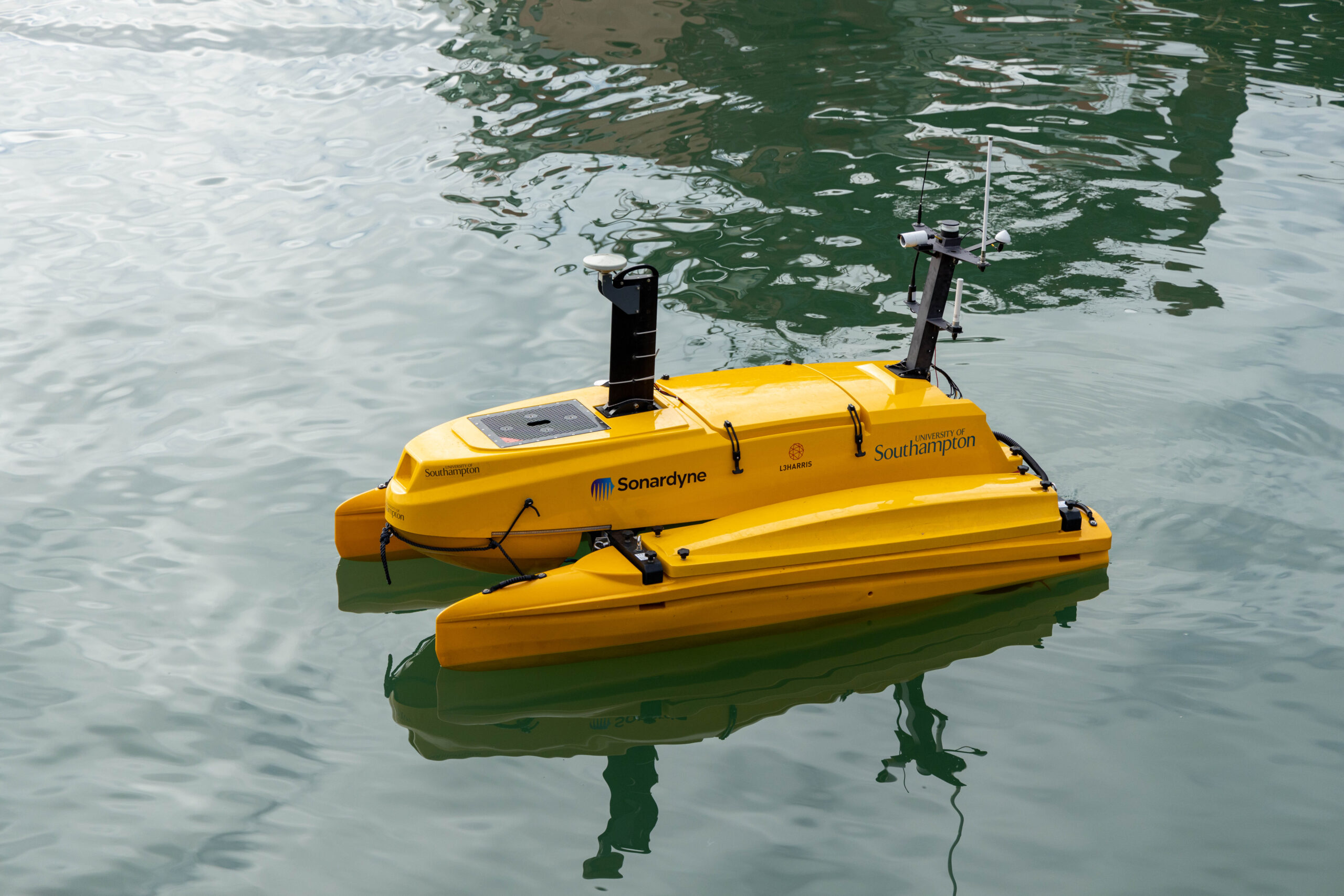
Staying with challenging operational environments, Sonardyne’s has brought a Mini-Ranger 2-enabled USV to the dockside to highlight the features that make this USBL system a great choice for high elevation underwater tracking, the ultimate test for any underwater positioning system.
Back inside, on stand F300, experts from the company’s Technology Services and Custom Projects groups will be on hand in a dedicated consultation zone, figuring out the subsea engineering challenges visitors are encouraged to present the team with.
Steve Martin, Sales Director at Sonardyne said: “Whilst the specific application challenges our clients face vary from renewables to underwater security, the need for marine technology which enables operations to be carried out responsibly, safely and efficiently is common. These needs are front and centre of our technology roadmap. Oceanology represents our first opportunity for what will be several product announcements that we have lined up over the course of this year.”
He added: “After two years of not being able to connect in person, we’re thrilled to welcome our industry back together again face-to-face to experience the latest innovation at Oi 2022."
Image Caption: At Oi2022, Sonardyne’s will use a USV to demonstrate its innovations for uncrewed, remote and navigation denied operations across the marine space.

Subsea Europe Service GmbH appointed as new GeoAcoustics Ltd partner
GeoAcoustics Ltd is pleased to report the recent signing of a partnership agreement with hydroacoustic technology specialist Subsea Europe Services GmbH, who will add the GeoPulse Sub Bottom Profiler technology to its subsea sales & rental portfolios. The agreement with the Hamburg, Germany-based marine survey sensors, services and solutions provider builds on the extensive worldwide partner network GeoAcoustics Ltd has established since becoming an independent company.
GeoAcoustics Ltd now has approved representation in 70 countries from China and Singapore to the USA and Scandinavia.
“With experience and access to the North Sea coastal zone and offshore sectors, as well as reach into European inland waterways, we expect our partnership with Subsea Europe Services to meet existing demand while opening up new areas and applications for our products,” said Richard Dowdeswell, General Manager, GeoAcoustics Ltd.
“The GeoAcoustics name is synonymous with reliability and effectiveness in the shallow water market, and we are pleased to bring the quality and functionality it represents into our portfolio for sales and rental customers,” said Sören Themann, CEO, Subsea Europe Services GmbH.
Find out more about Subsea Europe Services GmbH at https://www.subsea-europe.com and locate your nearest GeoAcoustics partner at https://geoacoustics.com/channel-partners.

Tropical seafloor secrets discovered as mission to map world's entire seabed gains momentum
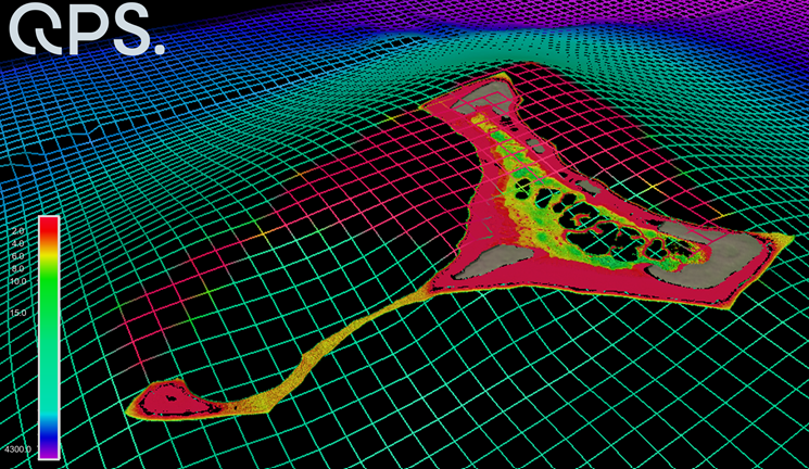
Satellite technology has been used to chart shallow areas of the Cook Islands’ seafloor in never-before-seen detail by scientists at the National Institute of Water and Atmospheric Research (NIWA) and Toitū Te Whenua Land Information New Zealand (LINZ) working with the satellite data analytics company, EOMAP GmbH. The work was carried out as part of The Nippon Foundation-GEBCO Seabed 2030 Project – a collaborative project aiming to bring together all available bathymetric data to produce the definitive map of the world ocean floor.
The discovery coincides with the One Ocean Summit, held in France, which saw UNESCO call on the international community to strengthen efforts in pursuit of mapping the remainder of the ocean floor – 20.6 per cent has been mapped to date.
The chart of Suwarrow and Pukapuka in the Cook Islands builds upon decades-old surveys, with more accurate positioning and wider coverage, including information on harder to reach areas such as shallow lagoons.
Kevin Mackay, a Researcher of Marine Geology at NIWA, also heads Seabed 2030’s South and West Pacific Ocean Data Centre – one of the project’s four Regional Centres, each responsible for data gathering and mapping in their territory.
Commenting on the use of satellites as a tool for measuring the shallow parts of the ocean floor, Kevin says “To measure the depth of the ocean, you would traditionally have to send out a boat with an echosounder, which costs a lot of money and can be dangerous in rough and shallow seas.
“With satellites, we can access extremely remote locations, with less carbon footprint, and without having to endanger people.”
The images are taken from two commercially owned satellites, World-View-2 and GeoEye-1, which provide extremely high-resolution pictures of the earth’s surface. As a result, data accuracy is greatly improved. Satellite derived bathymetry can be used to a maximum water depth of 30m.
Stuart Caie, Manager Hydrographic Survey from LINZ, said: “The technology and processes are very clever – the satellite can see the shallow sea floor in exquisite detail, but to derive the water depth the software needs to get rid of obstructions such as shadows and waves.
“The software therefore strips away the water and uses complex algorithms to produce depth estimations before creating a map with colourings of what the seafloor would look like without any water, which we then use.”
Seabed 2030 – which is formally endorsed as a flagship programme of the Ocean Decade – is a collaborative project between The Nippon Foundation and the General Bathymetric Chart of the Oceans (GEBCO) to inspire the complete mapping of the world's ocean and compile all bathymetric data into the freely available GEBCO Ocean Map. GEBCO is a joint programme of the International Hydrographic Organization (IHO) and the Intergovernmental Oceanographic Commission (IOC).
The South and West Pacific Ocean Regional Centre is made up of NIWA, GNS Science and LINZ, who are working together to map over 123 million km2 of ocean.
The nautical chart will be published in February and is hoped to improve ocean safety and scientific knowledge.
Fugro joins UN Ocean Decade Alliance to advance global marine science agenda
Fugro has accepted an invitation from the Intergovernmental Oceanographic Commission of the United Nations Educational, Scientific and Cultural Organisation (IOC-UNESCO) to join the Ocean Decade Alliance (the ‘Alliance’). Comprising an eminent network of global leaders and institutions, the Alliance aims to catalyse support for the United Nations Decade of Ocean Science for Sustainable Development 2021 2030 (the ‘Ocean Decade’) through targeted resource mobilization, networking and influence.
IOC-UNESCO Executive Secretary Dr. Vladimir Ryabinin extended the invitation to Fugro CEO Mark Heine based on the company’s demonstrated and sustained commitment to the vision of the Ocean Decade. Fugro’s recent partnership agreement with IOC UNESCO to transform the coordination of and access to global ocean science data, including privately-held Geo data assets, exemplifies this commitment. The agreement includes significant in-kind support from Fugro via loan of experts to the IOC-Secretariat in Paris for establishing and administering two key ocean science working groups.
As a member of the Alliance, Fugro will collaborate and coordinate with other Alliance members in leveraging existing commitments to raise awareness about Ocean Decade objectives and activities worldwide; create a platform for demonstrating the role and power of science in providing solutions for ocean sustainability; and establish a broad international network that stimulates additional actions and commitments in the framework of the Ocean Decade across all levels of society.
Fugro CEO Mark Heine stated:
“We are proud to support the Ocean Decade and honoured to be part of the Ocean Decade Alliance. It is critical that the private-sector help lead this global initiative, as we collectively have much to offer and much to gain from a sustainable and equitable ocean economy. I can personally attest that Fugro is up for the leadership challenge and will deliver on the trust that has been instilled in us.”
For more information please contact Edward Legierse [email protected].
About Fugro
Fugro is the world’s leading Geo-data specialist, collecting and analysing comprehensive information about the Earth and the structures built upon it. Adopting an integrated approach that incorporates acquisition and analysis of Geo-data and related advice, Fugro provides solutions. With expertise in site characterisation and asset integrity, clients are supported in the safe, sustainable and efficient design, construction and operation of their assets throughout the full life cycle.
Employing approximately 9000 talented people in 61 countries, Fugro serves clients around the globe, predominantly in the energy and infrastructure industries, both offshore and onshore. In 2020, revenue amounted to EUR 1.4 billion. Fugro is listed on Euronext Amsterdam.
About the Intergovernmental Oceanographic Commission of UNESCO
The Intergovernmental Oceanographic Commission of UNESCO (IOC-UNESCO) promotes international cooperation in marine sciences to improve management of the ocean, coasts and marine resources. The IOC enables its 150 Member States to work together by coordinating programmes in capacity development, ocean observations and services, ocean science and tsunami warning. The work of the IOC contributes to the mission of UNESCO to promote the advancement of science and its applications to develop knowledge and capacity, key to economic and social progress, the basis of peace and sustainable development.
Find more here > http://ioc.unesco.org
About the Ocean Decade
Proclaimed in 2017 by the United Nations General Assembly, the UN Decade of Ocean Science for Sustainable Development (2021-2030) (‘the Ocean Decade’) seeks to stimulate ocean science and knowledge generation to reverse the decline of the state of the ocean system and catalyse new opportunities for sustainable development of this massive marine ecosystem. The vision of the Ocean Decade is ‘the science we need for the ocean we want’. The Ocean Decade provides a convening framework for scientists and stakeholders from diverse sectors to develop the scientific knowledge and the partnerships needed to accelerate and harness advances in ocean science to achieve a better understanding of the ocean system, and deliver science-based solutions to achieve the 2030 Agenda. The UN General Assembly mandated UNESCO's Intergovernmental Oceanographic Commission (IOC) to coordinate the preparations and implementation of the Decade.
Find more here > http://oceandecade.org

Sonardyne launch wireless seabed unexploded ordnance disposal capability
Marine technology company, Sonardyne, is aiming to improve the safety and efficiency of unexploded ordnance (UXO) clearance during offshore energy projects with the introduction of a secure, wireless underwater initiation capability.
The company’s new Initiation Transponder 6 (IT 6) is designed to be connected directly to a remotely deployed, non-electric mine neutralisation device, such as a Viper MDS from ECS Special Projects. This allows explosive ordnance disposal (EOD) teams to send a wireless, acoustic command from their vessel, safely initiating a shock tube detonator. Recent demonstrations were conducted over distances in excess of 1,000 m away.
IT 6 is based on Sonardyne’s field-proven Wideband 2 digital signal technology, which offers a reliable and long-range underwater wireless communications link. The development of IT 6 means that technicians no longer need to wire UXO neutralisers up to signal relay buoys on the surface and are not restricted to good weather and daylight for setting up an initiation operation.
IT 6 is small, lightweight and designed to be placed by an ROV or diver for both high order detonation and low order deflagration. It features multiple layers of security to prevent unintended activation, including a hydrostatic switch, which only allows the unit to be armed when a pre-determined depth has been reached.
Operations using IT 6s are controlled using Sonardyne’s new rugged Deck Topside case and cabled dunker. Environmentally rated to IP67, the case features a daylight readable interactive 7-inch resistive touch screen and rechargeable battery, for when operating on small boats with no external power.
The user interface was designed in close co-operation with EOD technicians and enables operating parameters to be set and multiple IT 6s to be configured prior to deployment. During a live operation, two physical buttons provide an additional layer of security, requiring users to hold one button to arm, then simultaneously press the other to initiate.
The dunker, which is supplied with 10 m of cable, provides a secure two-way communications link between the surface and IT 6, and is simply lowered over the side of a vessel.
John Houlder, Product Manager at Sonardyne said; “European waters are littered with unexploded ordnance (UXO), the result of past military conflicts, training exercises, weapons development and dumping activities at sea. During the construction phases of wind farms, for example, the risk to personnel, assets and project timescales are significant.”
“When disposal rather than avoidance is deemed necessary for turbine or cable route placement, our new IT 6 and topside will help those involved with the hazardous task operate entirely wirelessly and in any weather, day or night. Underwater acoustic command and control is a core Sonardyne capability, so IT 6 can be considered as reliable and as secure as traditional methods involving shock tubes and a lot safer than electrical detonation lines.”
Image Captions:
Sonardyne_IT 6: IT 6 is used with Sonardyne’s new IP67-rated, touch-screen Deck Topside case and cabled dunker, which can be used without any need for an external power source. Photo from Sonardyne.
Sonardyne_IT 6_illustration: With IT 6, mine clearances operations can be performed wirelessly and remotely, making site preparation work safer and more efficient. Artist’s illustration.
Custom Umbilical for powerful ROV
When a powerful Remotely operated vehicle ROV has to face tough offshore conditions, it has to be connected with the proper reliable umbilical cable. This is why Copenhagen Subsea addressed Novacavi for its Gorilla ROV new cable solution and Novacavi developed a custom neutrally buoyant fiber optic data umbilical cable for fast and noise immune transfer of data. The perfect mix of materials, correct configuration and production capabilities sort out in an umbilical cable able to guarantee manoeuvrability and reliability while supporting ROV operations in harsh and demanding environments such as offshore wind farms where strong currents activity is the norm.
Specialist in custom cable design & manufacturing for advanced technology since 1975, NOVACAVI develops any cable solutions with engineering expertise, comprehensive knowledge of materials and a high degree of manufacturing.
You can meet Novacavi at OI 2022 London on stand N250 next 15-17 March.
For more details, please contact [email protected] or visit https://www.novacavi.it/custom-umbilical-for-powerful-rov/.