

EGS - Head of Geoscience
Location: Bordon, Hampshire
Position: Full time, Permanent
Salary: Competitive salary, contributory pension, life assurance, private medical insurance, 25 days holiday
EGS are looking for a dynamic, and motivated individual to manage the day to day running of the Geosciences Department. You will head up a dedicated team working on complex projects across a broad spectrum of market sectors.
The Role:
- Provide support on Geoscience Department related components for tendering and survey planning.
- Support Project Managers with all ‘geo’ aspects of a project, from mobilisation, data acquisition, processing & interpretation, through to reporting.
- Manage your department’s support of site activities, focusing on successful delivery of the site works and as such, this position, while primarily office-based, will require some on-site working.
- Manage your department’s personnel planning for both on-site and office-based teams.
- Manage the processing, interpretation and reporting of the geophysical datasets.
- Provide timely feedback to Project Managers / Reporting Manager and on the status of Geo data acquisition and then the processing / production of relevant deliverables.
- Contribute to Client meetings and updates.
- Liaise with other departments to develop technical solutions and new processes.
Our Requirements:
- University degree in Geosciences/Geophysics/Geology.
- Relevant management experience.
- Marine survey experience, with a thorough understanding of geophysical techniques and demonstrable experience in acquiring, processing and interpreting geophysical survey data.
- In depth knowledge of, and experience in using some (but preferably all) of the following software packages: IHS Kingdom, CODA GeoSurvey, EdgeTech Discover, CTI SonarWiz, Geosoft Oasis Montaj, RadEx Pro (or equivalent) and GIS packages (Arc GIS, QGIS, Global Mapper).
- Experience of working in both shallow inshore and deeper offshore environment preferable.
- Site work periods may be as short as a few days but could extend up to 6 weeks
send your CV to [email protected]


NOAA Northeast Fisheries Science Center (NEFSC) and iXblue successfully complete a trial in the Block Island windfarm of the SeapiX-R 3D volume sonar.
NOAA NEFSC has tested iXblue’s SeapiX 3D volume sonar in the Block Island windfarm off the coast of Rhode Island, the first commercial offshore wind farm in the United States. The objective of the evaluation was to observe and monitor the pelagic ecosystem often overshadowed by the demersal and benthic communities in the windfarm areas.
As offshore wind farms will soon be an important component of the New England and mid-Atlantic seascape, novel methods to survey and monitor the animals that reside or migrate through these areas will become necessary as they are a critical component of the life history of many commercially and ecologically important species. Moreover, limited capability to physically sample the biota with capture gear in and around offshore wind farms will necessitate using alternative sensing solutions to monitor the pelagic ecosystem. Active acoustic technologies like iXblue’s SeapiX 3D volume sonar can survey large areas quickly and efficiently to map spatio-temporal distributions and estimate abundance and biomass.
SeapiX is the first compact civilian system comprising a dual Mills Cross multibeam sonar transducer offering complete control to fishermen and fisheries researchers. Its transducer generates several simultaneous multibeam transmissions and acoustic processes to yield quantitatively and qualitatively impressive measurements of the marine environment. This solid-state 3D multibeam sonar which operates at 150 kHz, brings new insights to the scientific community for the evaluation and the monitoring of marine environments and can provide real-time full 3D biomass assessment.
Guillaume Matte, R&D manager for SeapiX at iXblue comments: “it was a fantastic opportunity to run these tests together with NOAA experts. Marine Renewable energy installations require specific biomass assessment surveys to qualify impact, and we believe that Seapix adds a real value to this application. It offers a more insightful experience for fish detection and mapping and provide valuable information on fish behavior as well. We are grateful to the NOAA fishery scientists on-board during this survey for discerning conversations and for sharing their enthusiasm about SeapiX."
About iXblue
iXblue is a global high-tech company specializing in the design and manufacturing of advanced marine, photonics and autonomy technologies. The group in-house expertise includes innovative systems and solutions devoted to inertial navigation, subsea positioning, underwater imaging, as well as shipbuilding and test & simulation. iXblue technologies support Civil and Defense customers in carrying out their sea, land and space operations with maximum safety, efficiency and reliability. Employing a workforce of 750 people worldwide, iXblue conducts its business in over 60 countries. www.ixblue.com

OceanWise - Oceanographic Engineer
Due to a period of extended growth and expansion, OceanWise are looking to recruit an Oceanographic Engineer to support their Environmental Monitoring Business Unit.
Position: Oceanographic Engineer
Location: Mixture of homeworking, field work and office (office is in Alton, Hampshire).
About the role:
The (Environmental) Monitoring Business Unit’s main focus is to ensure accurate, reliable and robust environmental data is available to customer’s projects, integrating many types of meteorological and oceanographic instrumentation, providing data through OceanWise’s Port-Log system.
OceanWise currently provide support to most large UK ports and harbours. Other high profile projects include the UK National Tide Gauge Network Maintenance Contract and the UKHO’s Global Marine Environmental Monitoring Systems (MEMS) Framework.
Duties will include
- Assist in the design and assembly of marine environmental monitoring systems, and their installation, configuration, and maintenance onsite at the coast and potentially offshore.
- Undertake geodetic and digital levelling, ensuring accurate recording of data, and data processing (PPP and PPK) and detailed reporting.
- Attend project and other internal and external meetings, complete risk assessments and method statements, and write and submit site survey and installation reports.
- Monitor and respond to support requests from licensed partners, customers and third parties including participating in the rota for 24/7 cover.
- Promote OceanWise’s products and services, including preparing and presenting technical papers, and participating in workshops, conferences, and other events in the UK and overseas
The applicant should have:
- Previous experience in a similar role
- Have practical experience of equipment, with good attention to detail and enjoy technical challenges
- Willingness to undertake site work, typically within the UK but also elsewhere around the world, to support OceanWise’s overseas monitoring stations. UK based work typically lasts 1-3 days, with overseas work typically lasting up to 10 days
- Full driving licence
- Excellent verbal and written communication skills
- Industry experience of geodetic levelling
- Thorough knowledge of tide and meteorological sensors;
- Right to work in the UK
Please email [email protected] with your CV and covering letter with the subject “Oceanographic Engineer Application”.

Hydrographic Programmes Manager - UK Hydrographic Office
Location: Taunton, Somerset
Salary: £42,507 pa
An additional Recruitment and Retention Allowance of up to £7000 per annum is applicable to this role, based on level of essential qualifications/accreditation
Hours: Full time / Part time / Flexible
Contract: Permanent
The UK Hydrographic Office’s hydrographic survey capability is evolving to support current and emerging requirements for hydrographic and bathymetric expertise and strategy relating to Primary Charting Authority (PCA) responsibilities.
To ensure we continue to maintain a high quality service, we have an exciting opportunity for a Hydrographic Programmes Manager to play a pivotal role supporting our broader partnering and engagement objectives in relation to hydrography, hydrographic governance and policy implementation.
About the UKHO
UKHO is an executive agency, sponsored by the Ministry of Defence. We work with a wide range of data partners to chart the world's oceans in order to develop and serve world leading software and data solutions to commercial shipping companies, navies and maritime organisations. Our products ensure safe navigation and global trade efficiency and support other marine activities including economic development, environmental protection, resource exploration and utilisation, scientific research and security and defence.
The role
As Hydrographic Programmes Manager you will be responsible for co-ordinating and managing hydrographic projects and programmes. Potential programmes and activity include the UK Civil Hydrographic Programme, the Overseas Territories Seabed Mapping Programme, the Commonwealth Marine Economies Programme, the UK Centre for Seabed Mapping initiative and the UKHO Primary Charting Authority Programme.
You will also provide consultancy and technical assistance to foreign governments, non-governmental organisations and commercial companies to maximise data acquisition for subsequent use in UKHO products and services.
What we are looking for
We are looking for candidates who are accredited to HPAS Level 1 or Ø or who have successfully completed a Cat A hydrographic education or equivalent.
Successful candidates will be able to demonstrate their depth and currency of hydrographic survey experience and will have passion for using seabed mapping to improve outcomes for people and the environment.
An appreciation of the wider utility of updated bathymetry, particularly in the context of developing nations, will also be key. They will also have demonstrable experience of managing operational delivery and project / programme management.
The successful candidate will also be able to work with a high degree of initiative and autonomy and have the drive to deliver the very best outcomes for the business and our customers, achieving results through effective collaboration and communication.
In return
UKHO is a great place in which to explore your career potential. While our projects are career-defining, the work/life balance that we can offer you is equally exceptional. From flexitime, flexible working, an award-winning office environment and a generous annual leave allowance of 34.5 days including public holidays, the opportunities open to you here are hard to beat.
For a full job description, including the assessment criteria, please click HERE.
Closing date: 11:55 pm on Sunday 24th April 2022.
Senior Hydrographic Specialist - UK Hydrographic Office
Location: Taunton, Somerset
Salary: £33,287 pa
An additional Recruitment and Retention Allowance of up to £7000 per annum is applicable to this role, based on level of essential qualifications/accreditation
Hours: Full time / Part time / Flexible
Contract: Permanent
An exciting opportunity for hydrographic surveyors to join a dynamic and evolving “centre of excellence”, verifying bathymetric data (including multibeam and Lidar) for use in a wide range of the UKHO’s world leading products and services.
About the UKHO
UKHO is an executive agency, sponsored by the Ministry of Defence. We work with a wide range of data partners to chart the world's oceans in order to develop and serve world leading software and data solutions to commercial shipping companies, navies and maritime organisations. Our products ensure safe navigation and global trade efficiency and support other marine activities including economic development, environmental protection, resource exploration and utilisation, scientific research and security and defence.
The role
The UKHO receives large but fluctuating quantities of bathymetric data throughout the year. It is important that the quality of this data is verified before it is incorporated into Caris BathyDataBASE and passed to the charting areas. Being mindful of timescales and the different pressures of both internal and external demands, the post holder is required to be capable of skilled verification and peer review of data prior to entry into the bathymetric database and to provide advice on all aspects of survey processing matters.
As a Senior Hydrographic Specialist, your primary remit will be the verification of all bathymetric data received by the UKHO. Depending on the business need you will also have the opportunity to support the Royal Navy and the UKHO’s Data Acquisition Team by undertaking, leading, or assisting in the client representation of UKHO commissioned and contracted surveys, as well as providing consultancy and training to external organisations and UKHO visitors.
What we are looking for
This is a highly analytical role that requires the postholder to be able to examine and verify large quantities of hydrographic data, of varying density and quality. We are looking for applicants with practical experience of bathymetry collection along with competency in the use of a range of bathy processing and archiving software and tools. Adaptability and a willingness to undertake and potentially lead surveying in the field, or lead on development work/projects as and when the opportunity arises are also key requirements for the role.
You will be “forward looking”, with an interest in emerging technologies relating to bathymetric collection and uses of bathymetric data – and the ability to identify where these developments could benefit the work of the team and wider UKHO.
Most importantly you will be a team player: post holders will be expected to support each other in achieving outputs and in coaching and mentoring less experiences staff within, and outside of the team; sharing their skills and knowledge of Bathy Data Processing and the wider aspects of Bathymetry as a science.
In return
UKHO is a great place in which to explore your career potential. While our projects are career-defining, the work/life balance that we can offer you is equally exceptional. From flexitime, flexible working, an award-winning office environment and a generous annual leave allowance of 34.5 days including public holidays, the opportunities open to you here are hard to beat.
For a full job description, including the assessment criteria, please click HERE.
Closing date: 11:55 pm on Monday 18th April 2022.

OFG appoints a new CTO to drive innovation in their next stage of growth
Ocean Floor Geophysics, Inc (OFG), a leading provider of subsea survey services and technology, has appointed Dr. Lucy MacGregor as its new Chief Technology Officer (CTO). OFG’s retiring founder and CTO, Peter Kowalczyk will continue to be actively involved in OFG’s operations, providing expertise, mentorship and guidance as Chief Scientist Emeritus.
With the recent addition of the ultra-high resolution seismic P-Cable technology, OFG now provides the broadest range of marine geophysical technology and services available in the offshore market today, offering an extensive range of sensor solutions from surface, AUV and ROV platforms, combined with unique multiphysics processing, integration and interpretation know-how.
As CTO, Dr. MacGregor will help propel OFG’s growth in emerging technologies and markets such as autonomous subsea infrastructure inspection, carbon capture and storage (CCS), renewable energy (wind farms), and seabed minerals.
Dr. MacGregor earned her Ph.D. in Marine Geophysics from the University of Cambridge and took part in the first trial of marine CSEM methods for hydrocarbon detection in 2000, which led to the emergence of the CSEM industry in offshore oil and gas. In 2002, she co-founded and served as CTO of Offshore Hydrocarbon Mapping Ltd (OHM) and worked with the company through its merger with Rock Solid Images in 2011, where she led a multi-disciplinary team of geoscientists developing multiphysics approaches to quantitatively determining earth properties. She joined OFG as Principal Geoscientist in 2020.
Retiring CTO Peter Kowalczyk said,
“It is with great pleasure that I see Dr. MacGregor taking on the role of CTO. She brings a rock-solid science background and great skills to her new position. I know she will support both OFG’s team and customers exceptionally well.”
Dr. MacGregor commented,
"I am delighted to be joining a world-class team of scientists and engineers at OFG. I look forward to working with them to further develop and deploy their innovative technology in new and emerging markets."
About OFG:
Ocean Floor Geophysics (OFG) uses and designs subsea robotic systems to acquire and integrate geophysical, geochemical and geotechnical data. OFG’s interdisciplinary team integrates and operationalizes complex systems that enable clients to make informed and sustainable decisions for their subsea exploration, development and inspection projects. For more information about OFG, visit www.oceanfloorgeophysics.com.

XOCEAN Expands Leadership Team with Appointment of new CTO Shepard Smith, former Director of the Office of Coast Survey at NOAA
XOCEAN, the international ocean data company, are announcing the appointment of Shepard (Shep) Smith as Chief Technology Officer (CTO) in the latest expansion of their leadership team. Smith brings a wealth of knowledge and experience to XOCEAN with his background in hydrographic survey and new technology implementation, having served 28 years as a commissioned officer with the US Department of Commerce National Oceanic and Atmospheric Administration (NOAA). At NOAA, Smith rose to the rank of Rear Admiral and was closely involved in advancing state-of-the-art hydrography and nautical cartography.
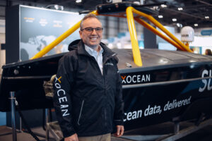
His 10 years of working at sea included tours in Alaska, the Pacific, and the Atlantic and Gulf coasts and four years as the Commanding Officer and Chief Scientist of the NOAA Ship Thomas Jefferson. In his final role with NOAA, he served as Director of the Office of Coast Survey, where he oversaw the US national programs in hydrography and nautical cartography. Smith also represented the United States at the International Hydrographic Organisation and regional hydrographic commissions.
CEO James Ives commented:
“We’re delighted to welcome Shep to the XOCEAN team. Throughout Shep’s career, he has continually pushed the boundaries of ocean technology, and we’re really excited to have him leading the next phase of our technical journey. Above all, we share the same vision of transforming ocean data through technology with the purpose of supporting the sustainable growth of the ocean economy.”
“XOCEAN’s vision and ambition has appealed to me from the very beginning.” said Smith of his appointment. “Their USV technology has already caught the attention of the industry and the company’s aspirations are set to shake up seabed surveying further. It is critical that we harness the power of technology to support a low carbon maritime sector—XOCEAN will be key to this sustainable future. I’m excited to be part of this innovative organisation and to support the team in bringing their forward-thinking ideas to the market.”
Smith will be responsible for propelling XOCEAN to its next phase of growth: developing XOCEAN’s technology roadmap, advancing the boundaries of Uncrewed Surface Vessel (USV) tech, and driving the technical vision for the business.
XOCEAN uses its proprietary marine robotic technology to collect ocean data sustainably across a range of industries, including offshore wind. XOCEAN has successfully delivered over 100 projects, accumulating over 35,000 hours of operation and offsetting over 45,000 tonnes of CO2. XOCEAN serves the growing demand for carbon-neutral data collection, using satellite controlled uncrewed vessels developed in-house. The company is headquartered in Ireland, with offices in the UK, Canada, Norway and most recently the US.
XOCEAN’s ambitious technology roadmap will integrate new capabilities into the USV, maximising the efficiency of the platform, and mapping deeper waters. The company’s mission is to push the boundaries of technology for the benefit of their clients, the industry, and the environment.
To learn more about partnering with XOCEAN email [email protected] or visit xocean.com

New Stainless Cousin for Snow Catcher Family
Global marine systems manufacturers Ocean Scientific International Ltd (OSIL) have announced a new addition to their Marine Snow Catcher / Microplastics Sampler family.
These samplers can facilitate a greater understanding of the export processes of the oceanic organic carbon and nutrient cycles, and can help to predict how these processes may change in the future, as well as providing an insight into the extent of oceanic microplastics in the water column. The range now includes samplers with the option of fully Stainless Steel settling volumes to help reduce the potential for cross contamination specifically for users wishing to study microplastics.
The Marine Snow Catchers are large volume water samplers which possess separable top and bottom sections. These modular sections allow researchers to collect and characterise suspended and sinking particles in the water column, as the samplers are allowed sufficient time on deck following recovery to permit sinking particles and aggregates to collect in the bottom chamber before the overlying water is drawn off from the top portion. The bottom section can then be removed separately for recovery, study and analysis of the accumulated samples, which is aided by the flat-bottomed design of the chamber.
The internal design of the sampler reduces turbulence and eliminates issues with pressure waves associated with towed net systems which can result in over/under reporting of concentrations.
The Marine Snow Catcher range boasts three sizes; 50L, 100L or 300L, and is now available in either the traditional PVC or the new Stainless Steel options.
For further information or sales enquiries please contact: [email protected] or call +44 (0) 2392 488 240.

Bright tide launces UK's most specialist Blue Economy ocean accelerator
To keep 1.5 degrees within reach, we need a healthy ocean and the Blue Economy was rightly a key topic at COP26. As the emerging ocean-innovation market continues to gain recognition, social enterprise and sustainability training outfit Bright Tide, has announced the launch of its first Blue Economy Ocean Accelerator Programme for SME businesses. The most specialist of its kind in the UK, it’s free to apply to and take part in. Applications are open for submissions from 15th March to 15th April 2022 and a final 10 successful businesses will make it through.
Bright Tide is on the hunt for exciting SME businesses within the field of ocean-impact innovators to take part, from food producers using ocean sourced ingredients such as seaweed, through to sustainable fisheries, aquaculture, shipping, offshore wind and beyond.
Founder and director of Bright Tide, Harry Wright, said:
“By moving human activities which directly impact and depend on the ocean towards being more sustainable, we can rebuild ocean prosperity and restore biodiversity. Activities such as shipping, fishing and marine renewable energy need to rapidly transition into a sustainable blue economy, however currently this remains exceptionally underfunded. This was the motivator behind us launching our biggest ever accelerator programme for ocean-impact innovators. We’re proud to be supported by founding sponsors at The University of Plymouth and Investec Wealth & Investment, and we can’t wait to see the exciting businesses that apply to take part.”
Adrian Dawson, Director of Research and Innovation at the University of Plymouth, said:
“As the world’s leading marine research university, we are delighted to be a founding partner in this innovative Blue Economy Ocean Accelerator Programme. Our Marine Institute represents the broadest spectrum of academic expertise anywhere in the country, but collaborations with industry are essential if we are to develop effective and lasting solutions to the challenges facing our ocean. This programme offers genuine potential to create new and exciting connections with those SMEs working in the blue economy and contributing to the socioeconomic value of pristine marine environments and biodiversity.”
Stacy Parrinder-Johnson, chief investment officer at Investec Wealth & Investment, said:
“We believe the climate crisis poses a significant threat to the global economy and society. In addition, our business is always looking to work with partners who are change-makers, disruptors and out-of-the-box thinkers. So we are thrilled to have the opportunity to support an important initiative which is looking to find exciting, and potentially transformative, businesses in the field of ocean impact.”
Despite current underfunding of the ocean innovator sector, a 2020 report from the High Level Panel for a Sustainable Ocean Economy (the Ocean Panel), indicated the investment return on the sustainable ocean economy over the next 30 years is 500%, meaning every $1 invested in sustainable ocean solutions returns at least $5 in global benefits.
Ten successful businesses will ultimately secure places on the 8-week programme which will offer between 5-10 hours a week of dedicated support including 1 to 1 tailored expert individual mentorships with industry experts, group mentorship sessions, peer-to-peer learning, commercial pitching opportunities, workshops and access to professional networks. Shortlisted businesses will also take part in exclusive in-person industry meet-ups with the programme’s corporate and blue economy partners, professional networks, peer-to-peer circles and scientific academic partners, and will have the opportunity to pitch at its Meet-The-Buyers event in London. This community and eco-system building element will be a key part of the programme, which is geared towards building game-changing contacts in the industry for all finalists. Beyond this, the programme will offer technical support to help ocean ventures scale up their commercial aims with leading experts, including access to pro bono support, including legal, investment readiness, tax, scientific advice and impact measurement.
Bright Tide’s Blue Economy Ocean Accelerator Programme is sponsored by The University of Plymouth and Investec, as well as enjoying a number of well-known in-kind supporters.
To find out more and apply to Bright Tide’s Ocean Accelerator Programme, visit https://www.bright-tide.co.uk/blueeconomy.

Miros’ RangeFinder supports safe operations at two ports in Vietnam
- Environmental monitoring systems provider to deliver increased safety and efficiency through its RangeFinder technology -
Miros, in association with Reecotech, its partner in Vietnam, has been awarded two separate contracts to support major industrial projects with its RangeFinder solution.
The Miros RangeFinder is a dry, radar-based sensor measuring airgap, tide, water level, draught, and waves, offering millimetre accuracy in all weather conditions. The sensor, which was chosen for its ability to reliably deliver high data quality, will be implemented as part of tailored automated weather and sea monitoring systems.
The first contract with Long Son Petrochemical Complex Project (LSPCL) involves the construction of a large greenfield petrochemical complex on Long Son Island in Vietnam. The $5.4 billion project involves a power plant as well as supporting infrastructure. As it requires intensive ocean data monitoring during the operational phase, Reecotech will supply an automated ocean and meteorological monitoring system integrating the Miros RangeFinder Ex.
The enhanced system, which is suitable for use in hazardous, potentially explosive areas, can supply highly accurate and reliable weather and ocean data whilst complying with national safety requirements. RangeFinder Ex is certified to Atex IECEx standards for areas where an explosive atmosphere consisting of a mixture with air or flammable substances is likely to occur in normal operation.
The second contract will see Miros supporting Hoa Phat Group, a leading steelmaker in Vietnam, which is developing a new integrated steel and iron production complex in the central province of Quang Ngai. The project, valued at more than $2 billion, includes a deep-water port system which will allow heavy ships of up to 200,000 tons to dock as they are transporting raw materials and finished steel products globally.
Miros RangeFinder was chosen to support port safety and efficiency by providing real-time measurements with millimetre accuracy of airgap, water level, tide, and non-directional wave parameters, including the measurement of wave periods longer than 120 seconds.
Emilie Dorgeville, VP Business Development, Ports & Renewables, commented:
“We are perfectly placed to support these two major projects in Vietnam. As RangeFinder allows for internal depth-to-water sampling at up to 200Hz and results output at up to 50Hz, the high data rate provided is extremely helpful in avoiding any observation errors.
"Since our RangeFinder Ex is fully certified for use in Zone 1, it is the ultimate sensor to deliver accurate, real-time measurements of water level, tide, and air gap measurements in hazardous areas. The RangeFinder and RangeFinder Ex deliver a reliable extra layer of safety providing wave data with incredible accuracy for improved port efficiency.”
Hai Minh Tran, Managing Director of Reecotech, added:
“We are delighted with the quality of real-time data that RangeFinder can provide our clients. The system is cloud-integrated, robust, and reliable, allowing port authorities and investors to accurately assess and take the necessary actions to minimise risks associated with project implementation and port operations.
“We trust RangeFinder as it has proven its ruggedness and reliability through decades of service in extreme weather conditions all over the world.”