
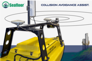
Seafloor Collision Avoidance Assist
Seafloor is proud to announce the availability of an industry-disrupting Collision Avoidance Assist (CAA) package for integration on future unmanned survey vessels. The system's main components include an onboard computer and LiDAR to navigate around both stationary & moving objects. Our point cloud 360-based system detects and tracks objects in real time within a standard 25m radius. The introductory-level system reduces human navigation errors, increases data acquisition efficiency, and overall - protects survey instruments during missions. Our engineers have configured the CAA system to be modular, so that future software iterations and instruments can be added depending on the desired level of function. Currently, there is no other low-cost collision avoidance package on the market that can be mounted into mid-sized unmanned vessels like the EchoBoat-160 and EchoBoat-240. This development brings heightened hands-off capabilities to our line of survey vessels so more focus can be directed towards collecting precision hydrographic data.
CAA Highlights:
• Integrated into AutoNav autopilot system, only basic knowledge of mission
planning needed
• No additional control software required
• Can be integrated into alternative control systems
• Leverages LiDAR point cloud clustering to gain a true representation of the
environment
• IP67+ LiDAR provides a dense 3D depth map
• Global cloud integrated software distribution platform allowing for Over-The-Air
updates of core software and machine learning elements
• Adjustable avoidance reaction distance
• 25m standard
• 50m available with alternate higher-density LiDAR
• Powerful NVIDIA computer with integrated GPU handles processing
• World's leading platform for AI at the edge
*Responsibility for the Proper Operation of Your Vessel:
CAA (Collision Avoidance Assist) performs the functions of obstacle avoidance designed for use in compatible vessels. While using CAA, it is your responsibility to ensure that you follow
instructions for use of service and exercise good judgment. Access to and use of CAA is at your own risk and responsibility, and CAA should be accessed and/or used only when you can do so safely. CAA does not alleviate the need for human in the loop observation. It is designed to assist the vessel operator who must remain aware of navigation and surroundings at all times. Vessel must be operated by a fully attentive driver that is prepared to take over at any moment.

Join the Chesapeake Technology team for our winter 3-Day Training Workshop to learn the newest SonarWiz 7 features.
COLLEGE OF CHARLESTON, SC
Join the Chesapeake Technology team for our winter 3-Day Training Workshop to learn the newest SonarWiz 7 features. This will be an in person event held at College of Charleston, South Carolina USA.
The Chesapeake Winter training event is dedicated to creating and maintaining a safe and healthy environment in compliance with guidance from state and local governmental agencies and the College of Charleston
The safety guidelines outlined below are in place and subject to change:
- Our guidance recommends everyone wear a face covering in indoor public settings, whether you’ve been vaccinated or not.
- We encourage all in-person attendees to be vaccinated.
- Masks will be provided as needed.
- Hand sanitizer stations are located throughout the facility for your use.
- Approved food and beverage preparation and service procedures will be followed for the health and safety of all attendees.
- We ask that all attendees to confirm that they are not displaying symptoms of COVID-19 and have not recently been exposed to anyone who tested positive. If you do have symptoms or have been exposed, your registration fee will be refunded, or can be applied towards another event.
Attendees will learn to use SonarWiz for sidescan, sub-bottom, multibeam, single beam, and magnetometry processing. Learn advanced interactive planning tools and processing techniques to create 3D images, conduct textual analysis using the advanced seabed characterization tools, and increase productivity using the 3D area and swath based editing tools, and much more.
Training includes a 14 day demo license, reference guides and sample data sets to use SonarWiz during and after class. Training will be held 9:00am - 5:00pm EST.
- 9am - 1pm (classroom) ; 2pm - 5pm (on the water) Pickney room
- Edgetech sonar systems using SonarWiz
- 1pm - 5pm - Introduction to SonarWiz
- A short session on the program basics for beginner users
- 6pm - 8pm - Partner Reception
- 8am Pre-registration
- 3pm - 5pm - meet with partners, one-on-ones, boat demos
- 5pm - 7pm - Reception in Atrium, open to all
- 3pm - 5pm - meet with partners, one-on-ones, boat demos
- 5pm - 7pm - Evening social sponsored by Survey Equipment Services (SES)
- 3pm - 5pm - meet with partners, one-on-ones, boat demos
Registration is $695 per person or $590 with a current EMA. Companies pay $1,995 for up to 4 attendees. Students pay $349 or call for group discounts. Attend for free if you purchase a SonarWiz license within 60 days of the course.
We have arranged a group discount rate of $149 per night at Francis Marion Hotel . Please click on this link to reserve your room and use "CHESAPEAKETECH21 to ensure that you receive this discounted group rate.
If you have any questions please call us at +1 650-967-2045 or email [email protected].
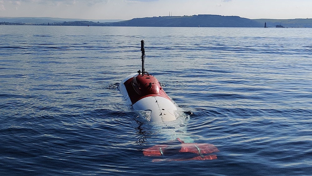
Sonardyne and Wavefront demonstrate obstacle avoidance capability on UK’s test XLUUV
Underwater obstacle avoidance technology from maritime defence technology companies, Sonardyne and Wavefront, has been successfully demonstrated on board an extra-large, uncrewed, underwater vehicle (XLUUV) built and operated by Plymouth-based MSubs Ltd.
The demonstration of the Vigilant forward looking sonar was part of the first phase of the UK’s Defence and Security Accelerator’s (DASA) ‘Uncrewed Underwater Vehicle Testbed – Opportunity to Integrate’ competition, run jointly with the Royal Navy and the Defence Science and Technology Laboratory (Dstl).
The DASA competition is focused on testing and validating commercial-off-the-shelf technologies (COTS) sensors and payloads, like Vigilant, to help the Royal Navy understand the future roles for XLUUVS for surveillance, reconnaissance and anti-submarine warfare, and deliver new capabilities to the Royal Navy years earlier than otherwise be possible.
Vigilant, developed by Wavefront and manufactured and commercialised by Sonardyne, is a navigation and obstacle avoidance sonar for ships, uncrewed surface vessels (USVs) and underwater vehicles. It provides crews with automated long-range detection of objects in the water column, showing them where it is safe to navigate and alerting them to potential underwater dangers that could result in a collision or grounding.
The system has two operating modes. In 3D mode, Vigilant produces accurate 3D bathymetry and colour-coded depth imagery out to 600 m and to depths down to 100 m. In Sonar mode, Vigilant processes the intensity of the acoustic data to extract long-range positional data out to 1.5 km and over a 120-degree field of view. The sonar returns are used to generate alerts highlighting the presence of a navigationally relevant obstacle.
For the trial, the system’s sonar projector and receiver array were mounted in the bow of the 9 m-long MSubs’ S201 XLUUV. At just 31 cm-wide and weighing only 14 kg in air, Vigilant is easy to retrofit on a wide range of platforms including ships, USVs or, as in this case, an XLUUV.
As part of the demonstration, the XLUUV was programmed to travel beyond the breakwater outside Plymouth sound. Vigilant was used to create a bathymetric map that was used by the XLUUV to navigate. The data was also overlaid over existing charts of the area, demonstrating the higher resolution provided by Vigilant.
Ioseba Tena, Head of Defence at Sonardyne, said: “We’re delighted to be playing a role in helping the Royal Navy and programme partners to test and evaluate technologies that will help the UK stay ahead of her adversaries in the underwater battlespace.
“Seaborne collision avoidance is a vital consideration for autonomous and uncrewed naval platforms. Vigilant can be integrated into these ocean robots to provide essential information to autopilots and command and control systems, to aid safe navigation and manoeuvres around hazardous obstacles.”
Bret Phaneuff, Managing Director at MSubs, said:
“The data from Vigilant is truly impressive and transformative. It provides our XLUUV with instant situational awareness, which will help it avoid obstacles and, with some further integration, help optimise navigation trajectories to improve our performance and increase our endurance.”
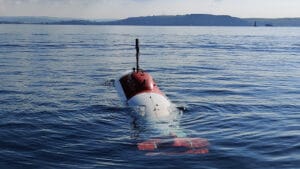
Image Caption: The MSubs S201 XLUUV is being trialled by the UK’s Royal Navy to explore the potential capabilities of large uncrewed underwater vehicles for its future missions.
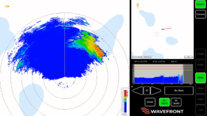
Image Caption: 50 m deep, 16 km south of Plymouth, the vehicle can be seen navigating around an area of shallow water to the north.
SAAB Seaeye's new underwater robot to join Ocean Infinity Armada
A contract has been signed with launch customer Ocean Infinity for 10 of the latest Saab Seaeye underwater robots, supporting new jobs and site expansion.Saab Seaeye, a world leader in underwater robotics, has agreed a deal to sell 10 of its new electric work remotely operated vehicles (eWROV), including further options, to leading marine robotics company, Ocean Infinity.
Due to this and further future contracts Saab Seaeye is also to expand by 70% to an additional 3,236m2 (34,832 ft2) site in Fareham, UK, by March 2022 and is currently recruiting.
The new eWROV product, is the world’s most capable and intelligent all-electric, work-class underwater robot, that will be built in Saab Seaeye’s new facility in Fareham within the Solent Freeport.
The eWROV is the latest addition to Saab Seaeye’s underwater portfolio used across a variety of offshore energy sectors, ocean science and defence. It is the culmination of four years of research and development, resulting in a larger and more powerful ROV compared to those designed for light work and observation tasks.
Saab Seaeye is among the first companies to produce a full-size electric work-class vehicle that can deliver the same overall performance as a 250 horsepower hydraulic vehicle, while offering a lower lifetime cost and reduced environmental impact.
Ocean Infinity is developing the world’s largest fleet of uncrewed robotic vessels and will be the eWROV’s launch customer. The eWROV will play its part in Ocean Infinity’s mission to use innovative technology to transform operations at sea, enabling people and the planet to thrive. Armada is set to revolutionise the maritime industry, delivering sustainable services that offer up to 90% emissions savings over a conventional vessel performing a similar offshore task.
The eWROV’s electrification is the key to its improved performance and sustainability-related attributes. As well as being more efficient, electric systems use little or no oil, making the eWROV significantly more environmentally friendly than equivalent hydraulic work-class systems.
Most important, eWROV benefits from Saab Seaeye’s iCON™ intelligent system architecture, making it capable of fully autonomous operation.
“Ocean Infinity’s order is the largest in Saab Seaeye’s history and highlights the need for intelligent, adaptable and flexible underwater robotics. The eWROV is more efficient and cleaner than the hydraulic alternatives and it also requires less human involvement and will play an important role in future autonomous vessel fleets. We are confident the eWROV will serve Ocean Infinity well,” says Magnus Lewis-Olsson, Chairman of Saab UK.
“Lessening the environmental impact of operations at sea is the main driver behind the development of Armada. The all-electric eWROV, in addition to our already low-emission vessels, will enable us to support our customers with infrastructure integrity projects in the most environmentally responsible way. The eWROVs will form an important part of our Armada architecture; through integration with our dynamic payload controller, we’ll be able to deploy and operate them anywhere in the world from our Remote Control Centres,”
says Dan Hook, Chief Technology Officer, Ocean Infinity.
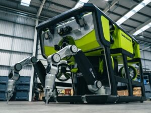
Saab Seaeye’s new eWROV is the world’s most capable and intelligent all-electric, work-class underwater robot.
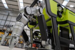
The new robot is fitted with Saab Seaeye’s all-electric seven-function high-precison manipulators.
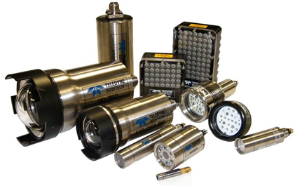
Teledyne Marine partners with Seatronics to increase distribution of Bowtech cameras and lights range in Europe, Americas, and Asia Pacific
Teledyne Marine are pleased to announce the appointment of Seatronics Group, an Acteon company as a distribution & service partner for its market leading Bowtech brand of underwater cameras, lights and underwater strobes.
Seatronics will not only add to Teledyne’s existing distribution sales network by making products more accessible to the market but also strengthen after-sale care around the globe making use of its regional service centres in UK, Singapore and USA.
“Imaging technology is the at heart of Teledyne’s business and since its acquisition in 2015, the Bowtech brand has formed a vital offering within our portfolio of underwater positioning, imaging and communication sensors,” William Egan, VP Sales & Marketing at Teledyne Marine, Imaging & Instruments. “With a long and positive track record of sale, rental and integration of Bowtech cameras and lights, Seatronics were a natural choice for Teledyne as we look to further increase global distribution for this successful range, be closer to our customers and continue to enhance the customer experience.”“Seatronics are delighted to announce this formal partnership with Teledyne Marine in support of the Bowtech brand” added Derek Donaldson, Managing Director of Seatronics. “It is great to see Seatronics leveraging our wider platform for sales and service for the Bowtech products globally from our Aberdeen, Houston and Singapore sites.”
For more information please contact Ed Cheesman, Sales and Business Develop Sr. Manager, Teledyne Marine at [email protected]
ABOUT TELEDYNE MARINE:
Teledyne Marine is a group of leading-edge subsea technology companies that are part of Teledyne Technologies Incorporated. Through acquisitions and collaboration, Teledyne Marine has evolved into an industry powerhouse, bringing Imaging, Instruments, Interconnect, Seismic, and Vehicle technology together to provide total solutions to our customers. www.teledynemarine.com
ABOUT SEATRONICS:
Seatronics, an Acteon company, are a global leader in the rental and sale of marine electronics equipment and subsea solutions. Their capabilities include custom sensor solutions; subsea electronics equipment rental; service repairs and calibration support; lightweight observation remotely operated vehicles (ROV); and ROV tooling, all built in partnership with key equipment manufacturers. As a single-source partner, Seatronics provides access to multiple and exclusive, global supplier partnerships, sourcing the best and latest technology available.
www.seatronics-group.com
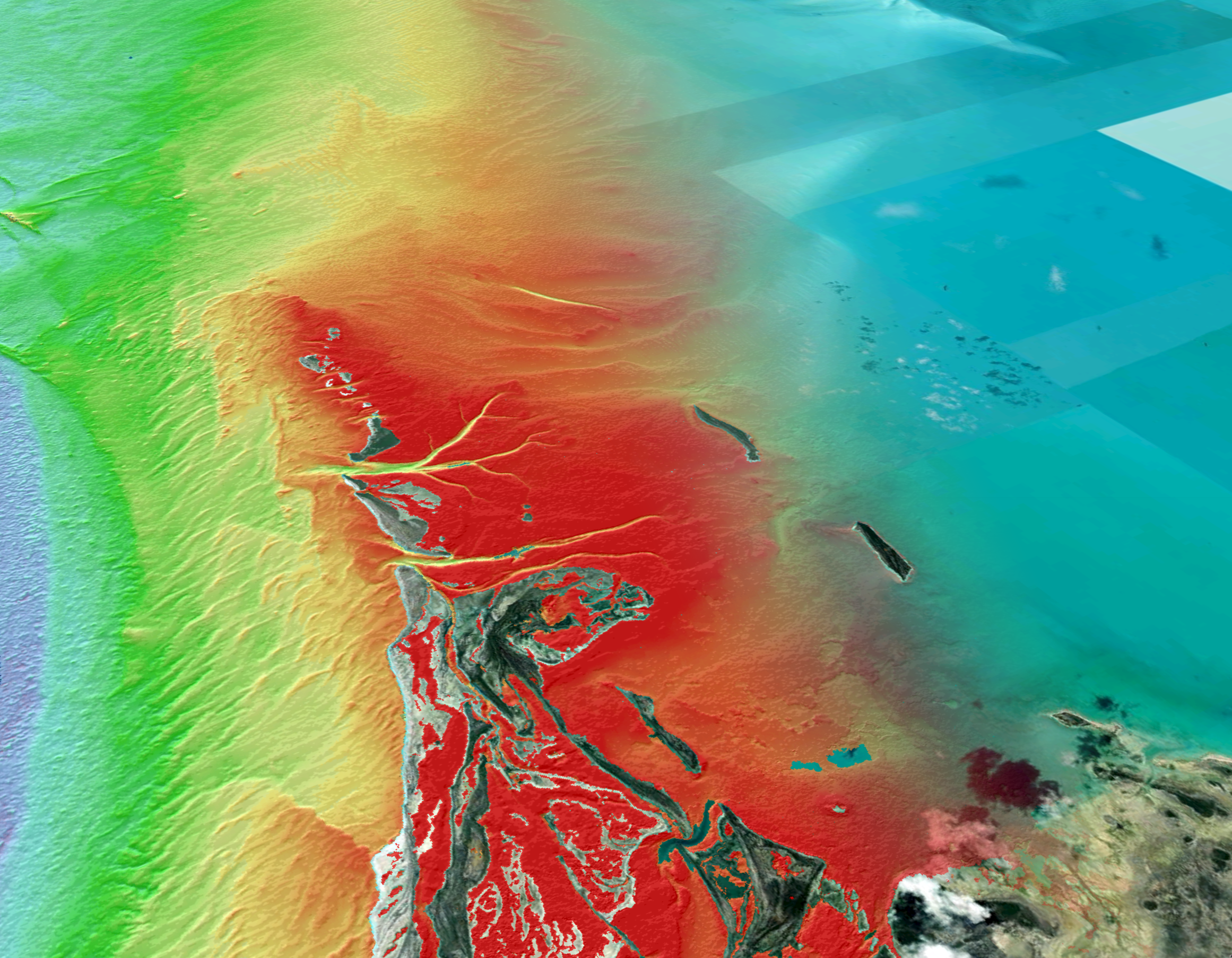
The Nippon Foundation-GEBCO Seabed 2030 Project Announces Partnership with TCarta
As the effort in pursuit of the complete map of the ocean floor accelerates, The Nippon Foundation-GEBCO Seabed 2030 Project signs a new Memorandum of Understanding (MOU) with TCarta Marine, LLC (TCarta) – a US-based company dedicated to marine remote sensing and hydrospatial data services.
Seabed 2030 is a collaborative project between The Nippon Foundation and GEBCO to inspire the complete mapping of the world's ocean by 2030, and to compile all bathymetric data into the freely available GEBCO Ocean Map. GEBCO is a joint project of the International Hydrographic Organization (IHO) and the Intergovernmental Oceanographic Commission (IOC) and is the only organisation with a mandate to map the entire ocean floor. Seabed 2030 is formally endorsed as a Decade Action of the UN Decade of Ocean Science for Sustainable Development.
TCarta has been a global innovator in Satellite Derived Bathymetry (SDB), marine remote sensing and space-based hydrospatial technologies since its founding in 2014. The company has extensive experience producing custom, project-specific SDB, as well as en masse through automation and cloud computation.
TCarta is currently underway in grant research, funded by the National Oceanic and Atmospheric Administration (NOAA) to pursue advancements in on-platform parameterization of satellite imagery collection for improved SDB data, as well as to develop standards of SDB, next-generation assessments of data accuracy, and definitions of zones of confidence.
“With just over 20 per cent of the seafloor mapped, we are aware of the significant task ahead of us – mapping the remaining 80 percent of the seafloor in under ten years,” commented Jamie McMichael-Phillips, Project Director of Seabed 2030. “However, at Seabed 2030 we subscribe to the view that with global cooperation, producing a complete map of the entire seafloor within our timeframe is achievable. We are therefore delighted to welcome the support of TCarta in helping us realise our goal.”
Commenting on the partnership, President of TCarta Kyle Goodrich said, “At TCarta, we recognize the need for a complete map of the seafloor and especially in vulnerable and dynamic coastal areas.
“We are very excited to bring TCarta’s vision for scalable, global satellite-based surveying technology, developed under our National Science Foundation Small Business Innovation Research grant, to participate in this important global initiative.
“TCarta looks forward to this partnership in striving for Seabed 2030 goals by contributing bathymetric data to in-fill the data gaps in existing hydrographic survey coverage.”
All data collected and shared with the Seabed 2030 Project is included in the GEBCO global grid, which is free and publicly available.
For more detailed information on The Nippon Foundation-GEBCO Seabed 2030 Project, please visit our website, seabed2030.org, like our Facebook page, follow us on Twitter @Seabed2030, or contact [email protected].
The Nippon Foundation-GEBCO Seabed 2030 Project is a collaborative project between The Nippon Foundation and GEBCO. The Seabed 2030 Project, launched at the United Nations Ocean Conference in 2017 by Chairman Sasakawa of The Nippon Foundation, coordinates and oversees the sourcing and compilation of bathymetric data from different parts of the world’s ocean through its five centres into the freely-available GEBCO Grid. Four Regional Centres cover the Southern Ocean, the Arctic and North Pacific Ocean, the Atlantic and Indian Oceans, and the South and West Pacific Ocean. These feed data products into the Global Data Centre. Find out more about the project and how to get involved.
Pegah Souri
[email protected]
+44 (0)7951 581707
TCarta Marine, LLC (TCarta), a Denver, CO-based, independently owned small business with a mission to survey the seafloor utilizing space-based instruments and a vision for globally-produced, multi-source Satellite Derived Bathymetry solutions for coastal, littoral and lacustrine surveying. Find out more about TCarta here.
Kyle Goodrich
[email protected]
+1 (303) 284-6144
Impactful USV investment for GEOSIGHT
Specialist survey contractor GEOSIGHT is a multi-disciplinary geospatial survey company which has established its reputation for quality since its entry into the market in 2016. The environmentally minded
firm delivers survey projects in some of the UK’s most precious and environmentally-sensitive inland waterways such as the Norfolk Broads, and as a company is firmly committed to using modern,
cutting-edge equipment and techniques to deliver precise and accurate survey data.
The company’s environmentally centric approach and deployment of the latest survey technology combine in GEOSIGHT’S latest announcement of their first order for an Uncrewed Surface Vehicle (USV) from HydroSurv Unmanned Survey (UK) Ltd scheduled for delivery early next year.
New for 2021, the REAV-28 is a 2.8m USV platform of catamaran hull form with a fully-electric propulsion system, which may be deployed and recovered from foreshores and beaches for a range of hydrographic and environmental survey applications. Based on HydroSurv’s smaller REAV-16, the larger vehicle has improved open-water sea-keeping and a more powerful propulsion system with greater endurance. In addition, the USV has a fully-integrated SVP winch and a series of enhanced and new control features.
The latest investment will enable GEOSIGHT to reduce the carbon emissions of its survey operations and offer a non-invasive survey acquisition tool which may be used in the presence of environmentally sensitive receivers. Additionally, the USV will reduce the need for surveyors to work afloat and reduce costs of mobilisation and operations, enabling GEOSIGHT to pass on increased value to its customers. “Having thoroughly researched the market, GEOSIGHT have found the right partner in HydroSurv, to move
forward with, and look forward to allying the REAV-28 with our NORBIT iWBMS high-resolution multibeam echosounder.” Brian Gamet, Principal Surveyor, GEOSIGHT.
“We’re excited to be working with Brian and his team at GEOSIGHT on this new REAV-28, which brings with it a series of new capabilities for HydroSurv’s smaller USV platforms. Working in close collaboration with GEOSIGHT will enable us to draw upon their hydrographic survey expertise and deliver a best-in-class
solution for readily-portable USVs.” David Hull, Founder & CEO, HydroSurv.
About HydroSurv
HydroSurv is a global innovator in Uncrewed Surface Vehicles (USVs) to democratise marine geospatial
data for the ocean industries. With a range of electric and hybrid USVs from 1.6 - 5.7m for inland,
nearshore and offshore operations, HydroSurv delivers a blended offering of USV platform sales, leasing,
design engineering and ‘Robotics as a Service’.
About GEOSIGHT
Established in 2016, GEOSIGHT has evolved to become a team of professional geospatial surveyors
providing clients with precise and accurate dimension data of both the built and natural environments on
both land and sea using modern, cutting-edge equipment and techniques. GEOSIGHT has built its
reputation on professionalism, efficiency and quality and is regulated by the Royal Institution of Chartered
Surveyors (RICS), holds membership of the UK Survey Association as well as employee accreditation with
the RICS and Chartered Institution of Civil Engineering Surveyors (CICES).
Contact details
HydroSurv Unmanned Survey (UK) Ltd
David Hull | Chief Executive
[email protected]
GEOSIGHT
Brian Gamet | Managing Director
[email protected]
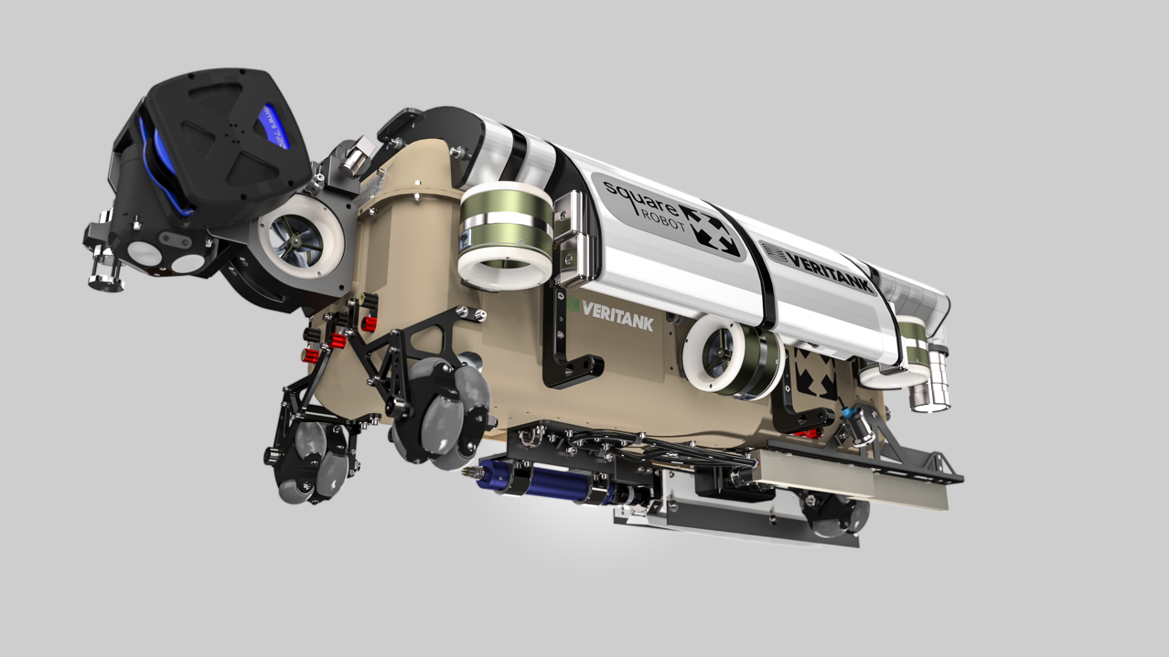
Bringing navigation accuracy to tank inspection robots deployed in a harsh environment
A pioneering autonomous robot with a high-performing DVL is revolutionizing fuel tank inspection – while eliminating potential operational hazards.
Nortek’s Doppler Velocity Logs (DVLs) are already established as industry-leading instruments for velocity calculations in subsea applications. But pioneering Boston-based company Square Robot has now successfully deployed them in a very different and challenging environment.
Square Robot is helping to change the face of the oil and gas industry through its development of an innovative robot that can provide detailed assessments of the conditions in above-ground petroleum storage tanks.
Using the robot eliminates the need to empty the tanks of liquid so that humans can enter to carry out detailed inspections – a costly, time-consuming and potentially hazardous procedure still used in most tank assessments.
Founded in 2016, the company took just two years to design and build a highly robust autonomous robot certified to operate in these hazardous environments. Five versions of the robot are now being deployed by leading firms in the US petrochemical storage sector.
Robust autonomous robot for fuel storage tank inspections
The “Square Robot”, from which the company takes its name, is essentially a highly robust, autonomous robot laden with sensors, able to fit through the 24-inch “manway”, the standard-size portal fitted to the top of storage tanks.
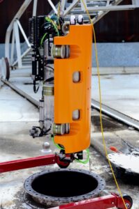
The Nortek DVL1000 leads the way as the inspection vehicle enters a tank. The DVL operates to a high degree of accuracy in the harsh environment inside.
The robot is then able to navigate through the liquid-filled tank – typically gasoline or diesel – to detect damage such as corrosion on the tank floor. The tanks, a familiar sight for many, are typically 10–30 m tall and 15–80 m in diameter.
“The robot essentially performs a floor inspection of the tank that would otherwise have to be done by a human,” says Amy Underwood, Senior Roboticist at Square Robot.
“During a traditional out-of-service inspection, the tank is emptied, cleaned to make it safe for entry, then inspected by personnel. All of this downtime means a significant loss of revenue for the tank owner. Our robot gets rid of all that – your tank is still in service and full of product,” she says.
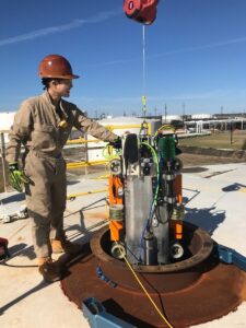
Roboticist Amy Underwood lowers the Square Robot through a 24-inch manway into a petrochemicals-filled storage tank.
The vehicle is innovative in that it carries out tests in a way that won’t damage the tank – so-called non-destructive testing (NDT) – using technologies such as ultrasonic testing (UT), which can characterize the thickness and internal structure of a surface using high-frequency sound waves. Additionally, the robot is capable of hovering, unlike “crawler” robots sometimes used for basic inspections.
Highly accurate velocity measurement for precise positioning of robot
But in order to precisely examine and map areas of concern, the robot needs to know exactly where it is in the tank. That requires highly accurate velocity measurement to aid navigation in a critical way – neither of which is straightforward in an enclosed tank full of liquid product.
The Square Robot vehicle with the four-transducer Nortek DVL1000 mounted at the extreme left. The vehicle deploys ultrasonic testing, HD cameras and other non-destructive methods to assess tank wear and tear; the assessment depends on the DVL for pinpoint positioning.
To solve the problem, the company looked to its roots in the subsea industry. Square Robot’s founders and several other team members previously worked at a leading AUV developer and have had long careers in the subsea industry. So, they already knew what worked well for velocity measurement in the ocean and wondered whether it could be made to work in the harsh environment of a storage tank.
“We needed high navigational accuracy, and knew DVLs could provide this from our background in subsea,” says Underwood.
DVLs use the Doppler effect to calculate velocity by measuring the shift in wavelength between acoustic pulses transmitted to and reflected back from particles in a liquid or a surface such as a seabed.
The team were familiar with Nortek’s Doppler velocity logs, which had a reputation for being highly accurate, reliable and straightforward to use for underwater navigation, as well as offering the compact form needed to fit into the restricted space of the robot.
Crucially, Nortek’s 1 MHz DVL1000, the instrument Square Robot decided on, could operate accurately at a distance of only around 20 cm from a given surface – often the seabed, but in this case the tank floor. That is closer to the floor than many other DVLs on the market are capable of operating accurately, and a prerequisite for the inspection vehicle to do its job properly.
The fact that this DVL performs so well in such a difficult environment can be attributed to Nortek’s proprietary bottom-tracking algorithm.
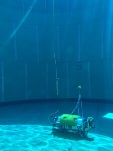
Testing the Square Robot vehicle in a test tank filled with water. The DVL1000, seen on the right, is mounted so it can work unobstructed, while maintaining a minimum distance from the floor.
A DVL operating accurately at even smaller distances from the floor
While the Nortek DVL already works closer to a surface than many other instruments on the market, Square Robot is looking forward to technological advances now being rolled out by Nortek, which will enable it to operate accurately at even smaller distances from the floor.
Meanwhile, Square Robot is seeking to expand its operations both in the US market, where it currently operates, and internationally. The robot is currently deployed through Square Robot’s subsidiary inspection services company Veritank.
The company’s five models of the robot have differing, customizable payloads, which could be adapted for a number of uses, including subsea inspection and in the shipping industry.
“We’re focused on tank inspections right now, but we’re looking at alternatives and we’re always open-minded. Our goal is to be the best in whatever space we’re in,” says Underwood.
The successful use of the DVL in this novel environment is further evidence of the accuracy, reliability and versatility of one of Nortek’s most popular and recognized technologies.
SUT launches introduction to offshore Geophysics & Geotechnical engineering virtual courses
he Society for Underwater Technology (SUT) has launched a virtual introductory course on offshore site investigation and geotechnical engineering in the offshore environment. This is the online equivalent of the face-to-face course successfully run by the Society’s Offshore Site Investigation Group (OSIG) for a number of years. The online course is spread over four half days for two weeks (Tuesday and Thursday mornings) on 16, 18, 23 and 25 November.
Aimed at non-specialists, it aims to provide a broad overview of the offshore market, and how the data acquired is applied to maximise the value of offshore projects in both the offshore oil and gas and offshore renewable energy sectors.
The face-to-face course has built a formidable reputation explained Chery Burgess, CEO of the SUT:
“The face-to-face course has been running for 25, or so, years and has attracted well in excess of 500 delegates. We are delighted to add an OSIG course to our virtual offerings which also include our Virtual Subsea Awareness Course and an Introduction to Offshore Wind Energy Course, both of which have attracted delegates from around the world.
“The first two days of the OSIG course have a geophysical theme, and then in week two the attention turns to the geotechnical side of things. We have an impressive list of industry and academic experts covering a wide range of topics, from planning an offshore site investigation through technical and operational aspects of data acquisition and reporting, to the practical use of the data in geohazard assessment and foundation design.
“Our speakers are drawn from Vysus, MCL Consultancy, RPS, Bangor University, RWE, BP, University of Southampton, Gardline, Ørsted, NGI, University of Bristol, Atkins, Subsea 7, and Lloyd’s Register. Our thanks are extended to Francesca Ciavaglia of Lloyd’s Register who has co-ordinated preparation of this course.“
Each half-day session will include a set of oral presentations, followed by small-group practical activities with the scope to reinforce the knowledge and get further insight on the topics presented. Small-group activities will also provide an opportunity to discuss with experts in the field, while creating an engaging and interactive environment. Alongside knowledge sharing, the course provides an excellent opportunity to network within the offshore industry.
The course fee is £300 for SUT members and £395 for non-members. (excluding VAT where chargeable). Information on the CPD approved course is at https://www.sut.org/event/an-introduction-to-offshore-geophysics-and-geotechnical-engineering-3/. SUT individual membership is £76 per year. To join, visit www.sut.org or e-mail [email protected].
Fugro innovation delivers seabed Geo-data for South African port expansion
The Society for Underwater Technology (SUT) has launched a virtual introductory course on offshore site investigation and geotechnical engineering in the offshore environment. This is the online equivalent of the face-to-face course successfully run by the Society’s Offshore Site Investigation Group (OSIG) for a number of years. The online course is spread over four half days for two weeks (Tuesday and Thursday mornings) on 16, 18, 23 and 25 November.
Aimed at non-specialists, it aims to provide a broad overview of the offshore market, and how the data acquired is applied to maximise the value of offshore projects in both the offshore oil and gas and offshore renewable energy sectors.
The face-to-face course has built a formidable reputation explained Chery Burgess, CEO of the SUT:
“The face-to-face course has been running for 25, or so, years and has attracted well in excess of 500 delegates. We are delighted to add an OSIG course to our virtual offerings which also include our Virtual Subsea Awareness Course and an Introduction to Offshore Wind Energy Course, both of which have attracted delegates from around the world.
“The first two days of the OSIG course have a geophysical theme, and then in week two the attention turns to the geotechnical side of things. We have an impressive list of industry and academic experts covering a wide range of topics, from planning an offshore site investigation through technical and operational aspects of data acquisition and reporting, to the practical use of the data in geohazard assessment and foundation design.
“Our speakers are drawn from Vysus, MCL Consultancy, RPS, Bangor University, RWE, BP, University of Southampton, Gardline, Ørsted, NGI, University of Bristol, Atkins, Subsea 7, and Lloyd’s Register. Our thanks are extended to Francesca Ciavaglia of Lloyd’s Register who has co-ordinated preparation of this course.“
Each half-day session will include a set of oral presentations, followed by small-group practical activities with the scope to reinforce the knowledge and get further insight on the topics presented. Small-group activities will also provide an opportunity to discuss with experts in the field, while creating an engaging and interactive environment. Alongside knowledge sharing, the course provides an excellent opportunity to network within the offshore industry.
The course fee is £300 for SUT members and £395 for non-members. (excluding VAT where chargeable). Information on the CPD approved course is at https://www.sut.org/event/an-introduction-to-offshore-geophysics-and-geotechnical-engineering-3/. SUT individual membership is £76 per year. To join, visit www.sut.org or e-mail [email protected].