
Sequoia Scientific, Inc. Receives National Science Foundation Grant to Develop Carbon Uptake Sensor for Profiling Floats
Small Business Technology Transfer Program Provides Seed Funding for R&D Collaboration with the University of Maine School of Marine Sciences
Sequoia Scientific, Inc. has been awarded a National Science Foundation (NSF) Small Business Technology Transfer (STTR) Phase I grant for $254,110 to conduct research and development (R&D) work developing a bio-optical sensor for direct detection of sinking marine particles. Sequoia’s Vice President of Science and Technology, Dr. Wayne Slade, will lead the development as principal investigator, collaborating with Dr. Meg Estapa at the University of Maine, School of Marine Sciences.

Almost 4,000 ocean profiling floats are in operation globally. Hundreds of new floats are deployed each year, measuring a wide range of ocean science and climate change parameters. Scientists and policymakers are increasingly interested in measuring biogeochemical parameters that provide key data on biological ocean carbon uptake, which helps the ocean store carbon dioxide, but could be impacted by climate change. Within the scientific community, there is significant interest in development of new technology to measure the flux of carbon by particles settling out of the surface ocean. With the new NSF grant, Sequoia and UMaine will work on developing an “optical sediment trap” sensor that can directly measure the settling particles that carry the greatest amount of biological carbon into the deep ocean. The sensor will be small and power-efficient to address the challenges of multiple-year deployments from autonomous profiling floats and scaling to a global float array.
“NSF is proud to support the technology of the future by thinking beyond incremental developments and funding the most creative, impactful ideas across all markets and areas of science and engineering,” said Andrea Belz, Division Director of the Division of Industrial Innovation and Partnerships at NSF. “With the support of our research funds, any deep technology startup or small business can guide basic science into meaningful solutions that address tremendous needs.”
“Sequoia is honored to receive this grant that will lead to the development of a new sensor that will make a critical biogeochemical measurement – on a challenging platform – and will further our understanding of how climate change impacts the ocean. We are excited to collaborate with Dr. Estapa at UMaine, who is a leading researcher in understanding the biological carbon pump and particle flux,” said Dr. Slade.
“This new sensor is meant to take advantage of the rapid expansion in the number of profiling floats measuring biogeochemical processes,” said Dr. Estapa. “Sequoia is the ideal partner because of their track record in building underwater, optical particle sensors, and working with the scientists who use them.”
Once a small business is awarded a Phase I SBIR/STTR grant (up to $275,000), it becomes eligible to apply for a Phase II (up to $1,000,000). Small businesses with Phase II funding are eligible to receive up to $500,000 in additional matching funds with qualifying third-party investment or sales. During Phase I, Sequoia and University of Maine will focus on sensor optical, power, and fluid dynamics modeling. The modeling results will guide a series of laboratory test and prototype concept development. An actual prototype and in-situ test on deployed floats would be part of an eventual Phase II award (24 months duration) and a commercial instrument would be ready immediately after Phase II.
Startups or entrepreneurs who submit a written Project Pitch will know within one month if they meet the program’s objectives to support innovative technologies that show promise of commercial and/or societal impact and involve a level of technical risk. Small businesses with innovative science and technology solutions, and commercial potential are encouraged to apply. All proposals submitted to the NSF SBIR/STTR program, also known as America’s Seed Fund powered by NSF, undergo a rigorous merit-based review process. To learn more about America’s Seed Fund powered by NSF, visit: https://seedfund.nsf.gov/
About the National Science Foundation's Small Business Programs: America’s Seed Fund powered by NSF awards $200 million annually to startups and small businesses, transforming scientific discovery into products and services with commercial and societal impact. Startups working across almost all areas of science and technology can receive up to $2 million to support research and development (R&D), helping de-risk technology for commercial success. America’s Seed Fund is congressionally mandated through the Small Business Innovation Research (SBIR) program. The NSF is an independent federal agency with a budget of about $8.5 billion that supports fundamental research and education across all fields of science and engineering.

Teledyne Marine Announces Sale of Three Gavia AUVs to Terradepth
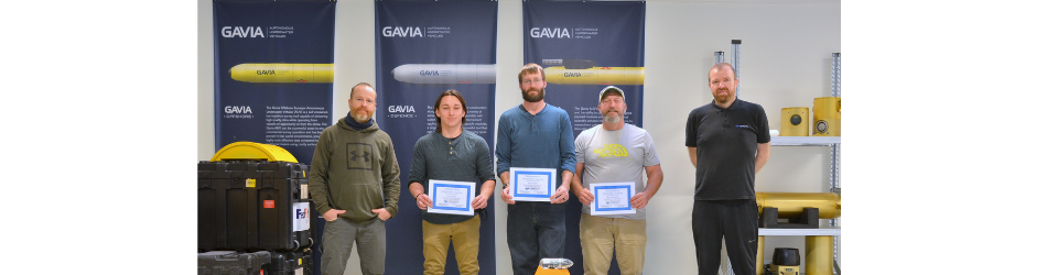
A global leader in the manufacture of Unmanned Maritime Systems, Teledyne Marine – Vehicles announces that Terradepth, a disruptor in maritime data collection and management space, has greatly expanded its survey operations capabilities by acquiring three Teledyne Marine Gavia autonomous underwater vehicles (AUVs) to support the rollout of its Ocean Data as a Service and Absolute Ocean data platform.
“We’re excited that Terradepth chose our AUV as the best solution to meet their goals,” stated Brian Maguire, Marine Chief Operating Officer and Vehicles Business Unit General Manager. “Terradepth’s application is a perfect fit with our purpose of enabling humanity to understand the marine environment like never before to explore, preserve, and protect the world.”
The Gavia AUVs are highly configurable and carry a depth rating of up to 1000 meters, making them ideal components to meet the growing demand for Terradepth’s survey services in shallow and medium depths. To help achieve these services, the three Gavia AUVs are each equipped with an Edgetech 2205 600/1600 kHz Module that retrieves both Side Scan Sonar and Bathymetric Sonar data, RDI DVL-aided IXBlue PHINS C3 Inertial Navigation Systems for accurate navigation, and field-replaceable battery modules from Teledyne Energy Systems for longer endurance. Future updates include Teledyne T20 Multi-beam Sonar and Sub-bottom profilers. The Gavia AUVs were also delivered with a Science Bay Module in anticipation of installing scientific sensors based on operational need. Terradepth’s expanding services have also received a boost with the introduction of Absolute Ocean, which combined, comprise Terradepth’s survey-as-a-service offering.
Absolute Ocean (AO), a cloud-backed, browser-based, geospatial data platform, enables storage, search, visualization and analysis of ocean data, whether collected by Terradepth or a third party. This unique capability allows users to leverage geospatial ocean data on a petabyte scale to view, search and query from any web browser.
“These moves bring Terradepth closer to its goal of creating a comprehensive and highly accurate virtual ocean model. Our vision is to allow humans to make better, faster decisions with respect to the underwater sector at large,” said Joe Wolfel, co-CEO at Terradepth. “This will help predict atmospheric weather patterns, build underwater energy and telecom infrastructures, and protect and ensure our coastal communities’ future.”
Subscribers benefit from AO’s functionality, which includes:
● Geospatial Search — Explore datasets from around the globe and filter by geographic region.
● Temporal Search — Search for and specify results by time frame.
● Object of Interest Search — This machine-learning-powered automatic target recognition allows users to search by text field for objects of interest within their search results. These can include pipelines, hazards, or other man-made debris.
● Persistent Data Storage — AO provides scalable, cost-effective data storage, ensuring accessibility and immutability to previously collected data, preventing resurvey of previously surveyed areas if up-to-date information is not desired or required.
“We’re excited to be able to offer a complete suite of ocean data management solutions,” said Judson Kauffman, co-CEO of Terradepth. “The Gavia AUVs, combined with Absolute Ocean, will reveal new insights that are as easily searchable as looking for something on Google.”
AO currently offers high-resolution side-scan sonar, multibeam bathymetry and overhead satellite imagery, with a future roadmap that includes satellite-derived bathymetric data, sub-bottom profiling data, and water column data such as current, temperature and other environmental factors.
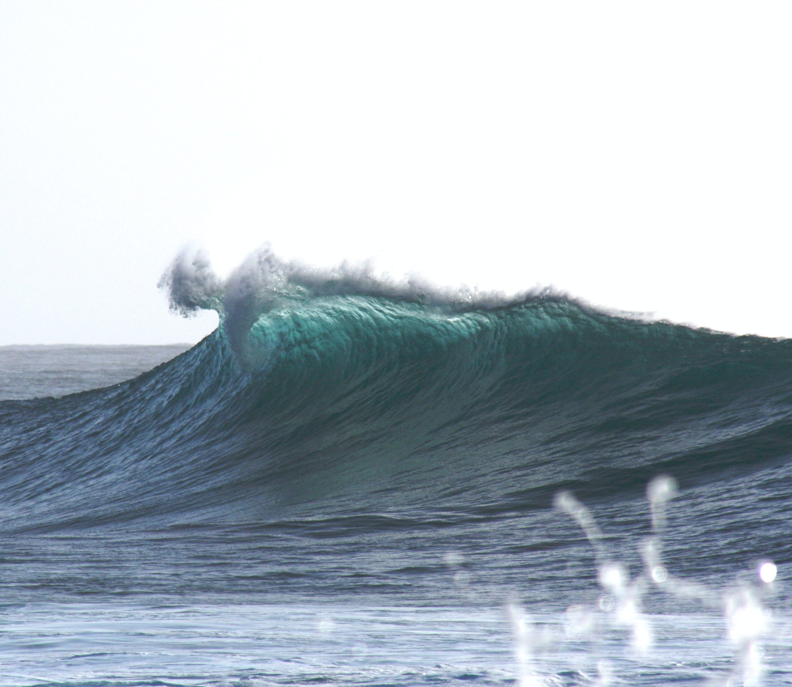
Van Oord deploys iXblue LBL subsea positioning solution for offshore wind farm piles installation
 Global marine contractor Van Oord recently deployed iXblue new LBL subsea positioning solution to conduct the installation of 190 offshore wind farm piles in the Bay of Saint-Brieuc (France). Already used on major Oil&Gas and Renewables projects, iXblue Canopus transponders, Ramses transceivers and Delph Subsea Positioning Software have been used by Van Oord to conduct metrology operations. Those aimed to ensure the laid-out piles had been positioned as per the requested specifications.
Instant pile positioning verification was made possible by installing the Canopus LBL transponders on top of a centering frame which was placed on top of each of the pile that made up the wind turbine foundations. (3 piles per turbine). The Canopus transponders then measured and logged the distance separating them by sending acoustic interrogations to each other. The logged data was then transferred to the Ramses LBL transceiver and sent back to Delph Subsea Positioning global supervision software that generated reports from all received baselines.
“Thanks to our global subsea positioning solution, Van Oord was able to retrieve highly accurate measurement data only 20 minutes after the Canopus transponders had been installed on the piles. This enabled the overall baseline measurement to be conducted in less than 3 hours for all four piles installed at the time,” explains Hans-Willem Deleeuw, Sales Manager at iXblue.
Delivering operational efficiency and flexibility, iXblue LBL subsea positioning solution indeed offers plug & play, easy to deploy and to operate systems. Versatile, they can be used on multiple offshore applications such as metrology or ROV/AUV positioning and are easy to integrate to existing pool of equipment thanks to their open protocols. When used in combination with iXblue Inertial Navigation Systems, innovative SLAM and Sparse LBL modes can be used, deploying a reduced number of transponders, and thus enhancing operational efficiency and cost-effectiveness.
“The intrinsic qualities of our LBL solutions, together with the comprehensive remote training of Van Oord personnel, as well as 24/7 support from the iXblue teams made this wind farm metrology operation a real success.” Hans-Willem continues. “We would like to thank Van Oord for once again trusting our technology and are now looking forward to our next deep water subsea positioning project with them providing cost-effective LBL and sparse LBL operations.”

Hydromea successfully trials its wireless ROV system at TotalEnergies offshore site in the North Sea
Hydromea successfully trialed EXRAY, its wireless underwater ROV system, within a full ballast water tank on one of TotalEnergies’ North Sea floating production, storage and offloading (FPSO) vessels during November 2021. EXRAY was deployed to collect visual inspection data, validating system performance including wireless navigation and wireless communication.The pilot was able to command and control the vehicle and receive real-time 1080p video feedback, using proprietary wireless optical communication technology that replaces a cabled connection. Without a tether attached, the risk of entanglement in complex confined spaces is greatly reduced.
This project is funded by the Net Zero Technology Centre based in Aberdeen, Scotland and is part of a larger development roadmap focused on enabling portable and affordable multi-robot inspections of the increasing number of submerged assets in the North Sea.
Stephen Ashley, Head of Offshore Energy 4.0 at the Net Zero Technology Centre said:
‘The development of remotely controlled operations empowered by robotics and autonomous systems is key to drive the net zero goals of the energy industry. Hydromea, a graduate of our TechX programme, has developed a game-changing technology that will play a pivotal role in accelerating our transition to an affordable net zero energy industry. This successful pilot trail has proven the EXRAY technology in a real environment and we look forward to supporting Hydromea through the final validation pilot later this year.’
Alexander Bahr, co-founder and COO of Hydromea, added:
“Thanks to Net Zero Technology Centre and TotalEnergies, we were able to test our system in the real environment of an offshore site. This is a valuable experience for our development team and it gave us plenty of data points to work with and prepare to our summer validation pilot of the beta system. We are currently looking for the industry partners to work with us in our next funded phase of the roadmap that shall kick-off at the end of 2022.”
Founded in 2014, Hydromea is a Swiss-based underwater robotics company helping its customers to have an unparalleled underwater data connectivity and efficient remote inspection access to submerged assets. The portable autonomous underwater drone platform with its array of unique technologies developed in-house, brings a paradigm shift in how submerged assets are inspected and monitored, enabling the sustainable growth of the ocean economy.
The EXRAY prototype ready for the dive at the TotalEnergies site.

First Uncrewed Vessel Survey in Irish Waters undertaken by XOCEAN
Company to recruit 100 new hires in next six months
In a first for Ireland, an Uncrewed Surface Vessel (USV) was launched by XOCEAN off the Co. Louth coast last week, to undertake an environmental survey of the seabed in collaboration with Dundalk Institute of Technology (DkIT). This is the first time an uncrewed vessel has operated in Irish waters and represents a major step forward in reducing the carbon footprint associated with offshore survey operations. XOCEAN’s carbon-neutral approach to delivering marine data has seen demand for its services grow steadily since it commenced operations in 2019, and with clients across the globe, and revenue tripling in 2021, the company is set to continue its impressive growth trajectory in 2022.
XOCEAN is pioneering uncrewed marine technology and to-date has delivered over 100 projects globally for some of the world's largest companies. In the last 12 months, the XOCEAN team has grown from 41 to 120 and plans to recruit 100 additional hires in the next 6 months. Ireland is fast-tracking the development of its offshore wind sector in line with commitments to increase offshore wind capacity to 3.5GW as part of the government’s ambitions to deliver 70% of electricity from renewable sources by 2030, as a result of the 2019 Climate Action Plan. This environmental research survey, utilising multi-beam echo-sounder sensors will be used to characterise the seabed in this area of the Irish Sea.
XOCEAN’s USVs offer significant benefits including safety with operators remaining onshore, efficiency with 24/7 operations and environmental with ultra-low emissions which together leads to significant economic savings for customers. The uncrewed vessel is around the size of an average car (4.5 metres) and half its weight (750kg) and emits just one thousandth of the carbon typically produced by traditional offshore survey vessels. Throughout the survey, a team of qualified mariners and surveyors monitored the USV 24/7 to ensure the safety of navigation and that the highest quality data was collected.
Having operated in 16 jurisdictions globally in North America, Europe and Asia, XOCEAN is delighted to have completed last week’s survey in Irish waters and is grateful to the Minister of State at the Department of Transport, Hildegarde Naughton T.D. and the Marine Survey Office for their engagement and support in enabling this highly innovative project to be delivered.
Commenting on the project, James Ives, CEO of XOCEAN said:
“Our USV platform has demonstrated itself to be a safe, reliable and low carbon solution for the collection of ocean data. We are delighted to be working in Irish waters and in collaboration with Dundalk Institute of Technology, on this important environmental project.”
 Hildegarde Naughton, T.D. and Minister of State at the Department of Transport, and former Chair of the Oireachtas Committee on Climate Action has been keen to highlight the Government’s responsibility to address the urgent issue of climate change, stated: “We are constantly looking for innovative ways to promote positive sustainable action on climate change and XOCEAN’s low-carbon approach to delivering marine data in the safest way possible is a very positive step forward. The vision and innovation demonstrated by Irish based XOCEAN creates opportunity for the development of sustainable projects to be conducted in a sustainable way, such as the preparation of sites and route planning for offshore wind energy projects. Transport has an important role to play in terms of tackling our emissions and the technology development of uncrewed marine vessels in a safe and carbon neutral manner is to be welcomed and embraced.”
Find out more about XOCEAN’s work and career opportunities at www.xocean.com

Fugro targets reduced carbon footprint in Canada with remote technologies
Fugro is building a remote operations centre (ROC) in the company’s St. John’s office, located in the province of Newfoundland and Labrador, Canada. The ultra-modern communications hub is scheduled for completion in Q4 2022 and will complement Fugro’s global network of ROCs, which make it possible to complete offshore operations onshore via remote and autonomous technologies. For Fugro’s clients in eastern Canada, this will mean safer, more efficient and more sustainable delivery of marine Geo-data and related services.
The St. John’s ROC is being funded in part by the Newfoundland and Labrador Offshore Oil and Gas Industry Recovery Assistance Fund, a programme of the provincial and federal governments. It was selected for funding based on the ROC’s local employment opportunities, environmental benefits and support to existing oil and gas installations. In addition to building the onshore communications hub, Fugro will upgrade their equipment on selected offshore client assets to facilitate remote services. Fugro will also offer their remote and autonomous services to non-oil and gas clients both locally and abroad, while expanding a diverse and inclusive local employment pool.
Pat Byrne, Fugro’s Marine Asset Integrity Manager in Canada stated:
“We are thrilled to have the government’s support on building an ROC in our St. John’s office and we are proud to help lead the region’s digital transformation, accelerating and enhancing the application of remote operations in the region to reduce the carbon footprint of energy development. Fugro has been moving in this direction for some time and we have seen tangible and significant benefits from our advances in digital technology worldwide.”
Dewberry first to purchase advanced CZMIL SuperNova lidar bathymeter in North America
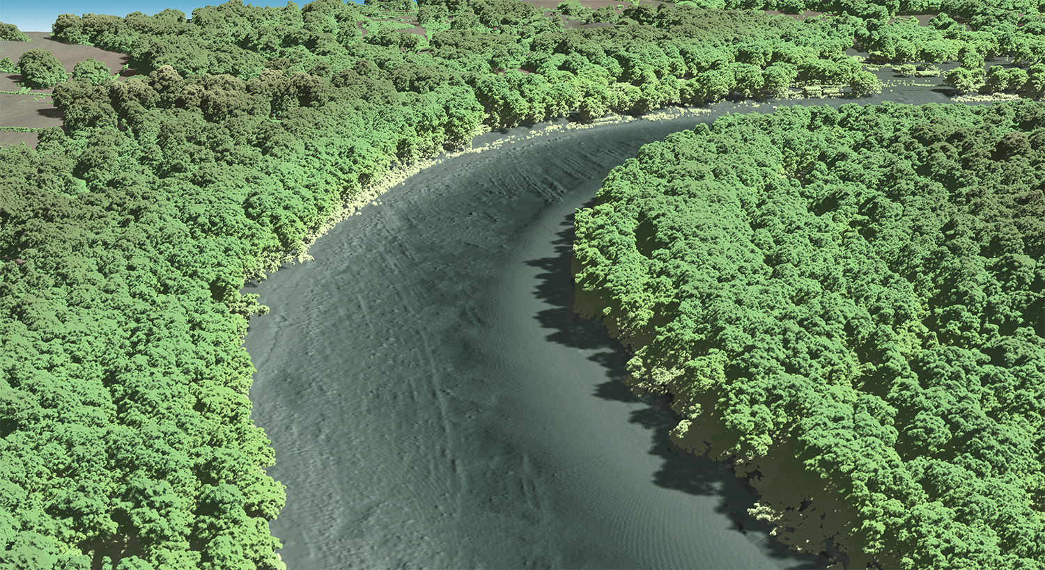
Teledyne Geospatial announced the sale of its next generation bathymetric lidar CZMIL SuperNova to leading professional services firm Dewberry. Dewberry is the first private North American company to purchase the CZMIL SuperNova, adding this unique capability in support of state and federal coastal zone mapping programs, surveying of wetlands, lacustrine and riverine systems, submerged habitat detection and offshore mapping for renewable energy governance.
The CZMIL SuperNova’s ability to deliver Quality Level 1 (QL1) data from altitudes greater than 1,200 feet and its Secchi depth penetration range (down to 70 meters in optimal conditions) will allow Dewberry to deliver the quality data required for their projects. Leveraging advanced artificial intelligence and machine learning (AI/ML) techniques for automated land/water discrimination and noise classification, the CZMIL SuperNova bathymetric solution also sets a new standard in processing workflow efficiency through automation in the CARIS software suite without compromising quality.
Dewberry Senior Vice President Amar Nayegandhi states, “In 2022 Dewberry will provide clients with unmatched capabilities in coastal, wetland and inland riverine mapping. This investment in the CZMIL SuperNova and collaboration with Teledyne Geospatial solidifies Dewberry’s commitment to client excellence through the acquisition and delivery of the highest quality topo-bathy capability available in the market. The impressive Secchi depth and single-source workflow features will enhance the speed and accuracy of deliverables to our clients.”
Teledyne Geospatial North America Senior Sales Manager Brenda Burroughs comments, “We are thrilled that Dewberry will be the first privately owned North American company to take possession of the CZMIL SuperNova and are excited to continue our collaboration as they add this exceptional capability to their portfolio. The CZMIL SuperNova will empower Dewberry with a geospatial solution for acquiring, processing, and delivering data projects within a single workflow underpinned by a CARIS software toolkit that will automate data classification and expedite the delivery of projects with the net benefit going to their customers.”
Teledyne Geospatial unifies the hardware and software expertise of both Teledyne CARIS and Teledyne Optech. The new group provides customers with innovative integrated solutions. Offerings include turnkey systems, lidar and sonar integrated workflows and a range of systems and solutions that support holistic, precision data collection.
Dewberry is a leading, market-facing firm with a proven history of providing professional services to a wide variety of public- and private-sector clients. Recognized for combining unsurpassed commitment to client service with deep subject matter expertise, Dewberry is dedicated to solving clients’ most complex challenges and transforming their communities. Established in 1956, Dewberry is headquartered in Fairfax, Virginia, with more than 50 locations and 2,000+ professionals nationwide. To learn more, visit www.dewberry.com.
TDI-Brooks completes geotechnical programs in the Black Sea
TDI-Brooks completed two (2) geotechnical support projects for DenAr Ocean Engineering S.A. for the TPAO Sakarya Gas Field Pipeline Route Investigation and Site Survey Project. The project consisted of two (2) cruises.
During the first cruise in April 2021, TDI-Brooks acquired approximately thirty (30) gravity CPTs (gCPTs) with our memory standard 15 cm2 CPT cones. TDI-Brooks’ CPT cones were fitted onto Denar’s piston core (PC) rigs. On box cores, TDI-Brooks provided our cyclic T-Bar’s using Den-Ar’s provided box cores. This project was conducted on the “DENAR 2” vessel over a period of 71 days in the Turkish portion of the Black Sea.
The purpose of the Gravity CPT Stinger (gCPT) tool is to transport a piezocone penetrometer down to the seabed or lakebed to gather dynamic PCPT cone data from the mud line to typically 6-10 m or even 20+ m BML. In addition to its 800 kg driving head with lifting bale and coupling, the rig comprises a self-contained PCPT cone penetrometer that measures tip resistance, sleeve friction and pore pressure using standard ASTM cone protocols. The gCPT system is deployed using the same winch, A-frame, and process as for piston coring. When just above mudline, the tool is triggered like a piston corer to ballistically insert itself into the soil. Once the cone insertion into the soil is complete (less than 3 sec after trigger), the system is immediately retracted from the seabed and retrieved to the deck. Cone data are downloaded from the probe for evaluation and analysis. The tool is readied for the next deployment, typically in less than 5 minutes, making numerous measurements per day feasible, depending only on water depth and winch speed. The maximum water depth for the gCPT is 4,000m.
The TDI-Brooks Auto T-Bar instrument measures the progressive resistance of a soil column to a cylindrical rod (shaped as an upside-down T) as it is pushed down the soil column at a constant rate. Operation consists of mounting the instrument onto a box corer containing an undisturbed seabed soil sample, connecting the instrument to a source of compressed air, and starting the automatic advance of the T-Bar into the soil sample. The resistance of the soil is automatically logged during the downward advance until the bottom of the soil sample is reached by the T-bar. The instrument then reverses T-bar movement and logs the soil resistance generated during the upward, retracing return of the T-bar back up to any desired soil depth or to the surface. This sequence of a downward stroke followed by upward re-trace through the failed soil can be immediately repeated as many times as desired. Sets of 10 such cyclic T-bar tests are typical in box cores.
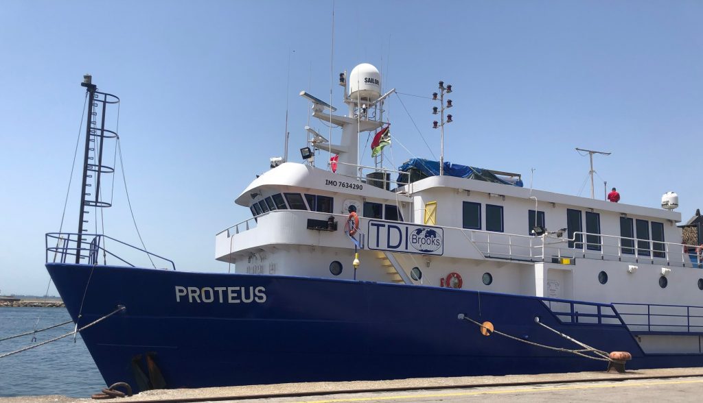
For the second cruise on the project in July 2021, TDI-Brooks mobilized our research vessel, the R/V PROTEUS, to the Black Sea for ‘heavy’ geotechnical coring/CPT acquisition. This geotechnical program acquired several dozen 20 meter Jumbo Piston Cores (JPCs), 40 meter CPT-Stingers and up to 40-m SB Shelby-tube Stinger-Samplers. The PROTEUS is outfitted with TDI-Brooks’ complete geotechnical tool kit including a suite of innovative geotechnical tools for soil sampling and CPT measurement. The PROTEUS also has a Kongsberg EM-710 (1x1) hull-mounted multibeam (MBES) for surveys to ~2,500m water depth for performing surface geochemical “seep-hunting” (SGE) and seabed heat flow surveys (HF).
More details on our Seabed Geotechnical Services HERE.
Awel y Môr: seabed mobility and scour assessment underway for new offshore wind farm
RWE Renewables has appointed ABPmer to support the design of the Awel y Môr Offshore Wind Farm in the Irish Sea.
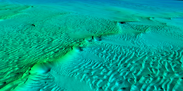
ABPmer is assessing the sediment mobility and scour potential at the wind farm site, located in a dynamic area of seabed off the north Wales coast. The work will be used to help support export cable route selection, as well as inform the ongoing wind turbine foundation and array/export cable design process.
To map the behavioural characteristics of the seabed across the wind farm site and export cable corridor, ABPmer will analyse oceanographic data from its SEASTATES metocean database, recent and historic seabed surveys, and geophysical data specifically collected for the project.
High resolution hydrodynamic and sediment transport modelling are also being used to map the detail of long-term regional scale sediment transport pathways.
Heidi Roberts, ABPmer Project Director, said, “Building on our local knowledge from Awel y Môr and adjacent windfarms along with OWF expertise around the UK, our specialists are completing detailed statistical analysis, modelling and interpretation of oceanographic and geophysical data.
Our seabed mobility risk mapping tools are helping RWE understand present and future bedform migration, providing vital information in support of the cable route selection and design.”
GIS analysis of coastal data will also be undertaken to consider the potential for coastal erosion and vertical change in beach levels at the landfall over the project lifetime, supporting the landfall selection and design process.
The Awel y Môr detailed design will continue through 2022, with the wind farm targeting 2030 to be fully operational.
A recognised Development Service Provider offering a wide range of services that support clients throughout renewable project lifecycles, ABPmer has provided input to most of the UK’s offshore wind developments, including technical input to engineering design that satisfies both consenting requirements and international standards.

Deputy Head of Hydrography, EGS
An exciting opportunity exists at EGS to join our Survey Department as Deputy Head of Hydrography. You must be an experienced and dedicated professional prepared to be involved in both office and site work, you will have knowledge of data acquisition, processing and reporting. Applicants must have a relevant first or second degree/diploma in Hydrography / Surveying and at least three, preferably five years’ relevant practical experience. Working knowledge of QINSy, SIS, POSMv for acquisition and POSPac, Caris and Global Mapper is highly desirable.
You will be based at our office in Bordon, Hampshire and will work full-time on projects in the UK and worldwide. You will be involved in survey planning, mobilisation/demobilisation, acquisition, processing and reporting. Possessing good interpersonal and communication skills along with experience of motivating and managing a team of surveyors. You should possess good analytical skills and the ability to identify and solve problems.
EGS offers a competitive remuneration package based upon experience together with a professional, friendly and COVID compliant and hybrid working environment.
You will be part of a hard-working and dedicated team involved in complex marine survey projects in the Renewables, Oil and Gas, Utilities and Cable Route sectors.
You must live within or be willing to relocate to a commutable distance of the EGS office in Bordon, Hampshire.
To apply for this position please send your CV to [email protected]