
Proposals Manager vacancy at SAMS Enterprise
Contract: Full Time, Permanent Position
Salary range: £40,322 to £45,361 per annum - starting salary will depend on experience.
Office Location – Malin House, European Marine Science Park, Oban.
The Ideal Candidate:
As a highly motivated business professional, with excellent communication and organisational skills, you will enjoy the challenge of leading on the preparation and submission of commercial tenders and business proposals to facilitate commercial access to our cutting-edge marine science consultancy. You will be experienced in the collation of data and identification of resources to create impactful, winning tenders and proposals. You will be flexible and motivated to understand and deliver to customer requirements. You will have an impeccable eye for detail and the ability to work to tight deadlines.
The Role:
You will lead on the development, preparation, pricing and submission of high-quality tenders/bids to secure profitable contracts for SAMS Enterprise. Working with business development, project delivery and research colleagues, you will produce well-crafted responses which fully satisfy client requirements and maintain an enviable conversion rate from enquiry to delivery. You will support and manage internal and external stakeholders involved in each deliverable, making this a varied and challenging opportunity.
With responsibility for the Proposals Administrator, you will coordinate all proposals activity and ensure maintenance of internal governance procedures relating to bid submission and client management.
You will be an integral part of the management team within SAMS Enterprise, supporting development of budgets, business plans and commercial strategy. You will also engage in client facing activity, including attendance at relevant conferences and exhibitions.
You will be a highly skilled, scientifically/technically minded wordsmith with a track record of winning high value, high impact, six figure contracts from public sector, research and innovation and industry clients. You will be pragmatic, practical and diplomatic in developing winning solutions with colleagues and collaborators.
This role sits within SAMS Enterprise, the commercial subsidiary of SAMS.
So, what do we offer in return?
Looking for a change in lifestyle or location? We are based on the beautiful west coast of Scotland – within Argyll & Bute. In addition to your salary, we offer flexible working, a generous remuneration package including pension, holiday allowance, structured career development path, free on-site parking as well as occupational health & wellbeing support. In addition, our employee benefits package includes purchase of additional holidays, technology & smartphones, payroll giving, discounted shopping vouchers and a cycle to work scheme.
Interested? We would love to hear from you. If you have queries on the job and would like to talk these through before applying, please email these through, in the first instance, to Mike Spain at [email protected]
Applicants must apply by CV and cover letter – your letter should outline your experience to date as well as what you can bring to the role.
For further information and to apply for this position online, go to: https://sams.myciphr247.com/jobsearch.aspx, or email [email protected] (Job Ref. SE6/21.MS)
Closing date for all applications is 4th February 2022
Interviews will be held in February

Partrac are Hiring Multiple Roles – Senior Metocean Engineer, Metocean Engineers, Principle Oceanographer ,Oceanographers, Project Managers & Data Analyst
If you are an experienced oceanographer, metocean engineer, marine project manager metocean consultant or data analyst, with a passion for the marine environment and renewable energy, we want to hear from you. We are growing and need more specialists to join our team, in order to help our clients, plan and execute successful measurements projects offshore.
You will find yourself in a culture that champions continual improvement, openness, and teamwork. If you are on the lookout for new, better ways to do things and want to be supported by a talented team of peers, you will fit right in here.
Current vacancies are:
- Project Manager
- Principal Oceanographer
- Senior Metocean Engineer / Party Chief
- Metocean Engineer / Oceanographic Technician
- Data & Reporting Analysts
- Metocean Consultants
What you’ll get:
Working at Partrac means you are trusted to use your initiative. We will give you the freedom to follow your ideas and to make an impact.
Our company is growing quickly, so there are plenty of opportunities for progression. As we are a market-leading team and well respected in our industry, working with us will be an excellent career move.Some of the benefits our team love include: –
- Working in a market leading team with a high level of industry recognition
- Interesting and varied projects that make a difference.
- A resilient, dynamic working environment.
- A friendly, supportive team.
- Generous holiday allowances.
- Flexible working options.
- Competitive salary and benefits.
Balance is important at Partrac. The metocean department is based in Devon, in the heart of the southwest, within striking distance of Dartmoor and amazing surf beaches a great place to live and work.
To apply:
Please visit https://www.partrac.com/careers for further information.
Or send in your CV and covering letter into [email protected]
– Closing Date 17th January 2022
Greensea Hires Vice President of Business Development - Defense
Santana brings more than 20 years of military experience to new role
Greensea, creator of OPENSEA®, the universal open architecture software platform for the marine industry, announces the hire of Paco Santana as Vice President of Business Development - Defense. Paco will immediately begin connecting with and developing relationships with current and future military partners.
“Paco brings a breadth of experience to Greensea having served in the US Navy, as well as having worked with some of the best known companies in the marine industry”, says Ben Kinnaman, Greensea CEO. “Who better to support our military customers than someone who truly understands the challenges and risks that they face? We are excited to have someone who is well regarded within this industry to lead our efforts in this area. I have known Paco for years and am truly honored to have him join the team.”
Paco joins Greensea after serving as a Commander in the US Navy for more than twenty-two years. He previously held Business Development positions at VideoRay, iRobot, and Riptide.
“I joined Greensea because of their commitment to the EOD and SOF communities'', says Paco Santana. “I want to be able to serve and support the military communities that are an integral part of who I am as a person. I am also excited to help Greensea meet all their future objectives.”
Greensea provides advanced open architecture software solutions, program support, and research and development for EOD and SOF Technologies. For more information, visit Greensea.com.

Fleetwide Extension - Miros Extends Services to Prysmian Advanced Cable Lay Vessel
Miros AS today announced it has signed an agreement with Prysmian Group, a world leader in the energy and telecom cable systems industry, for the installation of their IoT dry-sensor WaveSystem including Miros Cloud Services, delivering real-time wave and current data onboard the MV Leonardo Da Vinci. Miros AS is excited to extend our relationship with Prysmian fleetwide, providing real-time ocean insights essential for operational requirements.
“Miros is delighted to build upon our existing relationship with Prysmian Group, bringing the MV Leonard Da Vinci into line with systems installed on both the MV Normand Pacific and MV Cable Enterprise,” says Andrew Wallace, Vice President for Offshore Solutions at Miros AS. “A key area in our discussions with Prysmian was the ease and availability of real-time data accessible through our cloud-based Graphical User Interface (GUI) Miros.app. We believe the ability for Prysmian to access and share real-time wave and current data across departments is an important aspect for both onshore and vessel-based personnel and key to their digital journey.”
“We are very pleased with Miros WaveSystem providing us with wave, current and speed through water data with high accuracy operating independently of offshore weather conditions. The automatically calibrating cloud-enabled technology allows us to work safe, precise and highly effective fleetwide and at all times” says Hakan Ozmen, EVP Projects Business & CEO Prysmian Powerlink.
Miros WaveSystem: The Miros WaveSystem is comprised of the Miros Wavex, a virtual sensor designed for wave and current measurements using data from standard marine X-band radars, and the motion-compensated Miros RangeFinder, a high-frequency vertical microwave radar providing sea level and draught measurements. Miros’ IoT sensors are stand-alone devices with embedded processing and a browser-based user interface, meaning no integration or external processing is required. The devices can be complemented with various value-adding cloud services from Miros, such as weather sensors integration, web displays, data download, data push and device management services.
For further information contact: Andrew Wallace, VP Offshore Solutions, Miros AS
About Miros:
Miros is a technology company that specialises in measuring the ocean surface. Miros provides IoT dry-mounted sensors and systems for environmental monitoring to the global offshore and maritime industry. The portfolio of dry sensors delivers accurate, real-time data for weather sensitive operations offshore, as well as offering input to asset integrity systems and coastal monitoring. Miros is a world leader and trusted provider of reliable ocean surface measurements to some of the largest players in the global offshore and maritime industry for more than 35 years. https://www.miros-group.com
About Prysmian Group:
Prysmian Group is a world leader in the energy and telecom cable systems sector with decades of experience. Each year, the Group manufactures thousands of miles of underground and submarine cables and systems for power transmission and distribution offering the widest range of services and know-how in the business. Prysmian is constantly innovating to anticipate the needs of this fast-expanding market. The Group is especially active in the field of new installation solutions across the globe and its knowledge of submarine cable laying is second to none. With four of the most specialized cable-laying vessels in operation. https://na.prysmiangroup.com/

The Solent MEZ, in collaboration with Maritime UK Solent and Connected Places Catapult launched the Solent Maritime Innovation Gateway during LISW earlier this year.
The Solent Maritime Innovation Gateway will address the core challenge of coherence across the maritime ecosystem, by establishing a “One Stop Shop” for customers, businesses, researchers and innovators, easily accessed by international and national investors. It will utilise existing innovation hubs and facilities, supporting access to opportunities and potential future customers by creating a flourishing environment of exciting ideas, strong relationships and innovative technology.
You are therefore invited to the online design workshop on Thursday 20 January, 1400-1600 (please note, numbers are limited, therefore please complete the application questions upon registering to help shape the workshop). Full details can be found here:
Attendees will map the current maritime innovation landscape, contribute to the vision and identify the market opportunity for the Solent region.
Please feel free to contact us if you would like to learn more.
Hexagon’s R-evolution expands its sustainability agenda to help protect coastal blue carbon ecosystems
Hexagon AB, a global leader in digital reality solutions, today announced R-evolution’s efforts to map the threatened seagrass meadows of the Caribbean islands, beginning with the coastal waters of the Bahamas. In collaboration with Beneath The Waves – a leading, global, non-profit organisation dedicated to protecting marine environments – R-evolution is leveraging Hexagon’s airborne bathymetric LiDAR technologies to detect, map and capture critical details about this vital habitat, including its extent and composition.
Blue carbon ecosystems refer to coastal and marine vegetated habitats, such as seagrass meadows, salt marshes, and mangrove forests, that sequester and store carbon from the atmosphere and ocean. These powerful carbon sinks are rapidly disappearing in many parts of the world. Seagrass meadows, the most common among them, are crucial to solving environmental challenges yet remain among the least recognised and least protected ecological habitats.
As part of a long-term shark monitoring project to study and protect the oceans, Beneath The Waves discovered that tiger sharks spend a large portion of their life patrolling and foraging dense seagrass meadows. A combination of sensor tagged sharks, satellite data, marine vessel surveys and scuba divers drove the ongoing discovery and mapping of the extensive seagrass meadows of the Caribbean. But to protect and restore these blue carbon sinks, the findings must be validated with high positional accuracy and datasets that can provide efficient, year-on-year change detection and monitoring.
R-evolution is helping Beneath The Waves validate their findings by deploying survey aircraft geared with one of Hexagon’s airborne bathymetric LiDAR solutions, the Leica Chiroptera 4X. The airborne bathymetry solution enables the cost-effective, rapid survey of large areas—accurately mapping thousands of square kilometres of seabed habitats at up to 30 metres water depth in just a few days. The high-resolution point clouds and aerial imagery will allow Beneath The
“We have a planetary need to protect and restore our oceans—our biggest life support system harboring more biodiversity than any ecosystem on land,” says Hexagon President and CEO Ola Rollén. “The protection and restoration of seagrass meadows can not only improve ocean health and productivity — from purifying water to protecting food chains — but also aid the natural sequestration of massive amounts of carbon, providing major potential for offsetting pollution and reaching net-neutral carbon goals.”
While Hexagon and R-evolution focus on reducing the world’s carbon footprint, both companies continue to bring innovation, cutting-edge technology and corporate leadership to climate change mitigation strategies. By combining the marine expertise of Beneath The Waves with the technological expertise of Hexagon, the collaborative project expects to yield groundbreaking results for blue carbon conservation.
“Hexagon has been a major player in the airborne bathymetric LiDAR industry for many years,” continued Rollén. “R-evolution’s collaboration with Beneath The Waves is an excellent opportunity to deliver on the commitment to helping the world achieve its environmental goals. We are honoured to be a technology partner in this planet-saving research project, which aims to support, preserve and unlock the power of nature to build climate resilience.”
Launched in mid-February 2021, R-evolution is Hexagon’s business venture focused on reinventing how industry addresses complex environmental challenges, profitably, using Hexagon’s digital reality solutions. Learn more about R-evolution’s projects that accelerate the world’s transition to a sustainable economy.

Bespoke marine engineering experts Ocean Scientific International Ltd (OSIL) are excited to report high levels of international demand for their unique USV profiling winches.
The compact and programmable winches are designed to equip USV systems with the ability to safely deploy and recover instrumentation at specified depths during an operation, enabling surveys to be carried out in places that are too high risk or inaccessible for crewed vessels.
The winches are easily integrated into most USV control systems, with status notifications for docking, zero position and payout readings & can accommodate a wide variety of ropes/cables and slipring combinations, with 50kg line pull at the first layer and a 500m drum capacity (based on 3mm dyneema).
The automated winches have recently been successfully proven in the field in Arctic conditions, in a joint project between Maritime Robotics and UiT – The Arctic University of Norway.
For further information or sales enquiries please contact: [email protected] or call +44 (0) 2392 488 240.
Air Quality Monitoring in Ports and Harbours
Air Quality Monitoring in Ports and Harbours Ports and harbours have grown up close to heavily populated areas and air pollution is or should be, of concern to both city and port authorities. As the commercial success of a port increases the prosperity of the surrounding community, pollution levels tend to increase. Multiple emission sources including those from ships, port handling equipment (diesel engines), the process of unloading break-bulk and those generated within the city itself create a complex air quality landscape with many moving parts. How do we accurately assess it?
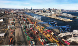
Traditionally, expensive reference equipment has been used by government sources to monitor background air quality. These remain the gold standard at a legislative level and it is understandable that port authorities would hesitate to deploy analytical products in any measurement campaign. Not only are they very expensive, but they are also large and do not lend themselves to being easily repositioned to suit different measurement needs. The other option has been to use passive diffusion tubes, a simple indicative technique. Whilst very low-cost and can measure longer-term average gas concentrations in a specific location, they cannot track changes in air quality over minutes, hours or days.
To assist port authorities in understanding their impact on air quality and to enable actions that the port can take to address emissions under their control, self-regulation is vital. Yet, the financial burden of installing analytical equipment suitable for comprehensive monitoring has been prohibitive. Over the course of the last three years, South Coast Science has worked to develop a portable product capable of data quality that is comparable with the reference-level monitor, yet at only one-tenth of the cost. Robust measurement of pollutants such as SO2, NO2, particulates, VOCs and others can now be
established with ease from products offering high accuracy and repeatability. All pollutant and device data is cloud-mediated and can be viewed online via the cloud dashboard.
It is clear that this new technology in general remains less well established than the traditional reference instruments. South Coast
Science has responded to this with a data correction algorithm and a policy of data transparency, which allows users and external specialists to interrogate and validate the data provided by the system. To this end, South Coast Science has developed an open-source platform that allows customers to do their own checks. The collaboration with global environmental consultancy Ricardo PLC is described in a short video here. Praxis monitor (white box) collocated with reference device (red)
The task of establishing baselines early on should be one of the aims of any measurement campaign so that subsequent pollution mitigation strategies can be measured and effectiveness established. For
this purpose where priorities are yet to be decided, consulting services might be used to assist in focussing on the quickest wins with the most economical solutions. South Coast Science has worked with independent air quality consultants with many years of experience in various market sectors and would be happy to pass on details.
Delivery of EGIM, EMSO Generic Instrument Module
The EMSO: European Multidisciplinary Seafloor and water column Observatory is the European network of seabed and water column observatories formed in ERIC (European Research Infrastructure Consortium) since September 2016. It has now 9 members: Italy, France, Ireland, Spain, Romania, Greece, United Kingdom, Portugal and Norway, represented by recognized research institutes.
The main objective of EMSO is to conduct studies of the impact of global warming on the oceans surrounding Europe. This objective includes the study of deepwater ecosystems in a perspective of fundamental research but also in term of sustainable management, with particular interest in anthropogenic and climatic factors, as well as generating continuous scientific data on marine environmental processes related to the interaction between the geosphere, the biosphere and the hydrosphere.
Finally, the study of tectonic, volcanic, hydrothermal and gravity processes as well as the monitoring of associated natural risks (earthquakes, tsunamis, instability of slopes) supplement the research for coastal areas with high population density.
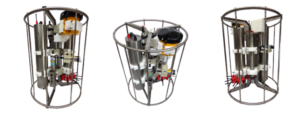
In this context, RTsys has developed the EGIM: “EMSO Generic Instrument Module” in partnership with IFREMER with the main focus of standardizing the measurements obtained at different geographical locations using the same equipment, the same sensor references, the same methods of qualification and calibration, the same data formats and the same maintenance procedures.
From the surface to the deep sea, this high-tech platform would embed the most advanced technologies of sensors measuring physical and biogeochemical parameters continuously and on long term process.
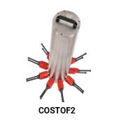
The heart of the EGIM system is called COSTOF2. Resulting from a joint development between RTsys and IFREMER, COSTOF2 is a deepwater datalogger (up to 6000m depth) that provides a unique operating and recording module (sequencing, synchronization, storage, data transmission) for a wide range of sensors from different types, models and brands over a long period in total autonomy. Particular attention has been paid to its modularity and low consumption, giving the capability to connect any kind of sensors, from the simplest to the most complex.
EGIM has been designed to consistently and continuously measure environmental parameters in order to provide data on marine changes in Europe, and will soon be deployed by IPMA (Portuguese Institute for the Sea and the Atmosphere) offshore the southwest coast of Portugal, at 4830m depth.
Such deep water observatories being installed and left at sea for very long duration, EGIM must therefore be resistant to external attacks, in particular electrolytic corrosion hence the use of the plastic/titanium pair has been targeted to answer to these operational constraints.
EGIM now provides a selection of referenced sensors fully synchronized in the COSTOF2 which itself supplies the necessary power required by each sensor, when previously for any similar research mission, each user of underwater observatories had to use its physicochemical sensors chosen or constrained by the use of several different data loggers to be integrated into the same mechanical structure to be deployed. It was then necessary to extract the data recovered from each sensor via proprietary softwares. With the COSTOF2 it is now possible to recover all the data fully synchronized by acoustic modem from the surface or by WIFI. COSTOF2 can be operated on mooring lines, seabed stations (wired or not) and surface buoys too.
The data can be downloaded on regular basis and made available to all project stakeholders.
Characteristics and strengths of EGIM:
- 7 generic parameters
- The possibility of strictly intercomparing the data of any EGIM with another
- Ultra low consumption and high bandwidth capacity
- Wide adjustable power supply range without opening the enclosure
- Power and data distribution up to 12 sensors (5 to 24 Vdc, serial or Ethernet communication)
- Time-stamping of data with a clock common to every sensor with a drift of less than 1min / year with TCXO
or 1.5ms / year with atomic clock - Antifouling protection with integrated active chlorination antifouling capability for optical sensors
- Modular to integrate a new instruments
- Maximum operating depth: up to 6000m
In addition to the data logger function, EGIM has the possibility of triggering actions on events: focused power supply and record’s triggering of certain sensors in parallel to a targeted value detection from another sensor.
The COSTOF2 is used on every IFREMER instrumented, non-wired and long-term test sites. In particular on EMSO Azores with two seabed stations (including one EGIM) connected by acoustic modem to a surface buoy. It is also equipped with a COSTOF2 surface version which re-transmits its data to earth via satellite. http://emso.eu/observatories-node/azores-islands/
COSTOF2 also equips deep sea stations such as MARHA deployed last August, the coastal measurement buoys integrated into the COAST-HF network and equipped with the COSTOF2 surface version, and to finish into every future deep, shallow and coastal observatories IFREMER plans to deploy in the coming years in the areas of Mayotte and New Caledonia, for environmental monitoring applications (MRE, aquaculture farms, ports, exploitation of mining resources...)
TDI-Brooks completes geotechnical program in Gulf of Mexico
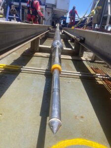
TDI-Brooks recently completed a Geotechnical Site Investigation for Beacon Exploration & Production LLC (“BOE”) in the deepwater Gulf of Mexico. The project consisted of ‘heavy’ geotechnical coring/
cone penetration testing (“CPT”) with TDI-Brooks’ research vessel, the R/V GYRE. The project included the acquisition of 20-m Jumbo Piston coring, 40 meter CPT-Stinger samples and 40 meter
Shelby-tube Stinger samples.
Other piston, box core and gravity CPT (gCPT) samples were acquired associated with oil and gas export pipelines. The Shenandoah field development project is located in the Walker Ridge (WR) area in water depths ranging from 5,800 to 6,300 feet. The Shenandoah field will be developed as a subsea tieback from a drill center in WR-51 to a new build Floating Production System (“FPS”) located in WR-52.
TDI-Brooks worked closely with BOE and BSEE in expediting the permit. Following completion of the geotechnical coring campaign, TDI-Brooks shipped the soil samples back to its certified soil testing laboratory in Co