

Ocean Infinity to deliver a zero-emissions marine propulsion system
UK Government backed partnership programme for a ground-breaking
Ammonia based fuel cell system for Armada fleet
Ocean Infinity, the marine robotics company is pleased to announce it is a winner of The Clean Maritime Demonstration Competition, enabling the Company and its partners to build a Marine Propulsion Test facility, with an integrated Ammonia Marine Propulsion System (AMPS). The test facility will demonstrate clean-fuelled technology eventually capable of powering Ocean Infinity’s Armada fleet, using an innovative ammonia based fuel cell system.
The Clean Maritime Demonstration Competition is funded by the Department for Transport, with Innovate UK acting as delivery partner. With Ocean Infinity acting as lead partner, the company is combining forces with UK-leading experts in clean fuel cell technology; maritime logistics; deployment and operation of remote and autonomous technology; and the development of operational regulations. The project team consists of an industry leading operator, Oxford Green Innotech, the University of Oxford and the University of Southampton’s Marine and Maritime Institute.
Currently, most vessels use Green House Gas intensive internal combustion power systems. Directly targeting key elements of the UK Government’s 2050 Clean Maritime Plan, Ocean Infinity and its partners are introducing innovative new technologies and techniques for clean vessel propulsion, expecting to make a meaningful contributing towards the UK’s net-zero greenhouse gas commitment.
This project, due to deliver a zero-emissions marine propulsion system, is crucial for developing a robust understanding and thus optimisation of an AMPS, suitable for integration into Ocean Infinity’s Armada fleet and beyond.
Dan Hook, Ocean Infinity’s Chief Technology Officer, said:
“Winning The Clean Maritime Demonstration Competition is a significant step forward in the delivery of a zero emissions marine propulsion system. Working with the UK’s leading experts, we are driving forward a ground-breaking ammonia based fuel cell system, which will not only make the Armada fleet the cleanest in the world, but also has the potential to revolutionise marine propulsion systems.
I would like to extend our thanks to the Department for Transport, and Innovate UK, for instigating the competition and for their financial support of this important programme.”

Blue Ocean Marine Services validate AUV as an effective tool for PFW discharge monitoring
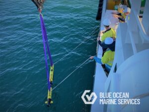
Blue Ocean Marine Services were recently contracted to conduct Produced Formation Water (PFW) discharge surveys in Western Australia using one of their L3HARRIS Iver-3 Autonomous Underwater Vehicles (AUV). The AUV was used to support the field monitoring team by providing additional high-resolution 3D water quality information in the discharge and mixing zones. The Iver-3 AUV, a low-logistics vehicle particularly suited to water quality surveys of this nature, was equipped with a Xylem YSI EXO1 Multiparameter Sonde, which is fitted with EXO conductivity & temperature (CT), turbidity, fluorescent dissolved organic matter (FDOM) and dissolved oxygen (DO) sensors.
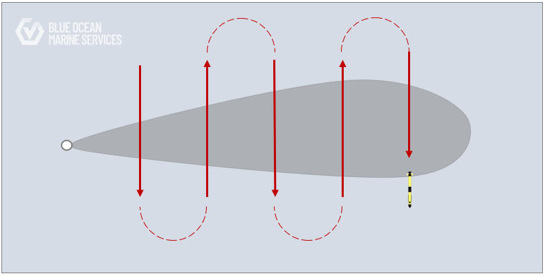
The AUV survey missions were planned to record data along equidistant transects perpendicular to the direction of the prevailing current and expected plume path. Surveys were completed over three days at two offshore facilities, and no detectable plume was recorded in the data, confirming the PFW discharges were released within accepted regulatory limits.
The AUV survey was safely and successfully conducted, and the AUV demonstrated:
– Low logistical effort in mobilisation and demobilisation
– Safe deployment and recovery from vessel
– Flexibility of the system to allow simultaneous operations to occur
– Adaptability and speed of mission planning
– Speed of data availability
For further information please get in touch here: [email protected] or visit www.blue-ocean.com.au
Act now to protect coastal communities from rising sea levels
13 October 2021
Ahead of COP 26, the Institute of Marine Engineering, Science & Technology (IMarEST), is calling for leaders around the world to take action to mitigate the impact on coastal communities and infrastructure of rising sea levels. This includes a recommendation to standardise the way oceans are measured globally to provide the data needed for greater understanding and sustainable management.
The advice comes as the Institute prepares to host its fourth biennial Oceans of Knowledge conference on 26-27 October, the week prior to COP 26. The conference will focus on three themes:
- The sustainable use of the ocean and its resources
- The role of the ocean in natural and engineered climate mitigation
- Rising sea levels and coastal vulnerability
Ralph Rayner, Co-Chair, IMarEST Operational Oceanography Specialist Interest Group which is organising the conference, explains: “This is an opportunity to hear from leading climate change specialists and to gain an understanding of how mitigating and adapting to climate change will impact the use of the ocean and ocean resources. The day dedicated to rising sea levels will then explore impacts where the ocean meets the land, seeking to better predict and respond to the challenges of protecting coastal communities, infrastructure and the environment.”
World-leading speakers at the conference from Sir David King, Founder and Chair of the Centre for Climate Repair, Cambridge University, Rick Spinrad, who leads the US government’s climate agency, the National Oceanic and Atmospheric Administration, as well as speakers from the Schmidt Ocean Institute, the International Energy Agency and many more, will highlight current scientific understanding of the ocean-related aspects of climate change.
Given the misunderstandings about future rates of sea level rise, the morning sessions on October 27th about the realistic ranges by a group of experts should be very interesting and illuminating. The discussions will examine what we don’t know but need to know, and how to achieve it; providing insight into leading scientific understanding which can be turned into practical actions.
The two-day conference will also place national and international policy responses into the context of the UN’s 2030 Sustainable Development Goals and the UN’s Decade of Ocean Science for Sustainable Development, which is endorsing the conference.
“The next ten years are now widely accepted as critical for climate action; this is a global issue and we need global collaboration and action. The outcomes of our conference will be delivered at a side event and exhibition at COP26 and will make a key contribution to the UN Ocean Decade. ” Concludes Gus Jeans, Co-Chair, IMarEST Operational Oceanography SIG.
Day one: The Challenge; Use of the Ocean and its Resources; The New Blue Economy; Meeting the Challenge.
Day two: Rising Sea levels: What We Know; What We Don’t Know; Living with Uncertainty; and Meeting the Challenge.
The conference is partnered by the Royal Meteorological Society and supported by the Institute of Physics, Royal Geographical Society, Rising Seas, Society for Underwater Technology, Met Office, LSE, Institution of Mechanical Engineers, Institution of Environmental Sciences, Encounter Edu, and Nekton.
Sonardyne Group Limited changes name to Covelya Group Limited
The name change is effective immediately as the organisation positions itself for further growth and appoints Simon Partridge as its inaugural Chairman.
Sonardyne Group Limited, a family-owned global group of companies comprising Chelsea Technologies, EIVA, Sonardyne, Voyis and Wavefront, announced today that it is rebranding as Covelya Group Limited. Alongside the name change, the company announced that Simon Partridge will succeed Ralph Rayner as company Chairman with immediate effect. Ralph will remain on the board in a non-executive capacity. The announcement was made by Covelya Group CEO, Stephen Fasham.
Commenting on the change, Stephen explained:
“Following the restructuring of the group in 2020, the new name and identity gives us the launchpad from which to develop Covelya with a strong identity, culture and purpose.”
Stephen went on to say,
“Covelya’s role will be to continue supporting all our companies to grow and seek opportunities to add to our capability through internal and external investment, in addition to encouraging cross group collaboration. This will allow us to serve our customers better, amplifying our offer so that we become greater than the sum of our parts in all we do.”
Ralph Rayner commented:
“Simon has grown up in the business and has remarkable knowledge of technology, markets and customers across the whole group, making him uniquely placed to take up the Chairmanship. I look forward to working with Simon and Stephen to make the mission outlined by Stephen on behalf of us all, a reality.”
Simon added: “I’m delighted to be taking on the role of Chairman. I’d like to thank Ralph for his unequivocal support and focused leadership over the past 10 years. We’re on an exciting path as we launch Covelya - with Stephen at the helm combined with the leadership team across all the Covelya companies, I have great confidence that we will continue to sustainably grow the company for the next generation.”


Simon Partridge and Stephen Fasham
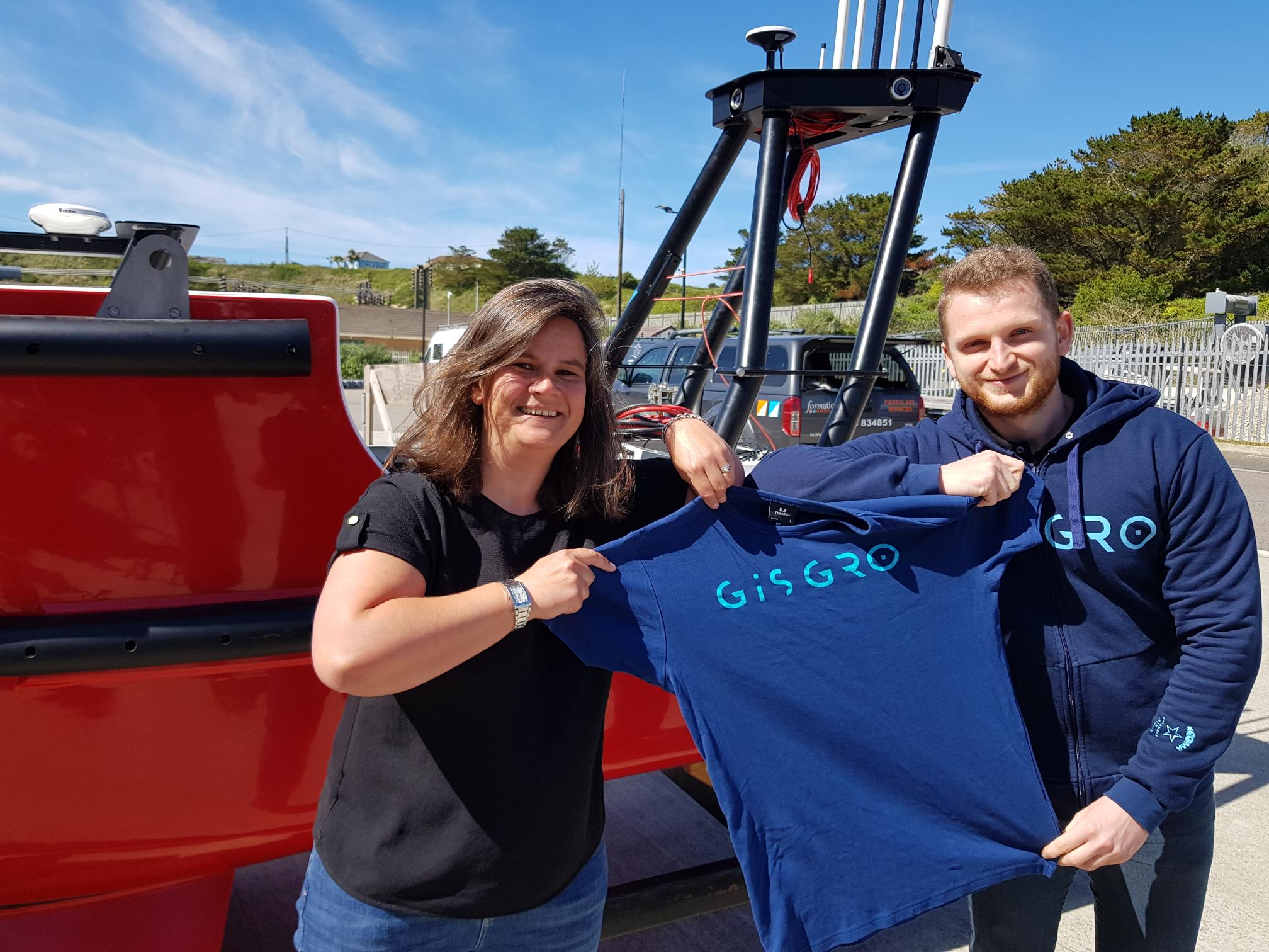
Swathe Services adds GISGRO to their survey solution portfolio
Easy delivery and utilization of survey data adds value to the workflow for surveyors.
For over 17 years, Swathe Services has excelled in supporting surveyors, contractors, ports, harbours, dredging and construction companies to achieve the best possible value from their surveys. Swathe Services provide not only high-end technology but also their expertise in consulting and training services. Whether the survey is carried out on land or under water, Swathe Services offers the best tools for the job.
A common problem for many surveyors is how to efficiently share data with their clients to help them utilise it in their everyday operations. GISGRO’s easy-to-use interface, smart tools and online environment ensure that data is available for all, in one place, at one time, enabling everyone involved to work smarter.
Swathe Services have added GISGRO online platform to their product offering, allowing surveyors to increase the value of their service and assist end customers to work smarter and utilise the data effectively.
“We are proud to add GISGRO to our excellent list of products we provide to the marine survey industry. This software will add huge value to high resolution data”, James Williams, Managing Director at Swathe Services said.
“We are excited to have Swathe Services on board with the mission of increasing the utilization of survey data in ports’ operations. Making digitalisation easier is in the interest of both of us, and the surveying expertise of Swathe Services ensures the data put in GISGRO by their clients will be first-class”, Kirsi Hänninen, CEO of VRT Finland added.
About Swathe Services
Swathe Services is a Hydrographic Survey services company based at Hayle Marine Renewables Business park, Cornwall UK.
They specialise in Hydrographic survey equipment sales and support for the global survey industry. They work with the offshore oil and gas, renewables, environmental and coastal industries.
They offer bespoke or standard packages for any survey requirement. Providing leading-edge survey technology and equipment for sale or hire along with specialist hydrographic personnel, consultancy, training and complete customer support.
About GISGRO
Everyone at GISGRO has experience in the surveying and port industries. Our passion is helping clients find optimal ways to maximize the benefits of smart technology. GISGRO is developed by VRT Finland, a 3D underwater survey pioneer established in 2010 and based in Jyväskylä, Finland.
Contacts
James Williams
Managing Director, Swathe Services
+44(0) 1872 275 642 / [email protected]
Kirsi Hänninen
CEO, VRT Finland / GISGRO
+358 44 031 0760 / [email protected]

MacArtney to launch the new NEXUS 8 multiplexer at Ocean Business 2021
Underwater technology specialists MacArtney are to launch the latest addition to the NEXUS multiplexer family at the biannual Ocean Business 2021 exhibition, held between 12-14 October in Southampton, UK.
Continuing MacArtney's long tradition of developing products in consultation with the marketplace, the NEXUS 8 is the result of considerable customer and end-user input to ensure the product will fit the need, as explained by Lars Jørgensen, Head of Product Management:
"Naturally, we have our own opinion on what a multiplexer should be able to do, but what's more important is what the customer and end-user expects and needs. We specifically wanted customer input on what they wanted from a new generation multiplexer, and their requirements for new, advanced subsea telemetry systems when developing the NEXUS 8."
Tried and trusted
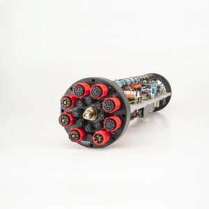
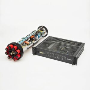
NEXUS 8 is the latest addition to the tried and trusted NEXUS multiplexer family, a range that has consistently gone from strength to strength, designed to provide an efficient link between surface and seabed. This new, future-proofed model is smaller and lighter than not only its predecessor, but also its competitors, specifically designed for environments where space is at a premium and to fit into virtually any existing subsea system.
NEXUS 8 is an HD video and multibeam sonar multiplexer, with ultra-high bandwidth and three full HD video interfaces for up to 3 HD cameras, able to provide real-time monitoring without any latency, and to run instruments and sensors for measurement, surveys, sonar, manipulation and control.
eFuses incorporated
The NEXUS 8 features intelligent programmable eFuses for dynamic performance and to save space. eFuses are ideal for subsea systems, offering flexible, dynamic programming, and avoiding time-consuming and expensive recovery operations for minor repairs.
The future, now
The new NEXUS 8 is specifically designed and developed to meet the market's demands for technology and data acquisition now and in the future. Simply the most advanced, compact and versatile product of its generation.
Launch at Ocean Business 2021
Visit the MacArtney stand B1 at Ocean Business 2021 to see the new, highly versatile, compact, future-proof NEXUS 8, and to hear more about what it can do for you.
Caption: NEXUS 8 meets tomorrow’s demands for technology and data acquisition now

_________________________________________________________________________________
For additional information, please contact Lars Jørgensen, Head of Product Management B.Sc.E.E.,
Tel. +45 7613 2000, e-mail [email protected] or visit the company website.
QPS users receive a shortcut to online data sharing and reporting in GISGRO
The year 2020 gave us a tangible example about the value of online services. Remote working became the new normal, and offices around the world discovered the need for easily accessible information. This also affects the surveying industry; how can we ensure the data we provide is usable anywhere, from workplaces to home offices?
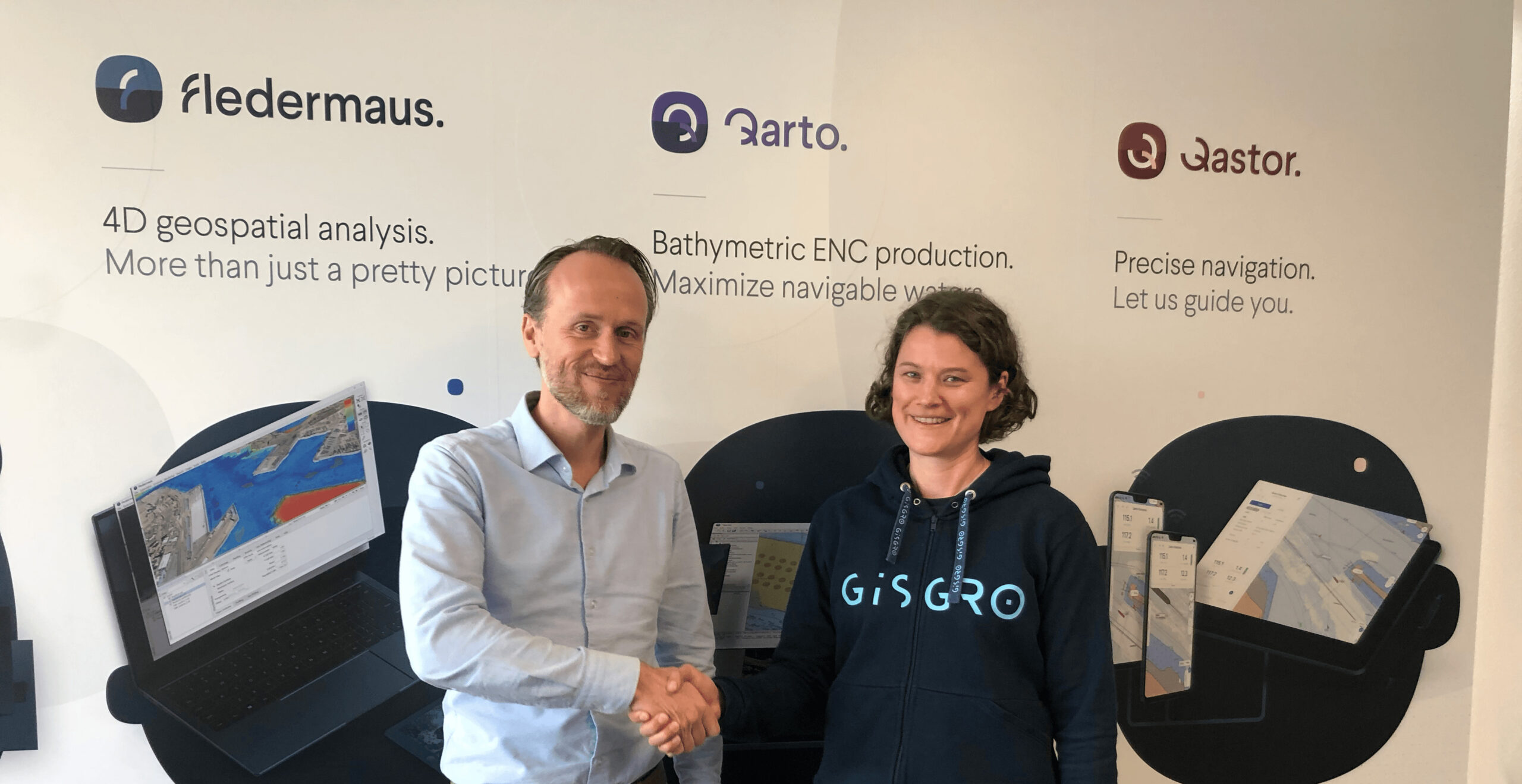
The surveyors are facing the immediate need for updating the working procedures to match the current situation. Increased competition, remote working and digitalization are the drivers for updating the workflows. GISGRO platform offers the surveyor companies an opportunity to easily share survey data online to their clients in an easy-to-understand visual format. Now it is possible for QPS users to share data through GISGRO even more easily than before.
Serving clients better with easy online delivery.
One issue in the surveying industry is the scarce utilization of the survey data by the clients. A surveyor spends a small fortune to the high-end equipment, and hours of work in polishing the data to the highest accuracy. Still, because of the lack of suitable software, the client might not even be able to see the data.
"It takes a lot of effort from a surveyor to collect data, and that is why it makes sense to make the data available in a way that stakeholders can interact with the data themselves. Our goal is that users really interact with the survey data and find insights that way."
GISGRO adds value to the whole supply chain from the surveyor to the utilizer of the data. With the integration the value is gained through a seamless workflow from the surveying and processing software all the way to the client’s laptop, where the survey data actually gets into use.
Changing the hydrographic industry
Cooperation between QPS and GISGRO changes the ways hydrographic data is utilized. The companies share innovative and forward-looking mindset. The challenge of making the most out of survey data is something the clients are just starting to realize.
"The surveyors are making the transition from delivering an end product to just making the data available. This step leads to the insight that you can do more with the data. For example, in GISGRO the survey data can immediately be used to inform other stakeholders and to take action."
QPS software users gain the advantages of online delivery simply by registering to GISGRO as a QPS user and downloading GISGRO Uploader, which enables uploading qpd-files and other supported data formats to GISGRO. If you have QPS Qinsy 9.4 version (or newer), you will have a straight access from Survey Manager to access the GISGRO Uploader for further analysis and sharing to client.
About QPS
For more than 25 years, QPS have been experts in maritime geomatics software and services. QPS is unique in that its solutions encompass the entire workflow, from the surveyor all the way to the pilot. The company’s solutions are used across a variety of industries, including hydrographic surveying, dredging, offshore construction, oil and gas, offshore wind farm support, chart production, and piloting. QPS is headquartered in Zeist, The Netherlands, and has subsidiary offices located in Portsmouth, USA; Fredericton, Canada; and Banbury, UK. QPS is a SAAB Group Company since 2012.
About GISGRO
Everyone at GISGRO has experience in the surveying and port industries. Our passion is helping clients find optimal ways to maximize the benefits of smart technology. GISGRO is developed by VRT Finland, a 3D underwater survey pioneer established in 2010 and based in Jyväskylä, Finland.
GISGRO for Surveyors
GISGRO is a cloud based system that allows surveyors to visualize, analyze and share survey data directly to clients. It’s incredibly easy for the client to use and doesn’t require any downloads, installations, high grade hardware or superfast internet. The clients can utilize the data within GISGRO for managing assets, maintenance and operations.
GISGRO for Ports
GISGRO acts a central hub for important port information, from here data can be accessed, analyzed and shared to all necessary stakeholders. Our easy to use platform ensures everyone has access to the important and accurate data needed to run a port smoothly. Through the use of smart tools, data can easily be utilized for smarter, greener and safer port operations. All in one place available anywhere and at any time.
Contact:
Kirsi Hänninen
CEO, VRT Finland / GISGRO
+358 44 031 0760 / [email protected]
Bureau Veritas delivers Approval in Principle to DriX - an innovative Unmanned Surface Vessel
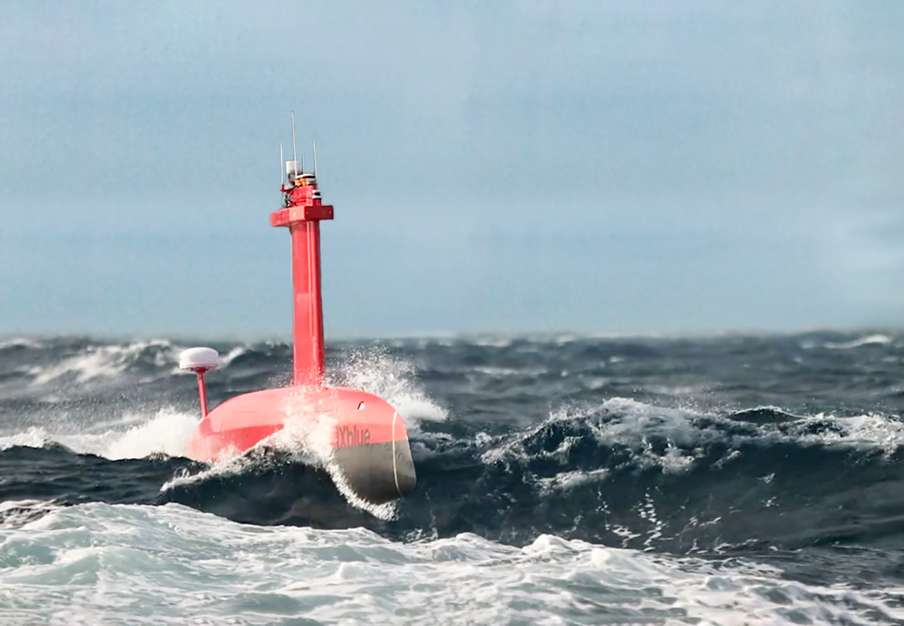
Bureau Veritas (BV), a world leader in testing, inspection, and certification, has delivered an Approval in Principle (AiP) to iXblue, a global high-tech company and a pioneer in the field of maritime autonomy, for its innovative Unmanned Surface Vessel (USV) named DriX. This AiP addresses the safety requirementsof the marine drone, which operates under the novel concept of remotely supervised autonomy.
With a length of 8 metres, DriX is an Unmanned Surface Vehicle (USV) equipped with advanced perception means, including a radar, a lidar and cameras, as well as artificial intelligence, which enable it to adapt to its environment, avoid obstacles and carry out missions autonomously. Designed to support hydrographic and geophysical surveys, water column analysis and subsea positioning operations, DriX has been used by major hydrographic institutes and energy companies worldwide.
Developed by French company iXblue, DriX has been certified by BV for its system architecture, its operational envelope, its construction (Malta Cross certificate for the hull), as well as its autonomy functions. The NI641 “Guidelines for Autonomous shipping” have provided a framework for a thorough analysis of the DriX architecture and its critical functions in a way that is adapted to autonomous marine systems.
In order to support the Approval in Principle, Bureau Veritas Solutions Marine & Offshore (BV Solutions M&O), the technical advisory component of Bureau Veritas Group, conducted a Hazard Identification (HAZID) study, as required by BV NI641. This HAZID study identified and assessed the hazards of Maritime Autonomous Surface Ships (MASS) when unmanned, taking into account the level of automation, direct and remote control, autonomy, area of operation and vessel type and design. BV Solutions M&O also conducted a Failure Mode Effects and Criticality Analysis (FMECA) on critical components previously identified during the HAZID study in order to identify, evaluate and mitigate the effects of essential equipment failure and to improve the reliability of automation systems associated with essential services.
This first certification of an Unmanned Surface Vessel (USV) by BV will help strengthen global acceptance of this technology by supporting operators in their risk analysis and mission planning for USVs deployment. This comes as the USV sector is expanding rapidly, and the acceptance of these novel marine drones depend on the capacity to demonstrate that they are safe to deploy and operate. BV and iXblue have been working in close collaboration to raise the standards and acceptance of USVs.
Stéphane Vannuffelen, Marine Autonomy Technical Director at iXblue, said: “We are convinced that the acceptance of autonomous solutions in the marine ecosystem requires a collaborative approach between manufacturers, class societies and authorities, and this work done with BV goes in that direction. This certification is a major achievement not only for DriX, but for the whole maritime industry, supporting its 4.0 transition.”
Laurent Leblanc, Senior Vice President of Technical & Operations at Bureau Veritas Marine & Offshore, commented: “Smart vessel operations can enable the maritime industry to increase productivity, predictability, and efficiency while reducing operational risk on the water. At BV, we are committed to support innovation with our robust set of standards to enable these new technologies to reach the market and ensure that they are safely implemented.”
To find out more:
- About Bureau Veritas Marine & Offshore, please visit our website.
- To watch videos about DriX, click here.
Optimize Submersible ROV Operations with Mission Planning
Deep Trekker is proud to launch our new mission planning feature! The first iteration of our mission planning update gives ROV users the ability to plot and save waypoints on their handheld controller.
If you have a REVOLUTION or PIVOT ROV with USBL you can upgrade your software to start planning your missions.
Mission planning is an incredibly important feature for ROV pilots. In addition to being a crucial step towards autonomy, mission planning makes vehicle navigation convenient and straightforward.
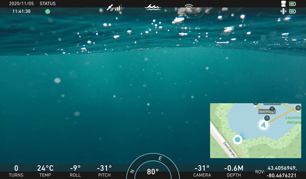
Deep Trekker’s mission planning software provides users with a useful tool to enhance their navigation and operation. In addition to plotting waypoints on the handheld controller map, users can see the path between points.
Furthermore, the use of mission planning allows pilots to visualize the size of their inspection site. With the entire mission mapped out on their screen, users can ensure thorough inspections with an accurate planning tool.
Finally, operators can clearly understand the position of their ROV within the inspection site by utilizing their on-screen waypoint map. Clear and precise graphics illustrate the ROV throughout the site, enhancing the pilot’s ability to navigate in a straightforward manner.
Consisting of latitudinal and longitudinal points, waypoints provide pilots with crucial mission planning information.
Modified with the joystick cursor control, users can conveniently interact with their waypoints in a variety of ways right from their handheld controller;
- Waypoint naming
- Waypoint editing
- Waypoint deleting
The ease in which operators can interact with their waypoints allows for quick organization and straightforward use.
In addition to the information provided on the handheld controller during use, pilots can then save their missions to view at a later date, making analysis and review convenient. In review users can conduct several useful tasks;
- View map (small view and expanded view)
- View mission path
- Open and modify existing csv files
Deep Trekker’s first mission planning release is a significant component of future fully autonomous missions.
EdgeTech Introduces New Nadir Gap-Fill Sonar for the 2205 AUV, ROV and USV Based Sonar Solutions
EdgeTech, the leader in high resolution sonar imaging systems and underwater technology, has recently introduced an innovative and new method to provide nadir gap coverage on the EdgeTech 2205 sonar platforms. Complementing this new technology is SonarWiz from Chesapeake Technology, providing a software solution to support processing and mosaicking the new gap fill solution.
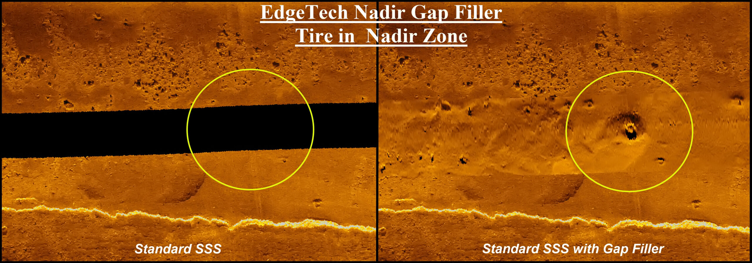
The 2205 system with gap-fill technology was designed specifically for hosted platforms operating in shallow water or within close proximity to the bottom. The sonar is ideal for Unmanned Surface Vehicles (USV) and Unmanned Underwater Vehicles (UUV/ AUV). The new 2205 system is available in a number of dual and tri-frequency configurations and the gap fill technology is available in a number of frequency options. The most popular frequency set, the 850kHz and 1600kHz dual frequency combination, is ideal for high resolution side scan sonar surveys where the nadir gap can now be filled with data while the vehicle performs single pass survey operations.
Unique to EdgeTech’s gap-fill solution is the ability to “see” the nadir gap from both the left and right sides, providing shadows from either direction, as well as in a three-dimensional aspect in the nadir gap. Gap fill shadows are perpendicular to the vehicle’s path and consistent with traditional side scan methods enabling easy interpretation of data. Additionally, gap fill data in the 2205 system is coincident with the side scan data and is therefore geospatially the same, unlike other solutions that look forward and across the vehicle path making target positions between the side scan and gap fill data less robust. The area directly below the vehicle, until now often lacking in coverage, can now be viewed with the gap data mosaicked right into the main sidescan sonar display using SonarWiz. Harold Orlinsky, General Manager of Chesapeake, said “this data combination removes the digital seam seen at the sidescan nadir. SonarWiz makes a GeoTIFF image of the seafloor with the data set.”
The EdgeTech 2205 is a compact, extremely flexible and configurable sonar system for integration on 3rd party underwater and surface vehicles. This modular unit can be configured, based on the customers’ application, to collect side scan sonar imagery, sub-bottom profiles and bathymetric data, singly or in concert with one another. The system is available either as packaged 2205 electronics enclosed in a pressure vessel, or alternatively the core electronics can be provided as boards mounted onto a chassis so the customer can integrate the system into their vehicle’s dry electronics area. Two transducer arrays, one on each side of the vehicle, provide side scan sonar, gap-fill and bathymetry. Optional sub-bottom profiler is available as well. The system can operate independent of the hosted platform by simply storing the data, or it can be configured to autonomously interoperate with the vehicle during its mission.
For more information please visit: www.edgetech.com (and www.chesapeaketech.com)