
Job Advert: SAMS hiring for Robotics and Ocean Mapping Technician
Robotics and Ocean Mapping Technician
• Location: On-site at SAMS, Oban
• Contract Type: Permanent
• Working Pattern: Full Time (37hrs per week)
• Salary: £29,619 - £33,314 per annum
• Closing Date: Monday 7th August 2023
The Ideal Candidate
SAMS are looking for an enthusiastic individual who will enjoy the varied nature of the post and the challenge of working in scientific research. You will be flexible and organised, have excellent problem-solving skills, and take a pro-active approach in your work.
The ideal candidate will be proficient in the use of bathymetric software and GIS (Geographical Information Systems) and have some hands-on experience working with hydrographic instrumentation at sea. Ideally, they would be familiar with AUVs and other autonomous platforms or be willing to learn more about these amazing technologies.
The Role
Your primary role will be as lead technician for seabed mapping surveys and data processing. You will oversee the processing and analysis of seabed mapping datasets, such as seabed bathymetry and photographic imagery from Autonomous Underwater Vehicles (AUVs) and ship-based instruments.
You will be part of a team operating a wide variety of instruments and robots during fieldwork in the UK and abroad, including multibeam systems, side-scan sonars, AUVs, Remotely Operated Vehicles (ROVs) and ocean gliders. The post also includes some out-of-hours glider piloting and offshore seagoing, which attract additional monetary compensation.
Are you interested?
Full details can be found here
Applications must include CV and Cover Letter and should be sent electronically to [email protected] quoting Job Ref ‘D31/22.LD’ in the subject heading.
Closing date for applications is Monday 7th August 2023.
Please note, candidates must have the rights to work in the UK.

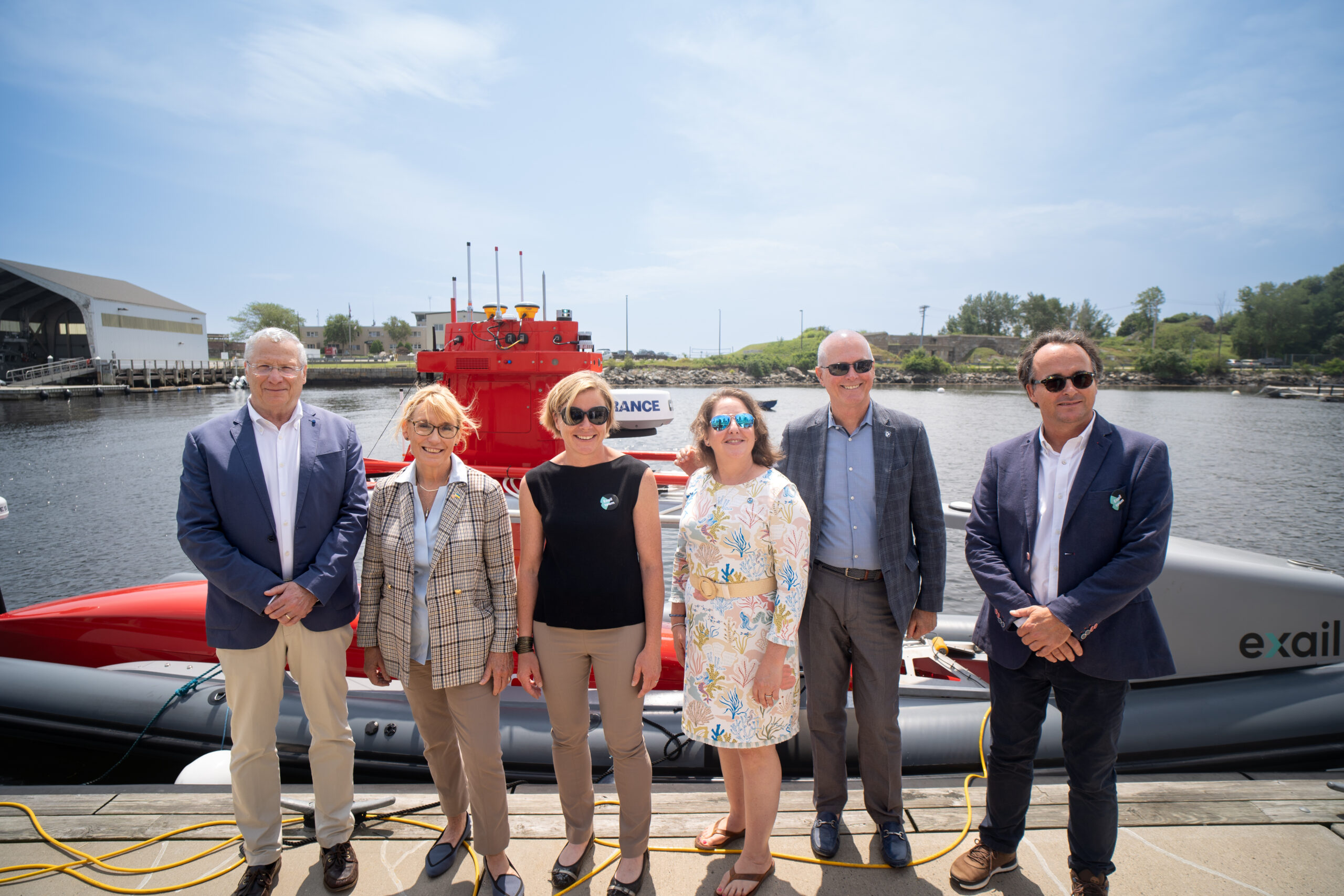
Exail and UNH open new Maritime Autonomy Innovation Hub
Exail, a global innovator in the field of maritime autonomy, has opened a new innovation hub that will engage in all aspects of marine autonomous operations to help meet the challenges of the growing blue economy.
Exail will be using the new center to deliver increased operational advantage to U.S. civil and government customers. This includes the U.S. production of its Uncrewed Surface Vessel (USV), DriX, the housing of a remote operation center to conduct worldwide remote autonomous operations, establishing local operations, maintenance and training facilities, and providing expertise on maritime autonomy while also training future generations on the use of autonomous vessels.
The new hub will be at the University of New Hampshire, a recognized leader in the field of ocean mapping research, and located within UNH’s Olson Advanced Manufacturing Center in Durham, to facilitate collaborative work with UNH’s Center for Coastal and Ocean Mapping (CCOM).
“We’ve been working together with UNH for the past six years pioneering uncrewed technologies, and we are now capitalizing on our common achievements with the opening of this new innovation hub.” States Marine Slingue, President at Exail, Inc. “We’re very proud and excited to take this next step in our U.S. adventure, and we would like to thank UNH, CCOM and NOAA, for their great support, leadership and vision on the use of uncrewed technologies that took us where we are today. We look forward to our continuous partnership with them and all the great work we achieve together to keep advancing maritime autonomy in the U.S.”.
”This exciting collaboration will not only be good for Exail and UNH students and researchers but also good for New Hampshire and the nation,” said Larry Mayer, director of the Center for Coastal and Ocean Mapping at the University of New Hampshire. ”We anticipate that it is just the start of bringing many of our other industrial partners and government colleagues to the state as we create a local engine for the new blue economy. ”
The opening of the new maritime autonomy innovation hub was celebrated on July 15th, in the presence of UNH President Jim Dean, U.S. Senator Maggie Hassan and Assistant Administrator of the National Oceanic and Atmospheric Administration (NOAA), Nicole LeBoeuf.
15th annual BlueTech Week: Maximizing impact
BlueTech Week has long been known as one of the first conferences in the world that promotes the latest and greatest innovations in sustainable ocean and water technologies. Coming from industry, policy, and academia, the speakers and participants who attend are always fascinating and inspiring. Not to mention that the commercial connections made among attendees have always made coming to this show highly worthwhile.
Based on this, TMA BlueTech are thrilled to announce that the 15th annual BlueTech Week will take place November 13th-16th in San Diego, California. This auspicious anniversary not only gives a reason to celebrate but motivates TMA to put on its best show yet. "Best" to TMA BlueTech means providing an agenda that presents a variety of angles, perspectives, and activities that lead to a multi-faceted, total quality (and highly worthwhile) event.
Click here to find out more and get in touch to be considered for a speaking slot on one of the panels.
Job Advert: UK Hydrographic Office hiring Geodesy and Tides Specialist
Location: Taunton, South West
Salary: £27,606 - £34,369 pa
Hours: Full time, part time, job share, flexible working
Contract: Permanent
The UK Hydrographic Office (UKHO) is looking for either a Senior Geodesy and Tides Specialist or someone looking to join in a development role as a Geodesy and Tides Specialist.
About the UK Hydrographic Office (UKHO)
The UKHO are a world-leading centre for hydrography, specialising in marine geospatial data to support safe, secure and thriving oceans. It fulfils the UK government’s Safety of Life at Sea obligations and are relied upon by defence users, government and global shipping.
The Geodesy & Tides section of the Terrestrial Science Data Team within the Scientific Analysis Group is a centre of excellence responsible for the provision of advice to UKHO, the wider MOD and the maritime community on matters relating to tides and geodesy.
The role
The UKHO are seeking a Senior Geodesy and Tides Specialist, with knowledge of the principles of tidal theory, tidal analysis, tidal computations or geodetic reference systems, map projections and geodetic theory OR someone with awareness and interest in these specialisms, looking to develop into the role.
The post holder is responsible for the analysis and processing of geodetic and tidal survey data into a range of databases for onward use in products and services. They will also be responsible for updating the geodetic and tides databases and data management processes to meet the requirements of the UKHO, RN and other partners.
About you
At the Senior Specialist level, you will be able to demonstrate and utilise your technical expertise within the geodesy/tides science domain, applying this to the development of processes, continual improvement of existing processes, technologies and tools, and the stewardship of geodetic/tidal data.
If undertaking the Specialist development role, you will have a good understanding of mathematics, experience working with Geospatial Information Systems such as the ESRI suite, QGIS or others and an awareness of the science Geodesy and/or Tides.
A clear development plan will be agreed with your Line Manager, which will enable you to build your skills, knowledge and experience to a level that enables you to undertake the role with confidence and credibility so you gain the skills necessary to become a Senior Specialist.
In return
The UKHO will actively empower you to develop yourself and provide flexible working practices for a healthy work/life balance. You will also benefit from a brand new award winning office, with free use of on site gym, free parking and subsidised canteen.
For a full job description, including the assessment criteria, please click the apply button to be taken to the UKHO website.
Closing date: 11:55 pm on 24th July 2023.
Apply here
Teledyne Marine launches annual photo and data contest
Teledyne Marine, a global leader in underwater technology, is thrilled to announce the launch of its highly anticipated annual photo and data contest, which invites participants worldwide to capture the breathtaking beauty of the underwater realm through their lenses. Teledyne Marine has a rich history of providing innovative solutions for offshore, academic, and defense applications. The contest is open to Teledyne Marine equipment users, allowing them to showcase their talent and passion for marine and subsea technology.
The Teledyne Marine Annual Photo and Data Contest is set to kick off on July 3rd, 2023, and will run until October 1st, 2023. This contest aims to showcase the remarkable diversity and wonder of the oceanic environment while highlighting Teledyne Marine's cutting-edge products that have revolutionized marine exploration. As part of the contest, Teledyne Marine encourages participants to submit their best images featuring Teledyne products, including, but not limited to, the SeaBat Sonar, BlueView Sonar, RDI ADCPs, Gavia AUV, and Slocum gliders. These cutting-edge technologies have been instrumental in pushing the boundaries of marine research, science, and exploration.
Participants must submit their captivating images via the official Teledyne Marine Photo and Data Contest Page.
How to Enter:
Step 1 – Visit the contest page for contest rules, upload your image, and include supporting details.
Step 2 – Share the photo / data on your social media channels and encourage friends, family, and industry associates to vote for your submission. Tag @teledynemarine on Facebook and Twitter. Teledyne Marine will share them as well. The contest is open to Teledyne Marine equipment users; each participant may submit up to three images.
"We are excited to launch the Teledyne Marine Annual Photo and Data Contest and celebrate the wonders of the underwater world," said Helle Auken Lygum, Marcom Manager, Teledyne Marine. "We believe that through the lens of talented photographers and skilled users, we can unveil the beauty and importance of our marine environment while showcasing the technological advancements we have made in underwater exploration."
Teledyne Marine is renowned for its commitment to advancing ocean science and exploration, and this photo and data contest represents an opportunity for individuals worldwide to contribute to this important endeavor. By sharing their images, participants can inspire a global audience and raise awareness about the crucial need for understanding and protecting our oceans.

Dalhousie-led research program receives $15-million to investigate how the ocean can be leveraged to mitigate climate change
Dalhousie University has received nearly CAD$15-million from the Carbon to Sea Initiative to lead the Ocean Alk-align research program, a global five-year project that will bring researchers together from around the world to study ocean alkalinity enhancement – an approach for atmospheric carbon removal that aims to mitigate climate change.
The process of alkalinity enhancement is compared to adding an antacid to the ocean, the kind we take for heartburn or when our stomachs are upset. Over the past 200 years, the burning of fossil fuels has increased ocean acidification and reduced its ability to absorb carbon dioxide (CO2) from the atmosphere. Through targeted enhancement of ocean alkalinity, Dalhousie oceanographer Dr. Katja Fennel and her colleagues will study if they can reverse ocean acidification to make the ocean more receptive to CO2 absorption.
The Dalhousie-led Ocean Alk-align project is supported by the Carbon to Sea Initiative, a non-profit program funded by philanthropic foundations in the United States, Canada, and Europe. Carbon to Sea seeks to assess the conditions under which ocean alkalinity enhancement can become a safe, cost-effective, and scalable method for atmospheric CO2 removal. The $15-million CAD grant to Alk-align is the largest funding commitment of the initiative to date.
"Currently, ocean alkalinity enhancement is not a mature technology and its environmental impacts have not been assessed in the field,” said Dr. Fennel, who is the lead principal investigator of the Ocean Alk-align research program. “Our research consortium will tackle the three most pressing research issues: the efficiency and permanence of CO2 removal, its environmental risks and potential benefits, and the monitoring and verification of CO2 uptake.”
Dr. Fennel notes it is now widely accepted that global efforts to reduce CO2 emissions are not enough to veer us off a course toward catastrophic climate change. The United Nations’ Intergovernmental Panel on Climate Change says to meet these targets, the world needs to remove 10 giga tonnes (equivalent to one billion tonnes) of CO2 from the atmosphere per year by the middle of the century, and 20 giga tonnes per year by the end of the century. Ocean carbon alkalinity could be a key to meeting these targets.
“If we’re going to avoid the worst impacts of climate change, we need to aggressively reduce emissions and remove carbon from the atmosphere,” said Mike Schroepfer, board chair of Carbon to Sea and co-founder of Additional Ventures, a purpose-driven organization that started and spun-out Carbon to Sea.
“Scientists agree that ocean alkalinity enhancement has enormous potential to permanently remove and store carbon and more funding for research is needed. We are here to respond to the call for research funding and answer basic scientific questions about the safety and efficacy of various approaches to ocean alkalinity enhancement. If we find that ocean alkalinity enhancement can be applied at scale, we can unlock one of the most efficient, cost-effective approaches to carbon dioxide removal for humanity. I’m grateful to the whole network of funders, researchers, partners, and the amazing team at Carbon to Sea for their bold commitment to pursue this work."
As chief principal investigator, Dr. Fennel will facilitate collaborations between Dalhousie and a global team from some of the world’s foremost centres of ocean research, including GEOMAR Helmholtz Center for Ocean Research Kiel and Hamburg University in Germany, and University of Tasmania and Southern Cross University in Australia.
“As a global leader in ocean science, Dalhousie is perfectly positioned to take the lead in this emerging area in the fight against climate change,” said Dr. Alice Aiken, Dalhousie’s vice president research and innovation. “Under Dr. Katja Fennel’s direction, this research program will play a key role in advancing the science of ocean-based carbon removal. It’s a significant opportunity and it’s our responsibility to the world.”
At the end of April, Dalhousie was also announced the recipient of a $154 million grant from the Government of Canada to help fund the Transforming Climate Action research program to study the ocean’s central role in climate change. One of the three major themes of the program is focused on mitigation strategies and ocean-based CO2 removal in particular. Collaboration between the Ocean Alk-align and Transforming Climate Action research programs has the potential to enhance and substantiate global networks and data sharing with possibilities to significantly magnify impact.
“The math is relatively simple – we need to pair emissions reduction with environmentally responsible carbon dioxide removal solutions. My interest in ocean alkalinity enhancement is rooted in a deep love of the ocean, a recognition that climate change is a catastrophe for marine ecosystems, and the belief that our ocean can be a part of the solution,” said Dr. Antonius Gagern, executive director of Carbon to Sea. “The growing scientific community working on ocean alkalinity enhancement includes the best minds across a range of disciplines, from biogeochemistry to ocean engineering, and is focused on systematically testing this hypothesis.”
Dr. Fennel says it’s essential that researchers outside of the private sector play a central role in determining the future of ocean alkalinity enhancement, noting that an objective approach is required to ensure it is done correctly, if at all.
“It is of utmost importance that these issues are investigated by scientists who have no financial interests in the research outcomes and are driven solely by the desire to ensure safe implementation if, and only if, ocean alkalinity proves to be effective at removing CO2,” said Dr. Fennel. “This must happen before it is implemented and scaled up.”
Read the Carbon to Sea Initiative’s media release about its larger investment in Ocean Alkalinity Enhancement research.

Greensea demonstrates successful UXO survey to locate buried munitions
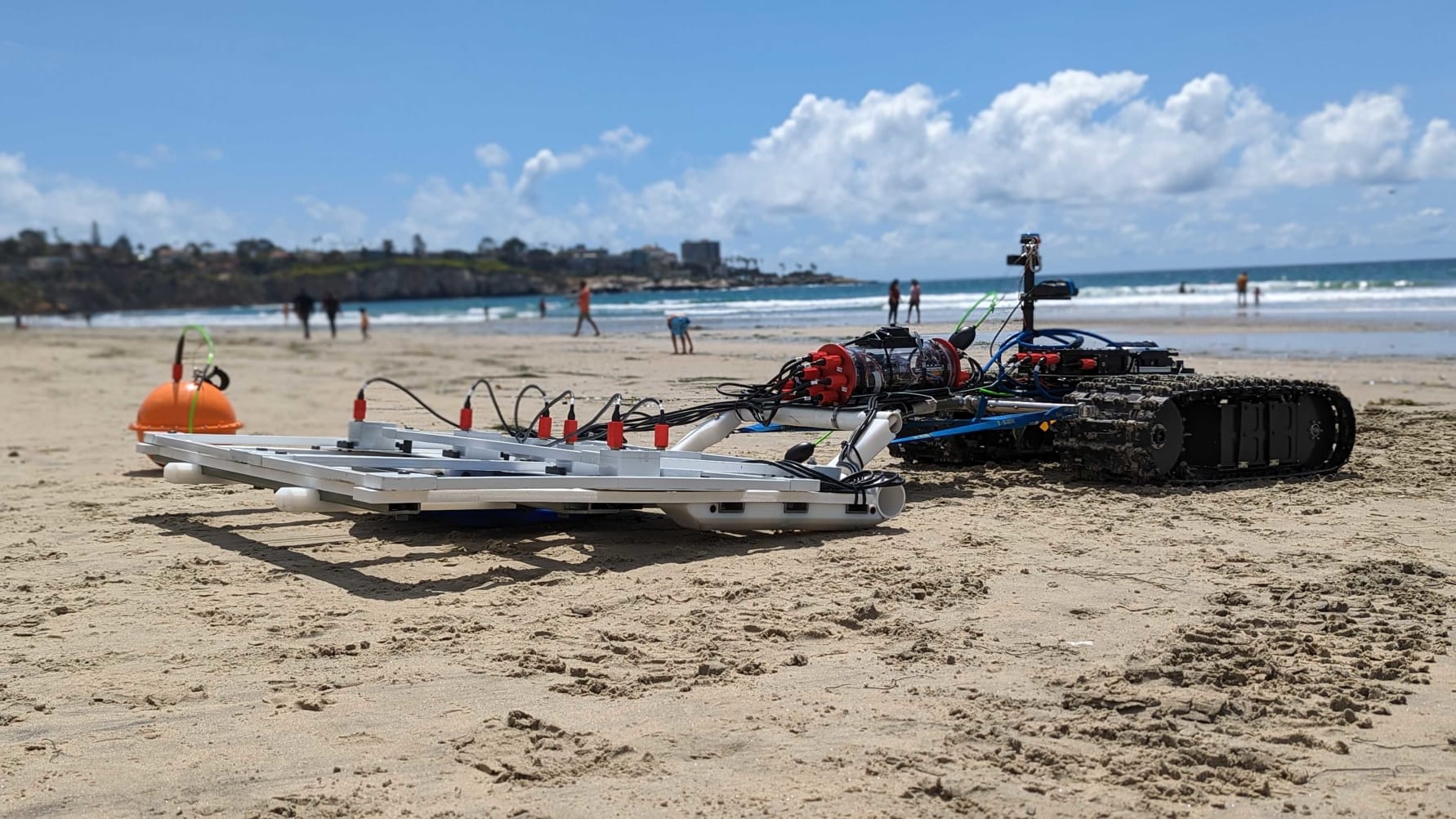
Greensea Systems, Inc. (Greensea), a leading provider of advanced robotics solutions, is pleased to announce the successful demonstration of a mission to locate buried munitions in the surf zone.
This UXO survey demonstrated the power and flexibility of OPENSEA to rapidly integrate and deploy a new sensor suite for the task while showcasing the capabilities of the Bayonet 250 AUGV, which was selected as a finalist in The Defense Innovation Unit's (DIU) Autonomous Amphibious Response Vehicle (A2RV) program's rapid prototyping phase. Out of 67 proposals, the Bayonet 250 crawler prototype, developed in partnership with Greensea, was chosen for its exceptional performance and potential to detect, identify, and neutralise naval mines and other explosive hazards in the challenging surf and beach landing zones.
Operating over 8 days and covering 18 square kilometers in depths of up to 10 feet, amidst wave heights of 4-6 feet in the challenging surf zone, the Bayonet 250 provided a stable and reliable platform for conducting the survey that included a towed sled equipped with White River Technology's (WRT) marine APEX technology, seamlessly integrated into Greensea’s software platform, OPENSEA.
The rapid integration of the sensor sled facilitated the detection and classification of objects, with a buried depth of up to 3 meters based on material composition.
"We are very excited about the recent success of crawler-based 3DEM sensing for advanced geophysical classification of munitions in the most challenging environments like surf zones”, says Greg Schultz, Chief Technology Officer for WRT. “The combination of autonomous amphibious crawlers, like the Bayonet units, and the WRT APEX dynamic electromagnetic classification arrays, appear ready to go where divers and towed systems have not been able to in the past".
David Pearson, Program Manager at Greensea, expressed his satisfaction with the successful mission demonstration, stating: "The success of this program and our ability to operate effectively in the challenging surf zone environment is a testament to the strength of our team and our commitment to innovation. By quickly integrating a new sensor for buried UXO and munitions, mobilising an operations team, and collecting data in demanding conditions, we have demonstrated our capability to locate and address explosive hazards in one of the most dynamic and challenging operational environments. This achievement showcases Bayonet, Greensea, and our partner's expertise to make the impossible possible. Positioning us as the trusted partner in providing solutions for maritime and underwater operations from the beach to the deep."
Throughout the mission, the Bayonet 250 successfully identified buried targets based on burial depth and signal signature, highlighting its ability to detect and identify explosive hazards in both the surf and on beach landing zones. The collaboration between Greensea, Bayonet, and White River Technology, resulted in an exceptional demonstration that further solidified their position as industry leaders in marine and underwater operations.
The Society of Maritime Industries joins Seabed 2030
A new partnership has been announced between The Nippon Foundation-GEBCO Seabed 2030 Project and the Society of Maritime Industries (SMI), a leading trade association representing the UK's maritime engineering and business sectors.
The parties will work together to advance the field of ocean science, in pursuit of the complete map of the world’s ocean floor.
Seabed 2030 is a collaborative project between The Nippon Foundation and the General Bathymetric Chart of the Oceans (GEBCO), which seeks to inspire the complete mapping of the world’s ocean by 2030, and to compile all the data into the freely available GEBCO Ocean Map. The Project is formally endorsed as a Decade Action of the UN Ocean Decade. GEBCO is a joint programme of the International Hydrographic Organization (IHO) and the Intergovernmental Oceanographic Commission (IOC), and is the only organisation with a mandate to map the entire ocean floor.
Representing over 170 member organisations involved in various sectors of the maritime industry, SMI has been instrumental in driving developments and innovation within the maritime sector - it is also a trusted advisor to the UK government and actively seeks out ways in which the industry can progress as a whole.
SMI’s approach is entirely member-focused, with members’ interests represented by six councils centering on marine science and technology; commercial marine; maritime autonomous systems; digital technology; ports infrastructure; and maritime defence and security.
“We are delighted to welcome the Society of Maritime Industries to our network of partners,” commented Seabed 2030 Project Director Jamie McMichael-Phillips. “SMI is able to contribute a wealth of industry knowledge and resources which will help us edge closer to our goal of 100 per cent of the ocean floor mapped by the end of the decade.”
Chief Executive of SMI Tom Chant MBE said: “By collaborating with Seabed 2030, we aim to help facilitate knowledge sharing, foster innovation and drive sustainable growth within the maritime industry.
“The comprehensive mapping of the ocean floor is essential to unlocking new opportunities across various sectors and, crucially, for environmental conservation.”
All data collected and shared with the Seabed 2030 project is included in the free and publicly available GEBCO global grid.
Register now for the 66th Marine Measurement Forum in Plymouth, Devon
The Plymouth Marine Laboratory are delighted to announce that the 66th Marine Measurement Forum will be hosted in the port city of Plymouth, Devon, on June 27th 2023.
Hosted by the National Centre for Coastal Autonomy (NCCA) (founded by the partners in Marine Research Plymouth – the Marine Biological Association, Plymouth Marine Laboratory (PML) and the University of Plymouth), the Forum will be held at PML’s main site on Plymouth Hoe which overlooks the historic waterfront and Plymouth Sound.
A full day of talks, presentations and networking opportunities will be followed by an evening reception on June 27th.
Registration will be open to all - Registration Fee: £40+ VAT
Job Advert: EGS international hiring for Business Development & Tendering Support
EGS international are growing its commercial team to meet increasing demand for its services, with particular focus on offshore renewables. This is an exciting opportunity to contribute to its success in providing survey services to offshore industries.
Your core role will encompass three disciplines; Business Development, Tendering Support and Marketing Support.
Business Development – research opportunities, contact potential clients and increase awareness of EGS as a service provider. Assess new geographical opportunities within reach of our offshore vessel. Help build customer relationships.
Tender Support – follow up and respond to expressions of interest and pre-qualification requirements, contribute to tender assessment & submissions.
Marketing – assist with marketing campaigns and attend exhibitions. Contribute to marketing material and log client feedback.
A knowledge of the survey industry would be desirable and commercial experience would be beneficial, however full training will be provided.
Why should you apply?
• Competitive salary package.
• Company pension scheme.
• Ongoing training and development opportunities.
• Flexible and/or hybrid working conditions considered.
Main Responsibilities:
• Be aware of all operational and planned OWF sites and identify procurement contacts for each. Promote EGS and regularly update clients on EGS availability and capability.
• Look at wider geographical regions for expansion, particularly to extend the survey season and increase vessel utilisation in the quieter winter period.
• Take the lead with RFI/PQQ responses, identify departmental and external support that’s required to complete the requests and follow up after submission.
• Review tender documents, identify submission requirements, and liaise with technical advisors & sub-contractors to prepare good quality proposals and quotations within client deadlines.
• Secure feedback from successful and unsuccessful tenders, for analysis, business planning and continual improvement.
• Keep Commercial Dept. KPI’s updated on a regular basis. Review and relay client comments to senior management.
• Update client portals and online tender websites with current information, make sure notifications/alerts are functional.
• Man the EGS stand at trade exhibitions and join its team when visiting trade shows to help promote EGS. Identify exhibitions and events to attend.
• Review trade magazines, websites etc. to assess and follow up potential opportunities.
• Identify market trends, provide feedback on new technologies, resources and survey methodologies that can make EGS more competitive.
To express an interest please email your Cover Letter and CV to [email protected]